Magog River facts for kids
Quick facts for kids Magog River |
|
|---|---|

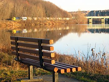
View of Magog River at the edge of Sherbrooke.
|
|

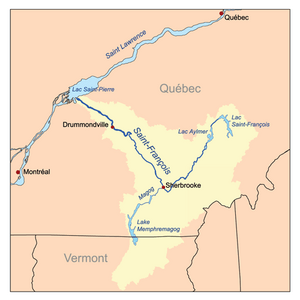
Map of the Saint-François River watershed
|
|
| Native name | Rivière Magog |
| Other name(s) | Sekosonotek |
| Country | Canada |
| Province | Quebec |
| Region | Estrie |
| Cities | Magog, Quebec, Sherbrooke |
| Physical characteristics | |
| Main source | Lake Memphremagog Magog, Estrie, Quebec, Canada 208 m (682 ft) 45°15′43″N 72°9′32″W / 45.26194°N 72.15889°W |
| River mouth | Saint-François River Sherbrooke, Estrie, Quebec, Canada 152 m (499 ft) 45°24′20″N 71°53′25″W / 45.40556°N 71.89028°W |
| Length | 31.8 km (19.8 mi) |
| Depth |
|
| Basin features | |
| Progression | Saint-François River→ Saint Lawrence River→ Gulf of Saint Lawrence |
| River system | Saint Lawrence River drainage basin |
| Basin size | 1,900 km2 (730 sq mi) |
| Tributaries |
|
The Magog River is a small but important river in Quebec, Canada. Its name in the Abenaki language is Sekosonotek. This means "the river which makes detours."
The river starts at Lake Memphremagog and flows through the cities of Magog and Sherbrooke. It travels from the southwest to the northeast. Finally, it joins the Saint-François River right in the middle of Sherbrooke.
Both Magog and Sherbrooke cities are built along the Magog River. Engineers from the Université de Sherbrooke even built a special plastic bridge over it!
Contents
The Magog River's Journey
The Magog River begins its journey in the city of Magog. It starts at an elevation of 208 metres (682 ft) above sea level. This is the only place where water flows out of Lake Memphremagog.
The Magog River gets its water from many smaller streams that feed into Lake Memphremagog. Some of these streams even come from the United States. All the land that drains into the Magog River covers about 1,900 square kilometres (730 sq mi).
Dams and Lakes Along the Way
Near the start of the river, about 1.5 kilometers in, you'll find the first dam. It's called the Memphrémagog Dam. A bit further, at 4.1 km, the Red stream joins the river.
Then, at 5.6 km, there's another dam called La Grande-Dame. After this, the river flows into Lake Magog at 9.8 km. This lake is about 6.5 kilometres (4.0 mi) long.
While in Lake Magog, the river collects water from Black Brook and Red Brook. The Magog River then continues its path from the northeastern end of the lake at 16.3 km.
Streams and Falls in Sherbrooke
As the river keeps going, it picks up water from Grass Island stream (18.5 km) and Gordon stream (19.4 km). Then, it reaches the Rock Forest dam at 19.6 km.
Later, the Magog River gets more water from Nick stream (21.5 km) and Dodds stream (23 km). It then flows to the Drummond dam at 25 km. After this, the river widens to form Lac des Nations at 29.1 km, right in the heart of Sherbrooke.
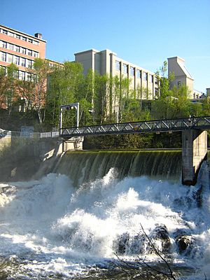
The river then drops into a deep gorge past the Paton dam (30.4 km). It falls 38 metres (125 ft) over about 1.3 kilometres (0.81 mi). Along this stretch, it passes two more dams: Frontenac (30.9 km) and Abénaquis (31.4 km).
Finally, the Magog River finishes its journey by emptying into the Saint-François River. This happens at an elevation of 141 metres (463 ft). The total length of the river, including Lake Magog, is 31.8 kilometres (19.8 mi). It drops 67 metres (220 ft) from start to finish.
History of the Magog River
The Magog River has a big drop in elevation from its source to where it ends. This drop was very important for early industries. In the past, the river had a fast current. It flowed through a natural channel that was between 92 and 150 meters (490 ft) wide.
The river also had "great falls" before joining the Saint-François River. Because of this significant drop, seven dams were built along the river. Three of these dams are in the last 1,200 metres (3,900 ft) of the river, in a gorge in Sherbrooke.
One of these dams, built by the Paton Co., created Lac des Nations. This lake was like a storage tank for water. It helped make sure that factories always had enough water power, even when the river's water level was low.
In the 1800s and 1900s, the Magog River was a busy place for factories. They used the river's power for their machines. Today, most of these factories are gone. The riverbanks are now mostly home to houses, parks, and wooded areas.
Dams on the Magog River
Many dams have been built on the Magog River over the years. Some are still in use today, generating electricity. Here is a list of some of the important dams:
| Name | Location | Years in operation |
|---|---|---|
| Austin-Taylor Dam | Magog | 1796-1822 |
| Hyatt-Ball Dam | Sherbrooke | 1802-1842 |
| Weatherbee Dam | Magog | 1822-1883 (reconstructed in 1853) |
| Goodhue Dam | Sherbrooke | 1828-1854 |
| 5th BALC Dam | Sherbrooke | 1842-1910 |
| 4th BALC Dam | Sherbrooke | 1849-1919 |
| 1st BALC Dam | Sherbrooke | 1854-1926 |
| 3rd BALC Dam | Sherbrooke | 1871-1902 |
| 2nd BALC Dam | Sherbrooke | 1877-1916 |
| MT&P Dam | Magog | 1883-1915 |
| BALC Dam | Sherbrooke (Deauville) | 1883-1911 |
| Hydro-Magog Dam/hydroelectric center | Magog | 1897-1911 |
| Frontenac I Dam/hydroelectric center | Sherbrooke | 1902-1916 |
| Drummond Dam/hydroelectric center | Sherbrooke | 1908–present |
| Abénaquis Dam/hydroelectric center (previously known as SR&P) | Sherbrooke | 1910–present |
| La Grande-Dame Dam/hydroelectric center (also known as Hydro-Magog II) | Magog | 1911–present |
| Rock Forest Dam/hydroelectric center | Sherbrooke (Rock Forest) | 1911–present |
| Frontenac II Dam/hydroelectric center | Sherbrooke | 1916–present |
| Memphrémagog Dam/hydroelectric center (also known as Dominion Textile) | Magog | 1920–present |
| Paton Dam/hydroelectric center | Sherbrooke | 1927–present |
River's Name
The Abenaki people called this river "Pskasewantekw" or "Pskusewantegw." This name means "the river which makes detours," which describes its winding path.
The official name "rivière Magog" was recognized on December 5, 1968. This was done by the Commission de toponymie du Québec, which is a group that names places in Quebec.
 | James Van Der Zee |
 | Alma Thomas |
 | Ellis Wilson |
 | Margaret Taylor-Burroughs |


