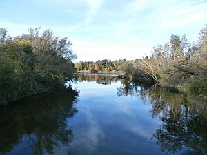
Massawippi River facts for kids
Quick facts for kids Massawippi River |
|
|---|---|
| Native name | Rivière Massawippi |
| Country | Canada |
| Province | Quebec |
| Region | Estrie |
| Physical characteristics | |
| Main source | Lake Massawippi 180 metres (590 ft) |
| River mouth | Saint-François River 170 metres (560 ft) |
| Length | 20 kilometres (12 mi) |
| Basin features | |
| River system | Saint Lawrence River |
The Massawippi River is a river in Quebec, Canada. It flows through areas like North Hatley and the city of Sherbrooke. This river is a tributary (a smaller river that flows into a larger one) of the Saint-François River. The Saint-François River then flows into the mighty Saint Lawrence River.
Where Does the River's Name Come From?
The small village of Massawippi was founded in 1800. It was started by people called Loyalists. These were people who stayed loyal to Britain during the American Revolution.
The name Massawippi might come from an Algonquin word, nasawipi. This word means "between the waters." Nasaw means "between" or "middle," and nipi means "water."
Another idea is that the name comes from the Abenaki language. In Abenaki, it could mean "much clear water." Many places in this area have names from the Abenaki language. Some examples are Magog, Lake Memphremagog, Coaticook, and Mégantic.
The River's Journey
The Massawippi River starts in Lake Massawippi near North Hatley. From the North Hatley Bridge, where it leaves the lake, the river flows for about 19.0 kilometres (11.8 mi) (about 12 miles). It drops about 10 metres (33 ft) (33 feet) in height along its path.
Here's how the river flows:
- It goes about 1.2 kilometres (0.75 mi) (0.75 miles) northeast. This part leads to the North Hatley dam.
- Next, it flows for about 9.2 kilometres (5.7 mi) (5.7 miles) towards the northeast. It makes a curve to the east, then a hook to the northwest. Along this part, it collects water from the Eustis stream. It also meets the Coaticook River.
- Then, it travels about 6.6 kilometres (4.1 mi) (4.1 miles) north. Here, it collects water from Jack's Creek and the Eaton River.
- Finally, it flows about 2.0 kilometres (1.2 mi) (1.2 miles) north. It goes under Route 108 and a railway bridge. The river then reaches its end in the Lennoxville area of Sherbrooke. This is where it flows into the Saint-François River.
The spot where the Massawippi River joins the Saint-François River was once called "petite fourche." This means "little fork" in French. The Abenaki people, French missionaries, and early settlers used this name. Later, this area became known as Lennoxville.
Fun Things to Do Along the River
An old railway track runs right along the Massawippi River. This track has been turned into a fun bike path! The bike path is part of a bigger network called the Route Verte. This means you can enjoy cycling next to the beautiful river.
 | James B. Knighten |
 | Azellia White |
 | Willa Brown |


