
Coaticook River facts for kids
Quick facts for kids Coaticook River |
|
|---|---|
 |
|
| Country | United States, Canada |
| Physical characteristics | |
| Main source | Norton Pond, Essex County, Vermont |
| River mouth | Massawippi River, Waterville, Quebec 149 m (489 ft) |
| Length | 56 km (35 mi) |
| Basin features | |
| Basin size | 364 km2 (141 sq mi) |
| Tributaries |
|
The Coaticook River is a cool river that starts in Vermont, United States, and flows mostly north into Quebec, Canada. It's a big part of the Estrie region in Quebec. The river ends by joining the Massawippi River near Waterville, close to the city of Sherbrooke. From there, its waters travel through the Massawippi and Saint-François River to reach the mighty St. Lawrence River.
Contents
What Does "Coaticook" Mean?
The name "Coaticook River" comes from the Abenaki language. The Abenaki are a group of Indigenous people from this area. Their word koatikeku means "River of the land of the white pine".
Why White Pines?
White pines were very common trees in this region. You could find them all around the river and in the nearby upper Connecticut River valley. Even names like Coös, which you might see in Coös County, New Hampshire, come from this type of tree.
The name "Coaticook River" became official on December 5, 1968. This was decided by the Commission de toponymie du Québec, which is like a special group that names places in Quebec.
Where Does the Coaticook River Flow?
The Coaticook River starts its journey in a place called Norton Pond. This pond is about 4.1 kilometers (2.5 mi) long and sits high up at 407 meters (1,335 ft) above sea level. It's located in Essex County, Vermont, south of the border between Canada and the United States.
Starting in the USA
The river flows northward for about 6.8 kilometers (4.2 mi) while still in the United States. It passes through a beautiful valley filled with forests and farms. You can often see a railway and Vermont Route 114 running alongside the river on its east side.
Crossing into Canada
After crossing the international border, the Coaticook River enters Quebec. It then flows through several towns and villages:
- The small community of Stanhope, which is part of the larger Coaticook area.
- The village of Dixville.
- The city of Coaticook itself. Here, the river has carved a deep passage, about {{convert|50|m|ft|adj=mid|-deep]], through ancient rocks. This took thousands of years!
- The west side of the village of Compton.
- The village of Waterville.
Joining Other Rivers
North of Waterville, the Coaticook River meets the Massawippi River. This meeting point is about 5.9 kilometres (3.7 mi) upstream from where the Massawippi River joins the Rivière aux Saumons. It's also about 8.8 kilometres (5.5 mi) upstream from where the Massawippi River flows into the Saint-François River near Lennoxville, which is southeast of the center of Sherbrooke.
Images for kids
-
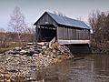
Pont Drouin is one of the bridges crossing the Coaticook River.
-
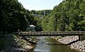
Many bridges cross the Coaticook River along its path.


