Sutton River (Missisquoi River tributary) facts for kids
Quick facts for kids Sutton River |
|
|---|---|

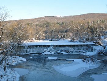
Waterfall in Abercorn, Quebec
|
|
| Native name | Rivière Sutton |
| Other name(s) | North Branch Missisquoi River for a 2,7 km in Vermont |
| Country | Canada |
| Province | Quebec |
| Region | Montérégie |
| Regional County Municipality | Brome-Missisquoi Regional County Municipality |
| Municipality | Sutton, Abercorn |
| Physical characteristics | |
| Main source | Lake Spruce Sutton 746 m (2,448 ft) 45°05′20″N 72°32′55″W / 45.08889°N 72.54861°W |
| River mouth | Missisquoi River Richford, in Franklin County 128 m (420 ft) 44°59′30″N 72°41′01″W / 44.99167°N 72.68361°W |
| Length | 23.9 km (14.9 mi) |
| Basin features | |
| Progression | Missisquoi River, Lake Champlain, Richelieu River, Saint Lawrence River |
| Tributaries |
|
The Sutton River (called Rivière Sutton in French) is a river that flows across the border between Canada and the United States. It starts in Quebec, Canada, and flows south into Vermont, USA.
In Canada, the river passes through the towns of Sutton and Abercorn in the Montérégie region of Quebec. Once it crosses into Vermont, it is known as the North Branch Missisquoi River for about 2.7 kilometers (1.7 miles). It then joins the Missisquoi River.
The area around the Sutton River is known for its tourism and culture. Many people visit for outdoor activities like skiing and hiking. In 2014, Sutton had 52 tourist businesses, creating 575 jobs. About 46,000 visitors come to the area each year. Besides tourism, farming and forestry are also important activities in this valley.
The river usually freezes over from mid-December to the end of March. It's generally safe to walk on the ice from late December to early March. The amount of water in the river changes with the seasons and how much rain falls.
Contents
Where Does the Sutton River Start and End?
The Sutton River begins at Spruce Lake, which is high up on the western side of Mont Sutton in Quebec. This lake is like a small bowl nestled between two mountains, Mont Gagnon and Le Round Top.
From Spruce Lake, the river flows mostly south for about 23.9 kilometers (14.9 miles). As it flows, it drops a lot in elevation, about 618 meters (2,028 feet).
The River's Journey in Canada
As the Sutton River leaves Spruce Lake, it flows through Lake Vogel. It then winds its way through the village of Sutton, even crossing the Canadian Pacific Railway tracks. Along its path, it collects water from several smaller streams. It also crosses important roads like Jordan Road and Quebec Route 139. The river continues its journey south, passing through different areas and picking up more water from other streams before it reaches the Canada-US border.
The River's Journey in the United States
After crossing the border into the United States, the river changes its official name to the "North Branch Missisquoi River." For about 2.7 kilometers (1.7 miles), it flows southwest through farmland. It eventually joins the Missisquoi River in Richford, Vermont. This meeting point is about 0.7 kilometers (0.4 miles) west of downtown Richford.
Flooding and the River
Like many rivers, the Sutton River can sometimes flood. The town of Sutton has rules about building near the river in areas that might flood.
A big flood happened on July 14-15, 1997. Heavy rains caused the river to overflow. A bridge on Claybank Road in Abercorn was badly damaged. The floodwaters washed away parts of the road, and the wooden bridge structure broke apart. Debris from the flood blocked the stream. Many roads in Abercorn, especially Spencer and Church streets, were damaged during this event.
Why Are There Two Sutton Rivers?
The name of the Sutton River can sometimes be confusing because there are other rivers with similar names.
- The part of the Sutton River in the US is called "North Branch Missisquoi River." This can be mixed up with the Missisquoi River North, which is a different river entirely. The Missisquoi River North flows only in Quebec and joins the main Missisquoi River about 31.9 kilometers (19.8 miles) upstream.
- Also, in Vermont, there is another river called the Sutton River. This second Sutton River is a tributary of the West Branch Passumpsic River, which is part of the larger Connecticut River system.
The name "Rivière Sutton" was officially recognized in Quebec on December 5, 1968, by the Commission de toponymie du Québec (Quebec Place Names Board).
 | Audre Lorde |
 | John Berry Meachum |
 | Ferdinand Lee Barnett |

