
Geography of the United States facts for kids
The United States is one of the largest countries in the world. Only Russia and Canada are bigger. If you don't count the Great Lakes area, China is also larger. The United States covers about 9.6 million square kilometers (3.7 million square miles).
Its geography changes a lot across the country. You can find many different landscapes here. The highest point is Mount McKinley in Alaska. The lowest point is Death Valley in California.
In the eastern part of the country, you'll see meadows and forests. The Appalachian Mountains also run through the east. In the middle of the country, there are the Great Plains. This is a large, flat area. The mighty Mississippi and Missouri rivers flow through the middle of the US.
West of the plains, you'll find the tall Rocky Mountains. Further west, there are deserts and beautiful coastal areas. The Pacific Northwest has thick forests. Alaska has very cold, Arctic regions. Hawaii is made up of volcanic islands. The US also has a very long coastline with many beaches.
The exact middle point of the entire US is in Butte County, South Dakota. For just the 48 connected states, the center is in Smith County, Kansas.
US Weather and Climate
The weather in the United States changes a lot, just like its geography. In Florida and Hawaii, the climate is tropical. This means it's hot and wet in summer, and warm and dry in winter. In Alaska, it's very cold all year, like the tundra.
Many parts of the country have warm summers and cold winters. Most of the northern US gets snow in winter. Some areas in the western US, like parts of California, have a Mediterranean climate. This means they have warm, dry summers and mild, wet winters.
The southeastern United States can experience strong storms called hurricanes. Some southern parts of the US are subtropical. This means they have hot summers and cool winters. Tornadoes happen very often in the Midwest region.
The hottest temperature ever recorded was 57 degrees Celsius (134 degrees Fahrenheit). The coldest temperature ever recorded was -62 degrees Celsius (-80 degrees Fahrenheit).
Images for kids
-
A map of the United States
-
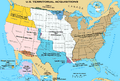
How the United States grew over time
-
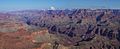
The amazing Grand Canyon
-
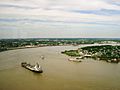
The wide Mississippi River
-
The Everglades and Florida Keys
-
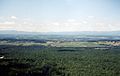
The Shenandoah Valley in Virginia
-
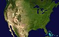
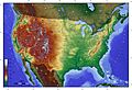
A satellite view of the contiguous United States. You can see forests, grasslands, and mountains.
-
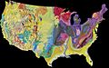
A map showing the different land types and ages in the US.
-
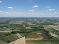
Flat, farmable land in northern Ohio.
-
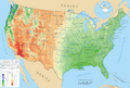
A map showing how much rain and snow falls across the US.
-
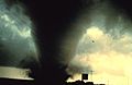
A powerful tornado near Dimmitt, Texas in 1995.
-
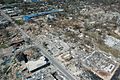
Damage in Gulfport, Mississippi from Hurricane Katrina in 2005.
-
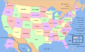
A political map of the United States with all 50 states and territories.
-
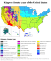
Map showing different climate types in the US.
-
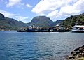
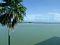
Pago Pago Harbor in American Samoa, known for its high rainfall.


See also
 In Spanish: Geografía de Estados Unidos para niños
