Dimmitt, Texas facts for kids
Quick facts for kids
Dimmitt, Texas
|
|
|---|---|
|
City
|
|

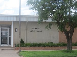
Dimmitt City Hall (2010)
|
|

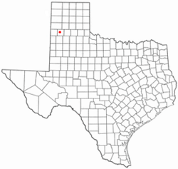
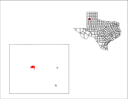
Location within Castro County and Texas
|
|
 |
|
| Country | United States |
| State | Texas |
| County | Castro |
| Area | |
| • Total | 3.26 sq mi (8.43 km2) |
| • Land | 3.15 sq mi (8.16 km2) |
| • Water | 0.11 sq mi (0.27 km2) |
| Elevation | 3,875 ft (1,181 m) |
| Population
(2020)
|
|
| • Total | 4,171 |
| • Density | 1,279.4/sq mi (494.8/km2) |
| Time zone | UTC−6 (Central (CST)) |
| • Summer (DST) | UTC−5 (CDT) |
| ZIP Code |
79027
|
| Area code(s) | 806 |
| FIPS code | 48-20464 |
| GNIS feature ID | 1356029 |
Dimmitt is a city in Castro County, Texas, United States. It is the main city, also known as the county seat, for Castro County. In 2020, about 4,171 people lived there.
Contents
History of Dimmitt
Dimmitt is located on the old Ozark Trail. This was a special road system for cars. It connected St. Louis, Missouri, to El Paso, Texas. You can still see a marker for the Ozark Trail at the courthouse.
The town of Dimmitt started in March 1890. A company bought land and planned the town. H. G. Bedford helped sell the land. The town was named after his brother-in-law, Rev. W.C. Dimmitt.
Dimmitt became the county seat on December 18, 1891. This meant it was the main town for the county. At that time, Dimmitt had two stores, a post office, a hotel, and a school. It even had a doctor living there.
A wooden courthouse was built in 1892. It burned down in 1906 and was replaced with a brick one. A new brick school building was finished in 1910.
For many years, Dimmitt did not have a railroad. But it still stayed the county seat. In 1928, the Fort Worth and Denver South Plains Railway finally reached Dimmitt. This helped the town grow and officially become a city.
In the 1930s, Dimmitt got a hospital and a county library. A new county courthouse was built in 1938.
In 1942, a meteorite was found near Dimmitt. A meteorite is a piece of rock from space. This meteorite was named after the town. It is one of many meteorites found in Texas.
In April 2023, an event happened at a dairy farm south of Dimmitt. It caused a large fire. This event affected many dairy cows at the farm.
Geography of Dimmitt
Dimmitt is located in the western part of Castro County. The city covers about 3.26 square miles (8.4 square kilometers). A small part of this area, about 0.11 square miles (0.27 square kilometers), is water.
U.S. Route 385 goes through Dimmitt. This road goes north to Hereford. It goes south to Springlake. Texas State Highway 86 also crosses US 385 in Dimmitt. This highway goes east to Tulia and west to Bovina.
Dimmitt's Climate
Dimmitt has a climate with warm summers and mild winters. The hottest month is usually July. The coldest month is January. The area gets most of its rain in the summer months.
| Climate data for Dimmitt, Texas (1991–2020 normals, extremes 1962–present) | |||||||||||||
|---|---|---|---|---|---|---|---|---|---|---|---|---|---|
| Month | Jan | Feb | Mar | Apr | May | Jun | Jul | Aug | Sep | Oct | Nov | Dec | Year |
| Record high °F (°C) | 80 (27) |
84 (29) |
92 (33) |
99 (37) |
104 (40) |
109 (43) |
111 (44) |
107 (42) |
102 (39) |
97 (36) |
87 (31) |
78 (26) |
111 (44) |
| Mean maximum °F (°C) | 71.3 (21.8) |
75.9 (24.4) |
83.3 (28.5) |
88.8 (31.6) |
95.7 (35.4) |
101.0 (38.3) |
100.8 (38.2) |
99.1 (37.3) |
95.6 (35.3) |
88.9 (31.6) |
79.5 (26.4) |
71.5 (21.9) |
103.5 (39.7) |
| Mean daily maximum °F (°C) | 51.4 (10.8) |
55.8 (13.2) |
64.1 (17.8) |
72.3 (22.4) |
80.9 (27.2) |
89.7 (32.1) |
91.7 (33.2) |
90.4 (32.4) |
83.3 (28.5) |
72.8 (22.7) |
60.7 (15.9) |
51.4 (10.8) |
72.0 (22.2) |
| Daily mean °F (°C) | 36.8 (2.7) |
40.2 (4.6) |
47.8 (8.8) |
55.4 (13.0) |
65.2 (18.4) |
74.8 (23.8) |
77.6 (25.3) |
76.2 (24.6) |
68.9 (20.5) |
57.7 (14.3) |
45.7 (7.6) |
37.5 (3.1) |
57.0 (13.9) |
| Mean daily minimum °F (°C) | 22.3 (−5.4) |
24.6 (−4.1) |
31.4 (−0.3) |
38.6 (3.7) |
49.4 (9.7) |
59.9 (15.5) |
63.4 (17.4) |
62.1 (16.7) |
54.5 (12.5) |
42.5 (5.8) |
30.7 (−0.7) |
23.5 (−4.7) |
41.9 (5.5) |
| Mean minimum °F (°C) | 7.7 (−13.5) |
9.7 (−12.4) |
15.1 (−9.4) |
24.1 (−4.4) |
34.3 (1.3) |
48.4 (9.1) |
55.4 (13.0) |
53.8 (12.1) |
41.5 (5.3) |
26.2 (−3.2) |
13.8 (−10.1) |
6.9 (−13.9) |
2.2 (−16.6) |
| Record low °F (°C) | −8 (−22) |
−12 (−24) |
0 (−18) |
14 (−10) |
22 (−6) |
38 (3) |
46 (8) |
40 (4) |
27 (−3) |
14 (−10) |
−2 (−19) |
−8 (−22) |
−12 (−24) |
| Average precipitation inches (mm) | 0.57 (14) |
0.54 (14) |
1.03 (26) |
1.25 (32) |
2.64 (67) |
3.59 (91) |
2.35 (60) |
3.10 (79) |
2.41 (61) |
2.10 (53) |
0.70 (18) |
0.72 (18) |
21.00 (533) |
| Average snowfall inches (cm) | 1.9 (4.8) |
2.1 (5.3) |
1.4 (3.6) |
0.1 (0.25) |
0.0 (0.0) |
0.0 (0.0) |
0.0 (0.0) |
0.0 (0.0) |
0.0 (0.0) |
0.4 (1.0) |
1.1 (2.8) |
2.8 (7.1) |
9.8 (25) |
| Average precipitation days (≥ 0.01 in) | 2.8 | 3.4 | 4.4 | 4.9 | 6.6 | 7.4 | 6.5 | 7.9 | 6.4 | 5.5 | 3.2 | 3.8 | 62.8 |
| Average snowy days (≥ 0.1 in) | 1.3 | 1.1 | 0.6 | 0.2 | 0.0 | 0.0 | 0.0 | 0.0 | 0.0 | 0.2 | 0.7 | 1.5 | 5.6 |
| Source: NOAA | |||||||||||||
People in Dimmitt
| Historical population | |||
|---|---|---|---|
| Census | Pop. | %± | |
| 1930 | 829 | — | |
| 1940 | 943 | 13.8% | |
| 1950 | 1,461 | 54.9% | |
| 1960 | 2,935 | 100.9% | |
| 1970 | 4,327 | 47.4% | |
| 1980 | 5,019 | 16.0% | |
| 1990 | 4,408 | −12.2% | |
| 2000 | 4,375 | −0.7% | |
| 2010 | 4,393 | 0.4% | |
| 2020 | 4,171 | −5.1% | |
| U.S. Decennial Census | |||
The population of Dimmitt has changed over the years. In 2020, there were 4,171 people living in the city. There were 1,458 households and 1,016 families.
Dimmitt's Population in 2020
| Race | Number | Percentage |
|---|---|---|
| White (NH) | 836 | 20.04% |
| Black or African American (NH) | 84 | 2.01% |
| Native American or Alaska Native (NH) | 31 | 0.74% |
| Asian (NH) | 17 | 0.41% |
| Pacific Islander (NH) | 2 | 0.05% |
| Some Other Race (NH) | 9 | 0.22% |
| Mixed/Multi-Racial (NH) | 43 | 1.03% |
| Hispanic or Latino | 3,149 | 75.5% |
| Total | 4,171 |
The 2020 census showed that most people in Dimmitt are of Hispanic or Latino background. About 75.5% of the population is Hispanic or Latino. White people make up about 20% of the population. Other groups include Black or African American, Native American, Asian, and people of mixed races.
Dimmitt's Population in 2010
In 2010, there were 4,393 people living in Dimmitt. At that time, about 68.8% of the people were Hispanic or Latino. About 27.6% were White. Smaller groups included Black, Native American, and Asian people.
Education in Dimmitt
Dimmitt has the Rhoads Memorial Library. This library is part of a larger group of libraries.
The city is served by the Dimmitt Independent School District. This school district is well-known for its sports teams, especially basketball. The Dimmitt Bobcats (boys' teams) and Bobbies (girls' teams) have won several state championships!
- Bobbies (Girls' Basketball State Championships)
- 1953–1954 1A-2A Dimmitt
- 1954–1955 1A Dimmitt
- 1992–1993 3A Dimmitt
- Bobcats (Boys' Basketball State Championships)
- 1951–1952 1A-2A Division 2 Dimmitt
- 1974–1975 2A Dimmitt
- 1981–1982 3A Dimmitt
- 1982–1983 3A Dimmitt
Healthcare in Dimmitt
Dimmitt has the Castro County Healthcare System. This system provides medical care. It serves Dimmitt and nearby towns like Nazareth and Hart.
Famous People from Dimmitt
Some notable people have connections to Dimmitt:
- Junior Coffey (1942–2021) was a professional football player in the NFL.
- Kent Hance was born in Dimmitt. He was a U.S. Representative and later led Texas Tech University. He graduated from Dimmitt High School in 1961.
- Thomas Edward "Edd" Mayfield (1926–1958) was a bluegrass musician.
- Lometa Odom (1933–2017) was a famous basketball player and coach. She is in the Women's Basketball Hall of Fame.
Images for kids
-
Gazebo at the courthouse square in Dimmitt
See also
 In Spanish: Dimmitt (Texas) para niños
 | Shirley Ann Jackson |
 | Garett Morgan |
 | J. Ernest Wilkins Jr. |
 | Elijah McCoy |


