
Alaska North Slope facts for kids

The Alaska North Slope is a special part of Alaska. It's on the northern side of the Brooks Range mountains. It touches two parts of the Arctic Ocean: the Chukchi Sea to the west and the Beaufort Sea to the east.
This area is mostly cut off from other roads in Alaska. Only one highway connects Fairbanks to Prudhoe Bay. People mostly travel by boat on waterways or by plane using small airports. The Brooks Range mountains make it hard to build roads.
The entire coastal plain of Alaska is very important for nature. It has many birds, more than almost anywhere else in the Arctic. Large animals like whales, walrus, seals, caribou, and moose also live here. This region includes the Arctic National Wildlife Refuge (ANWR) and the National Petroleum Reserve–Alaska (NPRA).
Contents
Land and Environment
What the Land Looks Like

In the North Slope, only the top layer of the ground thaws each summer. This top layer is called the "active layer" of the tundra. Most of the soil stays frozen all year long. This permanently frozen ground is called permafrost.
Water from melting snow and ice flows over the permafrost. It forms shallow, braided streams or collects in many small ponds. The Brooks Range mountains are visible in the image. Some parts are covered in snow (blue), and others show exposed rock (pink).
Most of this region is part of the North Slope Borough. This is a local government area in Alaska.
In 2018, a strong earthquake hit the North Slope. It was a 6.4 magnitude earthquake. This was the most powerful earthquake ever recorded in this part of Alaska.
Wildlife and Nature
The North Slope is home to the Arctic National Wildlife Refuge. This refuge protects many animals and their homes. The flat coastal areas are especially important for birds. They come here to nest and raise their young.
Many different kinds of birds gather here. You can also find large mammals. These include whales, walrus, seals, caribou, and moose. The cold environment is perfect for these animals.
Oil and Gas Resources
Oil Under the Ground


Deep under the North Slope, there is an ancient seabed. This old seabed is where the oil comes from. There's a special rock formation called the Barrow Arch. This rock acts like a trap, holding oil underground. It stretches from Utqiaġvik to near the Arctic National Wildlife Refuge.
People have known about oil here for a long time. In the 1920s, Noel Wien said that Eskimo people used to burn chunks of dark stuff they found. This was oil that seeped out of the ground. They used it to keep warm and to cook.
Discovering and Using Oil
The North Slope region includes the National Petroleum Reserve–Alaska (NPRA). President Warren G. Harding created this reserve in 1923. It was meant to be an oil supply for the US Navy. American whalers had known about oil in the area even before that.
The NPRA holds a lot of Alaska's known oil. Later, in 1968, the Prudhoe Bay Oil Field was found outside the NPRA. Then, the Kuparuk River oil field was discovered in 1969.
Oil from the North Slope is sent south. It travels through a long pipe system called the Trans-Alaska Pipeline System. This pipeline carries the oil to Valdez on the Pacific Ocean. From there, it can be shipped to other places.
How Much Oil is There?
In 2005, experts estimated a lot of oil and gas in this area. They thought there might be over 50 billion barrels of oil and liquids. They also estimated 227 trillion cubic feet of natural gas. This includes all the land and nearby ocean areas north of the Brooks Range.
The rocks that hold the oil in Prudhoe Bay can also have other types of oil and gas. These are called "tight oil" and "shale gas." A 2012 report suggested there could be up to 2 billion barrels of oil. It also said there might be up to 80 trillion cubic feet of natural gas.
However, getting oil from the Alaska North Slope (ANS) can be expensive. Since 1987, the amount of oil produced from the North Slope has been going down.
In 2020, the U.S. Geological Survey made new estimates. They believe there are still 3.6 billion barrels of oil. They also think there are 8.9 trillion cubic feet of natural gas. These are undiscovered amounts in the central North Slope.
See also
 In Spanish: North Slope para niños
Images for kids
-
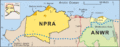
A map of northern Alaska; the dotted line shows the southern boundary of the North Slope. The National Petroleum Reserve–Alaska is to the West, the Arctic National Wildlife Refuge to the east, and Prudhoe Bay is between them.
-
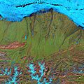
Landsat 7 false-color image of the North Slope. Along the coast, fast ice still clings to the shore in a solid, frozen sheet. At the top of the scene is the drifting sea ice. A dark blue strip of open water, known as a flaw lead, separates the fast ice from the drifting sea ice. The Brooks Range is visible at the bottom. (June 2001)
-
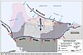
Map from the US Bureau of Land Management showing structures that create the oil fields in Alaska
-
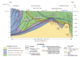
North Slope geologic cross section
-
Geophysical Service Inc. seismic exploration crew, Deadhorse, Alaska, 1981
