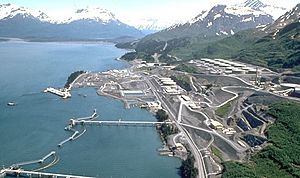
Valdez, Alaska facts for kids
Quick facts for kids
Valdez, Alaska
Suacit
|
|
|---|---|
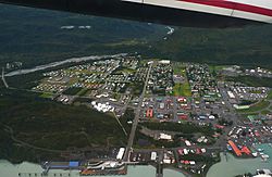
Aerial view showing the townsite, the harbor, Port Valdez, the lower Mineral Creek valley, and Blueberry Hill
|
|
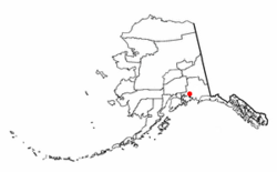
Location of Valdez, Alaska
|
|
| Country | United States |
| State | Alaska |
| Census Area | Chugach |
| Incorporated | June 11, 1901 |
| Area | |
| • Total | 271.91 sq mi (704.24 km2) |
| • Land | 212.69 sq mi (550.86 km2) |
| • Water | 59.22 sq mi (153.37 km2) |
| Elevation | 98 ft (30 m) |
| Population
(2020)
|
|
| • Total | 3,985 |
| • Density | 18.74/sq mi (7.23/km2) |
| Time zone | UTC−9 (Alaska (AKST)) |
| • Summer (DST) | UTC−8 (AKDT) |
| ZIP code |
99686
|
| Area code | 907 |
| FIPS code | 02-82200 |
| GNIS feature ID | 1412465 |
| Website | [1] |
Valdez (say it like val-DEEZ) is a city in Alaska, a state in the United States. In 2020, about 3,985 people lived there. It's one of the bigger cities in a part of Alaska called the Unorganized Borough.
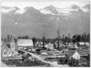
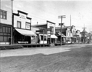
The city got its name in 1790 from a Spanish naval officer. Valdez used to be a Gold Rush town. It sits at the end of Port Valdez on the eastern side of Prince William Sound. The city officially became a city in 1901. It really grew after a road to Fairbanks was built in 1910. Valdez was badly damaged by a huge earthquake in 1964. It is also near where the Exxon Valdez oil spill happened in 1989. Today, Valdez is a very important port in Alaska. It's used for commercial fishing and as a shipping hub. It's also where the Trans-Alaska Pipeline System ends.
Contents
History of Valdez
Spanish Explorers Arrive
The port of Valdez was named in 1790 by a Spanish explorer named Salvador Fidalgo. He named it after a Spanish naval officer, Antonio Valdés y Fernández Bazán.
In 1790, Spain sent expeditions to the Pacific Northwest. Salvador Fidalgo sailed to Alaska. He anchored near what is now Cordova, Alaska. The expedition did not find any signs of Russia being there. They traded with the local native people. On June 3, they landed and Fidalgo put up a large wooden cross. This showed that Spain claimed the land. He named the area "Puerto Córdova." Fidalgo kept exploring the Alaskan coast. On June 15, they found a new port. They named it Puerto Valdés. This was to honor Antonio Valdés y Fernández Bazán. He was a very important government official in Spain.
Later, Spain gave Great Britain rights to use the Pacific Northwest. Spain then gave up its claims to land north of the 42nd parallel to the United States in 1819.
A Town for Gold Miners
In 1898, a trick to get gold miners to come to Valdez led to the town growing. Some steamship companies said that the Valdez Glacier Trail was a better way to reach the Klondike Gold Rush gold fields. They also said miners could find new gold in the Copper River area. Miners who believed this found out they were tricked. The glacier trail was much longer and steeper than they were told. Many men died trying to cross it. They got sick because they didn't have enough supplies during the cold winter.
The town did not really grow until the Richardson Highway was built in 1910. This road connected Valdez and Fairbanks. With a new road and its port that never freezes, Valdez became the main way to bring supplies into interior Alaska. The highway was only open in summer until 1950. After that, it was open all year.
In 1907, a fight between two railroad companies ended Valdez's dream. Valdez wanted to be the railroad link to the Kennicott Copper Mine. This mine had a lot of copper ore. During the fight, one person was killed and several were hurt. The fight happened at the entrance of Keystone Canyon. A half-finished tunnel there shows where the railroad plans ended for Valdez. A different rail line to Kennicott was later built from the city of Cordova.
The 1964 Earthquake
The city of Valdez was badly damaged by the Good Friday earthquake in 1964. The ground under the city turned soft. This caused a huge underwater landslide. A part of the city's shoreline broke off and sank into the sea. This movement of soil under the water caused a local tsunami about 30 feet (9 meters) high. It moved away from the city and down Valdez Bay.
Thirty-two people were on the city's main dock. They were helping to unload a supply ship. All 32 people died when the dock fell into the ocean during the landslide. No one in the main town area died.

People kept living in Valdez for three more years. A new city site was being prepared on more stable ground. It was about 4 miles (6.4 km) away. The United States Army Corps of Engineers oversaw the new construction. They moved 54 houses and buildings by truck to the new spot. This helped to rebuild the city where it is now. The original town site was taken apart, left empty, and later burned down.
In the early 1900s, city leaders had wanted to move Valdez to higher ground. After they were gone, their idea finally came true. The 1964 earthquake was the key event. What is now called "Old Town" was destroyed. The families of the old leaders helped. They formed The Port Valdez Company. They gave 115 acres of land for free. This land was where an old development called "Hazeletville" used to be. This allowed the City of Valdez to rebuild and grow again.
The Trans-Alaska Pipeline
From 1975 to 1977, the Trans-Alaska Pipeline System was built. It carries oil from the Prudhoe Bay oil fields in northern Alaska. The oil goes to a terminal in Valdez. Valdez is the closest port that doesn't freeze. Oil is then loaded onto large tanker ships. Building and running the pipeline and terminal helped Valdez's economy a lot. The first tanker to carry oil from the pipeline was the ARCO Juneau in 1977. It was going to Washington state.
The 1989 Exxon Valdez oil spill happened when the oil tanker Exxon Valdez was leaving the terminal in Valdez. The spill happened at Bligh Reef, about 40 kilometers (25 miles) from Valdez. The oil did not reach Valdez itself. However, it caused great harm to marine life in the areas around it. Cleaning up the oil spill did cause a short-term boost to Valdez's economy.
Avalanches in 2014
On January 24, 2014, a large avalanche happened near Valdez. It was at Mile 16 near Keystone Canyon. This caused the only highway into or out of town to close. The next day, another huge avalanche was triggered by the Alaska Department of Transportation. This made the road even more blocked. The avalanche blocked the Lowe River, creating a lake about half a mile long. This stopped snow removal for almost a week. Locals called this blockage the "Damalanche." News of this event spread across the country. Once the water went down, crews worked hard to clear about 200,000 cubic yards of snow in five days. No one was hurt during this event.
Valdez Geography and Climate
Valdez is located at 61°7′51″N 146°20′54″W / 61.13083°N 146.34833°W. The city covers a total area of about 277.1 square miles (717.7 square kilometers). About 222.0 square miles (575.0 square kilometers) is land. The rest, about 55.1 square miles (142.7 square kilometers), is water.
Valdez is at the end of a deep fjord in the Prince William Sound in Alaska. It is surrounded by the Chugach Mountains. These mountains have many glaciers. Shoup Glacier, nearby, used to provide ice for the town in the early 1900s. Valdez is the northernmost port in North America that stays ice-free all year. The northernmost part of the Pacific temperate rain forests is in Valdez, on Blueberry Hill. The only way to reach Valdez by road is on the Richardson Highway. This highway goes through Thompson Pass and Keystone Canyon before ending in Valdez.
Valdez Climate and Weather
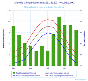
Valdez has a subarctic climate. Its winters are warmer than most places with this climate. But they are not mild enough to be called an oceanic climate.
Valdez is known as the snowiest city in the United States. It gets over 300 inches (762 cm) of snow each year on average. There have been times when more than 100 inches (254 cm) of snow fell in a single month.
| Climate data for Valdez, Alaska (1991–2020 normals, extremes 1917–present) | |||||||||||||
|---|---|---|---|---|---|---|---|---|---|---|---|---|---|
| Month | Jan | Feb | Mar | Apr | May | Jun | Jul | Aug | Sep | Oct | Nov | Dec | Year |
| Record high °F (°C) | 55 (13) |
59 (15) |
57 (14) |
69 (21) |
79 (26) |
90 (32) |
85 (29) |
84 (29) |
75 (24) |
69 (21) |
59 (15) |
54 (12) |
90 (32) |
| Mean maximum °F (°C) | 40.1 (4.5) |
41.2 (5.1) |
46.6 (8.1) |
57.1 (13.9) |
68.4 (20.2) |
75.1 (23.9) |
76.3 (24.6) |
74.8 (23.8) |
65.7 (18.7) |
55.0 (12.8) |
43.6 (6.4) |
41.0 (5.0) |
78.9 (26.1) |
| Mean daily maximum °F (°C) | 28.7 (−1.8) |
31.9 (−0.1) |
36.7 (2.6) |
46.4 (8.0) |
55.6 (13.1) |
62.5 (16.9) |
64.1 (17.8) |
62.0 (16.7) |
55.0 (12.8) |
44.9 (7.2) |
33.9 (1.1) |
30.7 (−0.7) |
46.0 (7.8) |
| Daily mean °F (°C) | 23.9 (−4.5) |
26.7 (−2.9) |
29.9 (−1.2) |
39.2 (4.0) |
47.7 (8.7) |
54.4 (12.4) |
56.6 (13.7) |
54.5 (12.5) |
48.3 (9.1) |
39.5 (4.2) |
29.4 (−1.4) |
26.2 (−3.2) |
39.7 (4.3) |
| Mean daily minimum °F (°C) | 19.1 (−7.2) |
21.4 (−5.9) |
23.0 (−5.0) |
31.9 (−0.1) |
39.8 (4.3) |
46.3 (7.9) |
49.1 (9.5) |
46.9 (8.3) |
41.6 (5.3) |
34.1 (1.2) |
24.9 (−3.9) |
21.8 (−5.7) |
33.3 (0.7) |
| Mean minimum °F (°C) | 2.8 (−16.2) |
6.9 (−13.9) |
10.0 (−12.2) |
20.8 (−6.2) |
31.9 (−0.1) |
39.2 (4.0) |
43.9 (6.6) |
40.3 (4.6) |
31.6 (−0.2) |
23.0 (−5.0) |
12.4 (−10.9) |
7.2 (−13.8) |
−0.5 (−18.1) |
| Record low °F (°C) | −24 (−31) |
−28 (−33) |
−11 (−24) |
0 (−18) |
13 (−11) |
27 (−3) |
33 (1) |
29 (−2) |
14 (−10) |
5 (−15) |
−10 (−23) |
−18 (−28) |
−28 (−33) |
| Average precipitation inches (mm) | 6.56 (167) |
5.92 (150) |
4.10 (104) |
3.37 (86) |
3.02 (77) |
2.44 (62) |
3.87 (98) |
7.00 (178) |
9.76 (248) |
7.98 (203) |
6.14 (156) |
7.74 (197) |
67.90 (1,725) |
| Average snowfall inches (cm) | 66.6 (169) |
63.4 (161) |
45.8 (116) |
22.3 (57) |
3.4 (8.6) |
0.0 (0.0) |
0.0 (0.0) |
0.0 (0.0) |
0.7 (1.8) |
9.1 (23) |
43.5 (110) |
70.5 (179) |
325.3 (826) |
| Average precipitation days (≥ 0.01 in) | 16.3 | 15.3 | 13.9 | 14.3 | 15.0 | 13.8 | 18.0 | 18.4 | 20.9 | 19.3 | 15.5 | 17.3 | 198.0 |
| Average snowy days (≥ 0.1 in) | 15.6 | 14.3 | 13.0 | 6.2 | 1.4 | 0.0 | 0.0 | 0.0 | 0.3 | 4.7 | 12.9 | 16.0 | 84.4 |
| Average relative humidity (%) | 77.6 | 72.7 | 72.9 | 72.5 | 75.2 | 78.5 | 83.0 | 84.9 | 84.2 | 78.5 | 74.0 | 77.1 | 77.6 |
| Average dew point °F (°C) | 18.1 (−7.7) |
16.5 (−8.6) |
22.5 (−5.3) |
28.2 (−2.1) |
37.6 (3.1) |
44.4 (6.9) |
48.9 (9.4) |
47.8 (8.8) |
41.7 (5.4) |
31.5 (−0.3) |
19.8 (−6.8) |
18.1 (−7.7) |
31.3 (−0.4) |
| Source: NOAA | |||||||||||||
People of Valdez
| Historical population | |||
|---|---|---|---|
| Census | Pop. | %± | |
| 1900 | 315 | — | |
| 1910 | 810 | 157.1% | |
| 1920 | 466 | −42.5% | |
| 1930 | 442 | −5.2% | |
| 1940 | 529 | 19.7% | |
| 1950 | 554 | 4.7% | |
| 1960 | 555 | 0.2% | |
| 1970 | 1,005 | 81.1% | |
| 1980 | 3,079 | 206.4% | |
| 1990 | 4,068 | 32.1% | |
| 2000 | 4,036 | −0.8% | |
| 2010 | 3,976 | −1.5% | |
| 2020 | 3,985 | 0.2% | |
| U.S. Decennial Census | |||
Valdez first appeared in the U.S. Census in 1900. It was called "Valdes" then. It officially became Valdez in 1901. It has been in every census since. The original town site was moved in 1967. This happened after the 1964 earthquake. The new site is still within the city limits today.
In 2020, there were 3,985 people living in Valdez. Most people were White (75.7%). About 7.8% were Native American or Alaska Native. About 2.6% were Asian. About 10.3% were from two or more races. About 6.8% of people were Hispanic or Latino.
There were 1,610 households in the city. The average age of people was 40 years old. The average income for a household was $99,151. About 4.4% of the people lived below the poverty line. This included 7.6% of those under 18.
Valdez Economy and Transportation
Valdez is a fishing port. People go there for both commercial fishing and sport fishing. Goods are shipped through Valdez to other parts of Alaska. Many tourists visit Valdez to see marine life and glaciers. They also enjoy deep-sea fishing and heli-skiing. Oil from the Trans-Alaska Pipeline System is loaded onto ships at the Valdez oil terminal.
Alyeska Pipeline Service Company is one of the biggest employers in Valdez.
Valdez is connected to interior Alaska by the Richardson Highway. It is also a stop for the Alaska Marine Highway ferry system. Just north of Valdez on the highway is Thompson Pass. This pass has amazing waterfalls and glaciers right next to the road. Thompson Pass is also known for difficult driving in winter.
The Valdez Airport, also called Pioneer Field, has regular flights with Ravn Alaska.
Valdez hosted the World Extreme Skiing Championship (WESC) in the early 1990s.
Media and Culture in Valdez
Even though it's a small city, Valdez used to have two weekly newspapers. These were the Valdez Star and the Valdez Vanguard. In 2004, the Star bought the Vanguard.
Valdez also has radio stations like KCHU, KVAK, and KVAK-FM.
Valdez is home to the Last Frontier Theatre Conference. This event is hosted by the Prince William Sound College. Each year, playwrights and actors from all over the United States come to this conference.
The movie On Deadly Ground (1994) was filmed near Worthington Glacier. Parts were also filmed at the Valdez Civic Center and Valdez Airport. Other scenes were shot 30 miles (48 km) outside Valdez in Thompson Pass.
Valdez Oil Terminal
The Valdez Marine Terminal is an oil port in Valdez. It is at the southern end of the Alaska Pipeline. The Exxon Valdez oil tanker left from this terminal just before its oil spill.
There are 14 large tanks at the terminal that store crude oil. On average, three to five oil tankers leave the terminal each week. Since the pipeline started working in 1976, more than 19,000 tankers full of oil have left the terminal.
The terminal has 2 places where ships can load oil.
Famous People from Valdez
- Neva Egan (1914–2011), the first First Lady of Alaska (1959–1966, 1970–1974)
- William A. Egan (1914–1984), the first Governor of Alaska (1959–1966, 1970–1974)
- Margaret Keenan Harrais (1872–1964), a United States Commissioner in Valdez. After Alaska became a state, she became a deputy judge there.
- Robert Campbell Reeve (1902–1980), a pilot based in Valdez. He started Reeve Aleutian Airways.
- Bill Walker (born 1951), a former Governor of Alaska
- Ed Walker (1917–2011), a former member of the Valdez city council. He was one of the last surviving members of Castner's Cutthroats.
See also
 In Spanish: Valdez (Alaska) para niños
 | Toni Morrison |
 | Barack Obama |
 | Martin Luther King Jr. |
 | Ralph Bunche |


