
Mount Francis (Alaska) facts for kids
Quick facts for kids Mount Francis |
|
|---|---|

Mount Francis, north aspect
|
|
| Highest point | |
| Elevation | 5,426 ft (1,654 m) |
| Prominence | 1,654 ft (504 m) |
| Isolation | 5.9 mi (9.5 km) |
| Geography | |

Mount Francis
Location in Alaska
|
|
| Location | Valdez-Cordova Borough Alaska, United States |
| Parent range | Chugach Mountains |
| Topo map | USGS Valdez A-6 |
Mount Francis is a tall mountain in Alaska, United States. It stands at about 5,426 feet (1,654 meters) high and is covered in glaciers. This mountain is part of the Chugach Mountains.
You can find Mount Francis about 6 miles (10 km) southeast of a town called Valdez. It's also near Hogback Ridge and Meteorite Mountain. Captain William R. Abercrombie named the mountain in 1898. He was on an adventure to find a path from the coast of Alaska to the famous Klondike gold region. The water from the melting glaciers on Mount Francis flows into streams that lead to the Lowe River, and then into Prince William Sound.
Contents
Understanding the Climate at Mount Francis
Mount Francis is in a very cold part of the world. It has a subarctic climate. This means the winters are very long, cold, and snowy. The summers are cool, but not warm.
How Weather Forms Around Mount Francis
Weather systems often come from the Gulf of Alaska. When they hit the tall Chugach Mountains, the air is forced to rise. This process is called orographic lift. As the air goes higher, it cools down and creates a lot of rain and snow.
Temperatures and Best Visiting Times
During winter, temperatures on Mount Francis can drop below -20 °C (-4 °F). With wind, it can feel even colder, sometimes below -30 °C (-22 °F)! If you want to see Mount Francis or climb it, the best time to visit is usually in May or June. The weather is much nicer then.
Images for kids
-
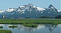
Mt. Francis with Sugarloaf Mountain (right)
-
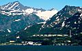
Mt. Francis (upper left) and pipeline terminal


