
Hogback Ridge facts for kids
Quick facts for kids Hogback Ridge |
|
|---|---|

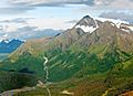
Hogback's east aspect, from Thompson Pass
|
|
| Highest point | |
| Elevation | 6,135 ft (1,870 m) |
| Prominence | 2,198 ft (670 m) |
| Isolation | 4.35 mi (7.00 km) |
| Parent peak | East Peak |
| Geography | |

Hogback Ridge
Location in Alaska
|
|
| Location | Valdez-Cordova Borough Alaska, United States |
| Parent range | Chugach Mountains |
| Topo map | USGS Valdez A-6 |
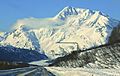
Hogback Ridge is a large, icy mountain ridge in Alaska. It stands about 6,135 feet (1,870 meters) tall. This impressive landform is part of the Chugach Mountains.
You can find Hogback Ridge about 9 miles (14 km) east of the town of Valdez. It's also 9 miles (14 km) west of Thompson Pass. The Richardson Highway runs along the southern base of the mountain.
Naming Hogback Ridge
This mountain feature gets its name from the Hogback Glacier. This glacier is located on the northern slopes of the ridge. Captain William R. Abercrombie named the glacier in 1898. He was leading an expedition at the time. His team was looking for a route from the coast of Alaska to the Klondike region.
Water and Waterfalls
Water from the melting glaciers on Hogback Ridge flows into nearby rivers. This water eventually drains into the Lowe River. The Lowe River then empties into Prince William Sound.
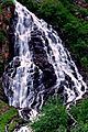
A famous waterfall called Horsetail Falls gets its water from Hogback Ridge. This beautiful waterfall is located in Keystone Canyon. Its source is on the south side of the mountain.
Climate Around Hogback Ridge
Hogback Ridge is in a subarctic climate zone. This means the area has very long, cold, and snowy winters. Summers are usually cool. Temperatures can drop below −20 °C (–4 °F). With wind, it can feel even colder, sometimes below −30 °C (–22 °F).
This cold climate helps to support several glaciers on the mountain. These include the Corbin, Keystone, and Hogback Glaciers. The best time to visit Hogback Ridge for viewing or climbing is usually from May through June. The weather during these months is often more favorable.
Images for kids
-
Hogback Ridge
-
Hogback Ridge in winter
-
Horsetail Falls


