Eastern North Carolina facts for kids
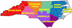
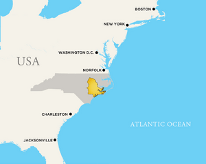
Eastern North Carolina (often called ENC) is a large area in the eastern part of North Carolina, United States. It's known for its flat land, which is part of the state's Coastal Plain. This region includes areas like the Sandhills, the Lower Cape Fear (around Wilmington), the Crystal Coast, the Inner Banks, and the Outer Banks. It's made up of the 41 easternmost counties in North Carolina. Some important cities here are Greenville, Jacksonville, Wilmington, Rocky Mount, and New Bern, which was North Carolina's first capital city.
In 1993, the state government created groups to help the economy grow in different regions. Three of these groups focus on Eastern North Carolina: the Northeast North Carolina Commission, North Carolina East Alliance, and North Carolina's Southeast Commission. These groups work to improve job opportunities and bring new businesses to the area. For example, the North Carolina East Alliance helps train people for jobs to create a stronger local workforce.
Eastern North Carolina is located east of the Piedmont region and west of the Atlantic Ocean. While it has some cities, it doesn't have many very large urban centers. Fayetteville is the biggest city in the region, followed by Wilmington and Greenville. Greenville is also close to the center of the region.
Contents
Geography
Eastern North Carolina generally includes the 41 counties that are east of or crossed by Interstate 95. I-95 is a major highway that runs along the East Coast of the USA. This highway, along with Interstate 40, makes it easy to travel throughout the region and connect to other parts of the state and country. Geographically, the region is part of the Coastal Plain. It can be divided into three main sections: the Southeast, the Inner Banks, and the Outer Banks.
History
Long ago, Native American tribes, especially the Tuscarora people, lived along the coast of North Carolina. Eastern North Carolina is also famous for Roanoke Island, where the first English settlers tried to build a colony in the New World.
During the time when America was still a colony, Eastern North Carolina was the most important part of the state for government and business. Early towns like Bath, Beaufort, Edenton, and New Bern were very important. The economy back then relied on farming cash crops, fishing, and making turpentine from trees. Settlers from England, Scotland, Switzerland, and Germany came to live here. This region was also a hiding place for pirates, including the famous Blackbeard! The city of New Bern was founded in 1710 by settlers from Germany and later became the capital of the colony. However, by the late 1700s, the center of power and population shifted to the Piedmont region of the state.
After the American Revolution, more people moved to the western and Piedmont parts of North Carolina. This led to changes in the Constitution of North Carolina in 1835, including allowing people to vote for the governor.
Education
Four-year Universities
Eastern North Carolina has many colleges and universities. There are five public universities and seven private ones. The largest is East Carolina University, which is a major research university. The other public universities are Elizabeth City State University, Fayetteville State University, University of North Carolina at Pembroke, and University of North Carolina at Wilmington. The private colleges include Barton College, Campbell University, Chowan University, Methodist University, University of Mount Olive, North Carolina Wesleyan College, and Mid-Atlantic Christian University.
Community Colleges
The region also has 23 community colleges. These two-year colleges help students learn skills for jobs or prepare to transfer to a four-year university. They include:
- Beaufort County Community College
- Bladen Community College
- Brunswick Community College
- Cape Fear Community College
- Carteret Community College
- College of the Albemarle
- Coastal Carolina Community College
- Craven Community College
- Edgecombe Community College
- Fayetteville Technical Community College
- James Sprunt Community College
- Johnston Community College
- Lenoir Community College
- Roanoke-Chowan Community College
- Martin Community College
- Nash Community College
- Pamlico Community College
- Pitt Community College
- Sampson Community College
- Sandhills Community College
- Southeastern Community College
- Wayne Community College
- Wilson Community College
Many of these community colleges offer special programs to train people for jobs in the region. For example, they have degrees in aerospace, medical device manufacturing, food processing, and boat building. This helps create a skilled workforce for local industries.
Transportation
Eastern North Carolina has a good transportation network, including major highways, railroads, and airports.
Road Transportation
- Interstate 95 forms the western edge of the region, passing through cities like Rocky Mount and Fayetteville.
- Interstate 40 serves the southeastern part, connecting areas from Wayne County to Wilmington.
- I-795 is a main highway between Wilson and Goldsboro.
- Many U.S. Routes also cross the region, like U.S. 17 (which goes through Washington, New Bern, and Wilmington) and U.S. 70 (connecting Selma, Goldsboro, Kinston, and Morehead City).
- U.S. 64 goes from Rocky Mount all the way to Nags Head on the Outer Banks.
- These roads make it easy for people to travel and for businesses to move their goods across the state and country.
Rail Transportation
Railroads like CSX and Norfolk Southern Railway serve industries in the region, helping to transport goods. For passengers, Amtrak has train stations in cities like Rocky Mount, Wilson, Selma, and Fayetteville.
Air Transportation
Wilmington International Airport is located in Eastern North Carolina. The Raleigh-Durham International Airport (RDU) is also a short drive away. These airports offer flights to major cities like Charlotte, Atlanta, and Philadelphia. There are also sixteen smaller regional airports for general aviation.
Global Transpark
The North Carolina Global TransPark (GTP) is a very large industrial park, covering 2,500 acres. It's designed for businesses that need to move goods by air, road, or rail.
Ports
Eastern North Carolina has two important deep-water ports: one in Morehead City and another in Wilmington. These ports can handle large ships carrying all kinds of cargo, from containers to cars and military equipment. There's also a large port just north of the state line in Norfolk, Virginia, that serves the region.
Socio-economic
Eastern North Carolina faces some economic challenges. About 21% of people in this region live in poverty. Many manufacturing jobs, like those in textile factories, have moved overseas, which has led to higher unemployment in some areas. However, some parts of the region are growing quickly. For example, Greenville is expanding rapidly because of East Carolina University and its medical facilities. Fleet Readiness Center East at Marine Corps Air Station Cherry Point is also a very large employer, providing many jobs in the eastern part of the state.
Topography
Eastern North Carolina is part of the coastal plain, so the land is mostly flat. This flat land is mainly used for farming. The unique Outer Banks are a chain of barrier islands along the coast, which are quite rare and beautiful.
Area
Eastern North Carolina generally includes 41 counties, covering about 9,700 square miles (25,000 square kilometers). The counties usually included are:
- Bertie County
- Beaufort County
- Bladen County
- Brunswick County
- Camden County
- Carteret County
- Chowan County
- Columbus County
- Craven County
- Cumberland County
- Currituck County
- Dare County
- Duplin County
- Edgecombe County
- Gates County
- Greene County
- Halifax County
- Harnett County
- Hertford County
- Hoke County
- Hyde County
- Johnston County
- Jones County
- Lenoir County
- Martin County
- Nash County
- New Hanover County
- Northampton County
- Onslow County
- Pamlico County
- Pasquotank County
- Pender County
- Perquimans County
- Pitt County
- Robeson County
- Sampson County
- Scotland County
- Tyrrell County
- Washington County
- Wayne County
- Wilson County
Cities and Towns
Here are some of the communities in Eastern North Carolina:
Over 50,000 in Population
Fewer than 50,000 Population
- Ahoskie
- Alliance
- Angier
- Arapahoe
- Atkinson
- Atlantic Beach
- Aulander
- Aurora
- Autryville
- Ayden
- Bald Head Island
- Bath
- Bayboro
- Bear Grass
- Beaufort
- Belhaven
- Belville
- Bethel
- Beulaville
- Black Creek
- Bladenboro
- Bogue
- Boiling Spring Lakes
- Bolivia
- Bridgeton
- Burgaw
- Calabash
- Cape Carteret
- Carolina Beach
- Carolina Shores
- Caswell Beach
- Chadbourn
- Chocowinity
- Columbia
- Edenton
- Elizabeth City
- Elizabethtown
- Elm City
- Emerald Isle
- Faison
- Falkland
- Farmville
- Fremont
- Garland
- Gatesville
- Goldsboro
- Grifton
- Grimesland
- Kinston
- Laurinburg
- Lewiston
- Lumberton
- Morehead City
- New Bern
- Newport
- Pantego
- Roanoke Rapids
- Snow Hill
- Sneads Ferry
- Tarboro
- Williamston
- Wilson
 | Valerie Thomas |
 | Frederick McKinley Jones |
 | George Edward Alcorn Jr. |
 | Thomas Mensah |


