Elizabethtown, North Carolina facts for kids
Quick facts for kids
Elizabethtown, North Carolina
|
||
|---|---|---|

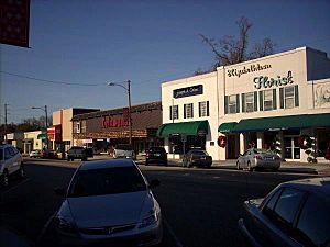
A view of Broad Street
|
||
|
||

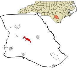
Location in Bladen County and the state of North Carolina.
|
||
| Country | ||
| State | ||
| County | Bladen | |
| Area | ||
| • Total | 5.11 sq mi (13.24 km2) | |
| • Land | 5.07 sq mi (13.13 km2) | |
| • Water | 0.04 sq mi (0.11 km2) | |
| Elevation | 118 ft (36 m) | |
| Population
(2020)
|
||
| • Total | 3,296 | |
| • Density | 650.23/sq mi (251.05/km2) | |
| Time zone | UTC-5 (Eastern (EST)) | |
| • Summer (DST) | UTC-4 (EDT) | |
| ZIP code |
28337
|
|
| Area codes | 910, 472 | |
| FIPS code | 37-20600 | |
| GNIS feature ID | 2406434 | |
Elizabethtown is a town located in Bladen County, North Carolina, in the United States. It's an important place because it's the county seat of Bladen County. This means it's where the main government offices for the county are. In 2020, about 3,296 people lived here.
Contents
History of Elizabethtown
How Elizabethtown Got Its Name
The town of Elizabethtown has an interesting story behind its name. Some people believe it was named after Elizabeth, who was the wife of a person named George Carteret. Others think it was named for someone a local landowner cared about.
Historic Buildings in Town
Elizabethtown is home to some old and important buildings. Two of these, the Mt. Horeb Presbyterian Church and Cemetery and the Trinity Methodist Church, are listed on the National Register of Historic Places. This means they are recognized as special places that are worth preserving for future generations.
Geography of Elizabethtown
Size and Location
Elizabethtown covers an area of about 12.1 square kilometers (or 5.11 square miles). Most of this area is land, with a small part being water.
Local Waterways
A creek called Browns Creek flows through the southern part of Elizabethtown. This creek eventually flows into the larger Cape Fear River.
People of Elizabethtown
Population Over Time
The number of people living in Elizabethtown has changed quite a bit over the years. Here's a quick look at how the population has grown and shrunk:
| Historical population | |||
|---|---|---|---|
| Census | Pop. | %± | |
| 1870 | 62 | — | |
| 1880 | 212 | 241.9% | |
| 1900 | 144 | — | |
| 1910 | 117 | −18.7% | |
| 1920 | 335 | 186.3% | |
| 1930 | 765 | 128.4% | |
| 1940 | 1,123 | 46.8% | |
| 1950 | 1,611 | 43.5% | |
| 1960 | 1,625 | 0.9% | |
| 1970 | 1,418 | −12.7% | |
| 1980 | 3,551 | 150.4% | |
| 1990 | 3,704 | 4.3% | |
| 2000 | 3,698 | −0.2% | |
| 2010 | 3,583 | −3.1% | |
| 2020 | 3,296 | −8.0% | |
| U.S. Decennial Census | |||
Who Lives in Elizabethtown (2020 Census)
According to the 2020 United States Census, there were 3,296 people living in Elizabethtown. These people made up 1,482 households and 750 families. The census also showed the different groups of people living in the town:
| Race | Number of People | Percentage |
|---|---|---|
| White | 1,488 | 45.15% |
| Black or African American | 1,530 | 46.42% |
| Native American | 25 | 0.76% |
| Asian | 10 | 0.3% |
| Pacific Islander | 6 | 0.03% |
| Other/Mixed | 104 | 3.16% |
| Hispanic or Latino | 139 | 4.22% |
See also
 In Spanish: Elizabethtown (Carolina del Norte) para niños
 | Madam C. J. Walker |
 | Janet Emerson Bashen |
 | Annie Turnbo Malone |
 | Maggie L. Walker |


