Jones County, North Carolina facts for kids
Quick facts for kids
Jones County
|
|||||
|---|---|---|---|---|---|
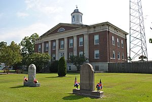
Jones County Courthouse
|
|||||
|
|||||
| Motto(s):
"Small Living. Big Opportunity. Ready to Grow."
|
|||||
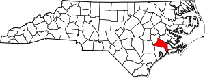
Location within the U.S. state of North Carolina
|
|||||
 North Carolina's location within the U.S. |
|||||
| Country | |||||
| State | |||||
| Founded | 1779 | ||||
| Named for | Willie Jones | ||||
| Seat | Trenton | ||||
| Largest community | Maysville | ||||
| Area | |||||
| • Total | 473.72 sq mi (1,226.9 km2) | ||||
| • Land | 471.39 sq mi (1,220.9 km2) | ||||
| • Water | 2.33 sq mi (6.0 km2) 0.49% | ||||
| Population
(2020)
|
|||||
| • Total | 9,172 | ||||
| • Estimate
(2023)
|
9,401 | ||||
| • Density | 19.59/sq mi (7.56/km2) | ||||
| Time zone | UTC−5 (Eastern) | ||||
| • Summer (DST) | UTC−4 (EDT) | ||||
| Congressional district | 3rd | ||||
Jones County is a county in the state of North Carolina, USA. In 2020, about 9,172 people lived there. This makes it one of the least populated counties in North Carolina.
The main town and government center is Trenton. Jones County is part of the New Bern area.
There are three main towns in Jones County: Pollocksville, Trenton, and Maysville. Two important roads, US 17 and US 70, pass through the county.
Contents
History of Jones County
Before European settlers arrived, the Tuscarora Native Americans lived in the area that is now Jones County. In the early 1700s, German and Swiss settlers moved here.
Jones County was created in 1779 from part of Craven County. It was named after Willie Jones. He was a leader during the American Revolution. He also led the North Carolina Committee of Safety during the war.
In 1784, the town of Trenton became the county seat. This means it was chosen as the main town for the county's government.
The county's economy mostly depended on farming, especially tobacco, and cutting down trees for wood. In 2004, the population went over 10,000 people for a short time. However, by 2020, it had gone down to 9,172 people.
Geography of Jones County
Jones County covers about 473.72 square miles (1,227 square kilometers). Most of this area is land (471.39 square miles), and a small part is water (2.33 square miles). The county has a lot of farms and swampy areas.
National Protected Areas
Some parts of these special natural areas are found in Jones County:
- Catfish Lake South Wilderness
- Croatan National Forest
- Pond Pine Wilderness
State and Local Protected Areas
These protected areas are also partly in Jones County:
- Croatan Game Land
- Hofmann Forest
Major Water Bodies
Important rivers and lakes in Jones County include:
- Beaverdam Creek
- Catfish Lake
- Trent River
Neighboring Counties
Jones County shares borders with these counties:
- Craven County – to the northeast
- Carteret County – to the southeast
- Onslow County – to the south
- Duplin County – to the west
- Lenoir County – to the northwest
Major Roads
These important highways run through Jones County:

 Future I-42
 US 17
US 17 US 70
US 70 US 258
 NC 41
NC 41 NC 58
NC 58
Important Facilities
- Marine Corps Outlying Field Oak Grove is a small military base near Pollocksville.
People of Jones County
In 2020, there were 9,172 people living in Jones County. There were 4,045 households and 2,644 families.
Most people in Jones County are White (about 63%). About 28% are Black or African American. Other groups make up smaller parts of the population.
Fun Things to Do in Jones County
Jones County is about 8 miles (13 kilometers) west of the Atlantic Ocean. The county has waterfront areas along the Trent and White Oak rivers. Part of the Great Dover Swamp is also within the county.
Many people enjoy boating and fishing in the rivers. You can also go camping at the 17 Family Campground near Maysville. The Croatan National Forest has hiking trails and places to see wildlife. The wide-open fields and forests are great for outdoor activities.
Communities in Jones County
Towns
- Maysville (This is the largest town. Part of it is also in Onslow County.)
- Pollocksville
- Trenton (This is where the county government is located.)
Unincorporated Communities
These are smaller communities that are not officially towns:
Townships
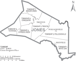
The county is divided into seven areas called townships. They have numbers and names:
- 1 (White Oak)
- 2 (Pollocksville)
- 3 (Trenton)
- 4 (Cypress Creek)
- 5 (Tuckahoe)
- 6 (Chinquapin)
- 7 (Beaver Creek)
See also
 In Spanish: Condado de Jones (Carolina del Norte) para niños
 | Selma Burke |
 | Pauline Powell Burns |
 | Frederick J. Brown |
 | Robert Blackburn |


