Maysville, North Carolina facts for kids
Quick facts for kids
Maysville, North Carolina
|
||
|---|---|---|

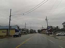
U.S. Route 17 in Maysville, March 2015
|
||
|
||
| Motto(s):
"Naturally Welcoming"
|
||

Location of Maysville, North Carolina
|
||
| Country | United States | |
| State | North Carolina | |
| County | Jones, Onslow | |
| Area | ||
| • Total | 0.86 sq mi (2.22 km2) | |
| • Land | 0.86 sq mi (2.22 km2) | |
| • Water | 0.00 sq mi (0.00 km2) | |
| Elevation | 39 ft (12 m) | |
| Population
(2020)
|
||
| • Total | 818 | |
| • Density | 955.61/sq mi (368.83/km2) | |
| Time zone | UTC-5 (Eastern (EST)) | |
| • Summer (DST) | UTC-4 (EDT) | |
| ZIP code |
28555
|
|
| Area codes | 910, 472 | |
| FIPS code | 37-42100 | |
| GNIS feature ID | 2406118 | |
Maysville is a small town in Jones County, North Carolina, in the United States. In 2020, about 818 people lived there. It is part of the larger New Bern area. A famous baseball player, Louie Meadows, used to live in Maysville.
Contents
Where Did Maysville Get Its Name?
Maysville got its name from one of the first people who settled there a long time ago.
Exploring Maysville's Location and Surroundings
Maysville is located in the southeastern part of Jones County. A main road, U.S. Route 17, goes right through the middle of town. This road leads north about 21 miles (34 km) to New Bern. It also goes southwest about 15 miles (24 km) to Jacksonville.
Another road, North Carolina Highway 58, heads southeast from Maysville. It takes you about 20 miles (32 km) to Emerald Isle. Emerald Isle is a town right on the Atlantic coast.
Land and Water Around Maysville
The town of Maysville covers an area of about 0.69 square miles (1.8 km2). All of this area is land. The Croatan National Forest is located right next to the eastern side of Maysville. The White Oak River flows past the southern edge of the town.
Maysville's Population Over Time
| Historical population | |||
|---|---|---|---|
| Census | Pop. | %± | |
| 1900 | 98 | — | |
| 1910 | 345 | 252.0% | |
| 1920 | 536 | 55.4% | |
| 1930 | 797 | 48.7% | |
| 1940 | 732 | −8.2% | |
| 1950 | 818 | 11.7% | |
| 1960 | 892 | 9.0% | |
| 1970 | 912 | 2.2% | |
| 1980 | 877 | −3.8% | |
| 1990 | 892 | 1.7% | |
| 2000 | 1,002 | 12.3% | |
| 2010 | 1,019 | 1.7% | |
| 2020 | 818 | −19.7% | |
| U.S. Decennial Census | |||
The number of people living in Maysville has changed over the years. In 1900, only 98 people lived there. The population grew quite a bit by 2010, reaching over 1,000 people. By 2020, the population was 818.
Who Lives in Maysville? (2020 Census)
According to the 2020 United States census, 818 people lived in Maysville. There were 401 households, which are like homes or families living together. Out of these, 263 were families. The town is home to people from many different backgrounds.
Schools in Maysville
- Maysville Elementary School
See also
 In Spanish: Maysville (Carolina del Norte) para niños
 | Leon Lynch |
 | Milton P. Webster |
 | Ferdinand Smith |


