
Emerald Isle, North Carolina facts for kids
Quick facts for kids
Emerald Isle, North Carolina
|
|||
|---|---|---|---|
_6.jpg)
Emerald Isle shoreline
|
|||
|
|||
| Motto(s):
Nice Matters!
|
|||

Location of Emerald Isle, North Carolina
|
|||
| Country | United States | ||
| State | North Carolina | ||
| County | Carteret | ||
| Area | |||
| • Total | 5.01 sq mi (12.98 km2) | ||
| • Land | 4.92 sq mi (12.75 km2) | ||
| • Water | 0.09 sq mi (0.23 km2) | ||
| Elevation | 16 ft (5 m) | ||
| Population
(2020)
|
|||
| • Total | 3,847 | ||
| • Density | 781.43/sq mi (301.70/km2) | ||
| Time zone | UTC-5 (Eastern (EST)) | ||
| • Summer (DST) | UTC-4 (EDT) | ||
| ZIP code |
28594
|
||
| Area code(s) | 252 | ||
| FIPS code | 37-21160 | ||
| GNIS feature ID | 2406448 | ||


Emerald Isle is a town located in Carteret County, North Carolina, United States. It is part of a beautiful coastal area known as the Crystal Coast. The town sits entirely on a long, narrow island called Bogue Banks.
While only about 3,847 people live there all year round (according to the 2020 census), Emerald Isle becomes a very popular vacation spot in the summer. During this time, as many as 50,000 tourists visit each week! They fill up the many rental homes and condos along the oceanfront.
Emerald Isle is known for its friendly, family-oriented atmosphere. You'll find many different types of homes, duplexes, and condominiums lining the beach. The town has also worked on projects to keep its beaches healthy, like adding sand to fight erosion.
Contents
A Look Back in Time: History of Emerald Isle
For a very long time, from about 1 AD up until the time when Europeans first settled in America, Native American tribes lived in the area that is now Emerald Isle. Later, a small number of whalers and fishermen made their homes here.
Early Plans for a Resort
In the 1920s, a man named Henry Fort owned the beaches and land around Emerald Isle. He had a big dream to build a huge summer resort and tourist attraction. Mr. Fort worked with people who develop land, but his plans never came true. After he passed away, his daughter, Anita Maulick, inherited the land.
How the Island Was Divided
In 1951, seven people bought the 12-mile (19 km) stretch of island from Anita Maulick for $350,000. They decided to divide Emerald Isle into 54 sections, each about 1,000 feet (300 m) wide, stretching from the ocean to the sound. The new owners chose their sections by drawing names from a hat.
They wanted Emerald Isle to be a place for families. Because of this, they decided to limit how much land could be used for businesses and mobile homes. Only five sections were set aside for each of these uses.
Connecting to the Mainland
In 1960, a ferry service started, making it easier for people to reach the beaches of Bogue Banks, including Emerald Isle. This helped more visitors come to the island.
A big change happened in 1971 when the Cameron Langston Bridge opened. This bridge connected Cedar Point on the mainland to the western end of Bogue Banks and Emerald Isle. The bridge crosses the Intracoastal Waterway and offers amazing views of Bogue Sound and Bogue Banks. The opening of this bridge led to a lot more building and growth on the island.
Emerald Isle is still a very popular place for families to vacation. It's also known for great fishing and a lot of different marine life. Its beaches are a special place for sea turtles to lay their eggs, and these turtles are protected by law.
Exploring the Land: Geography of Emerald Isle
Emerald Isle is located in the southwestern part of Carteret County. It sits at the western end of Bogue Banks, which is a barrier island. A barrier island is a long, narrow island that runs parallel to the coastline, protecting the mainland from ocean storms.
To the south of Emerald Isle is the huge Atlantic Ocean. To the north, you'll find Bogue Sound, which is a body of water that separates the island from the mainland of North Carolina. The town stretches all the way to the western tip of the island, ending at Bogue Inlet. To the east, Emerald Isle shares a border with the town of Indian Beach.
The town covers a total area of about 5.01 square miles (13.0 km2). Most of this area, about 4.92 square miles (12.7 km2), is land. A smaller part, about 0.09 square miles (0.23 km2), is water.
Who Lives Here: Population Information
The word "demographics" refers to information about the people who live in a place, like how many there are and their ages or backgrounds.
Population Growth Over Time
| Year | Population |
|---|---|
| 1960 | 14 |
| 1970 | 122 |
| 1980 | 865 |
| 1990 | 2434 |
| 2000 | 3488 |
| 2010 | 3655 |
| 2020 | 3847 |
The population of Emerald Isle has grown quite a lot over the years. In 1960, only 14 people lived there! By 2020, the number had grown to 3,847 people.
Emerald Isle in 2020
According to the 2020 United States census, there were 3,847 people living in Emerald Isle. These people made up 1,769 households, and 1,188 of these were families. Most of the residents identified as White (non-Hispanic), making up about 92.15% of the population.
See also
 In Spanish: Emerald Isle (Carolina del Norte) para niños
Images for kids
-
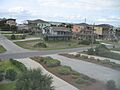
View of an Emerald Isle neighborhood.
-
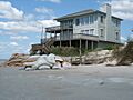
The beach has partially eroded at the western end of Emerald Isle.


