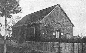
Bath, North Carolina facts for kids
Quick facts for kids
Bath, North Carolina
|
|
|---|---|
| Town of Bath | |
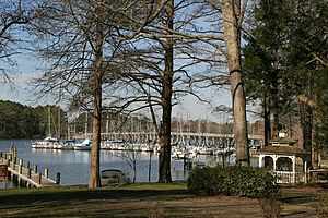
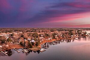
Bath Creek and Marina
|
|
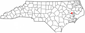
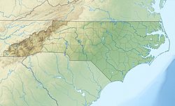
Location of Bath, North Carolina
|
|
| Country | |
| State | |
| County | Beaufort |
| Chartered | March 8, 1705 |
| Named for | Bath, England |
| Government | |
| • Type | Council–Manager |
| Area | |
| • Total | 0.92 sq mi (2.37 km2) |
| • Land | 0.36 sq mi (0.92 km2) |
| • Water | 0.56 sq mi (1.45 km2) |
| Elevation | 10 ft (3 m) |
| Population
(2020)
|
|
| • Total | 245 |
| • Density | 686.27/sq mi (264.90/km2) |
| Time zone | UTC-5 (Eastern (EST)) |
| • Summer (DST) | UTC-4 (EDT) |
| ZIP code |
27808
|
| Area code(s) | 252 |
| FIPS code | 37-03840 |
| GNIS feature ID | 2405214 |
Bath is a small town in Beaufort County, North Carolina, United States. It sits right on the Pamlico River. Long ago, it was a busy place for trading things like materials for ships, animal furs, and tobacco. In 2020, about 245 people lived there.
Bath was the very first town and official port in North Carolina. It was officially recognized, or chartered, on March 8, 1705. For a while, Bath was considered North Carolina's first capital, starting in 1712. This was when the area became its own separate colony called the Province of North Carolina. However, the government didn't have a permanent home there. The capital later moved to Edenton in 1722.
Bath also saw some exciting history. It was involved in a political uprising called Cary's Rebellion in 1711. Later, it became a hiding spot for the famous pirate Blackbeard. Over time, other cities like New Bern grew bigger and more important as ports and government centers. Because of this, Bath's population stayed small, never growing beyond 400 residents.
Contents
History of Bath, North Carolina
European settlers first came to the area near the Pamlico River in the 1690s. This led to the founding of Bath. The first people to settle there were mostly English farmers and French Huguenots. Huguenots were Protestants from France who had to leave their home country. One important early settler was John Lawson, who was an explorer and helped create the town. The English settlers named the town after Bath, England.
By 1708, Bath had only 12 houses and about 50 people. Life in early Bath was tough. There were political fights, sicknesses like yellow fever, and wars with Native American tribes. A serious drought (a long period without rain) hit in 1711. After the drought and sickness, a war started between the settlers and the powerful Tuscarora Indians. The Tuscarora wanted to protect their land from the settlers. They attacked Bath and other settlements along the rivers. However, by 1715, the Tuscarora were defeated by a group of colonial settlers and other Native American tribes.
From 1705 to 1722, Bath was North Carolina's first official capital. After that, Edenton became the capital. The colony didn't have a truly permanent government until New Bern became the capital in 1743.
John Lawson is known as the "town father" of Bath. He wrote about how beautiful and special the town was. He also designed the town's layout and helped it get its official charter in 1705. On March 8, 1705, the land was officially made into the town of Bath. Lawson divided the town into 71 lots, each about half an acre. These lots were located along the waterfront, which was the main way to travel back then. The road along the waterfront is now called Main Street. This made it easy for early merchants to use the water for trade.
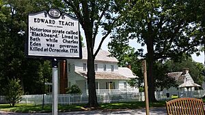
The pirate Blackbeard was very well-known in the southern colonies. He became famous for his piracy (stealing from ships) along the East Coast and in the West Indies. He lived in Bath for a short time in 1718. He even received a royal pardon, which was a special forgiveness offered by the king to try and stop piracy. But Blackbeard soon went back to his old ways. He was caught and killed later that same year by forces from Virginia.
During a religious movement called the Great Awakening, an English preacher named George Whitefield visited Bath four times between 1747 and 1762. He came to preach about his faith. On his last visit, the local church reportedly wouldn't let him preach. A writer named T. Jensen Lacy wrote that Whitefield eventually gave up on trying to change the people of Bath. He supposedly shook the dust from his shoes and declared that the town would remain small and forgotten because its people had not listened to his message.
Over time, other parts of North Carolina grew much faster than Bath. Major cities developed in the central part of the state, especially with the growth of railroads and factories in the 1800s. Bath has mostly stayed a quiet, small village on the coast. Even though the county's population has grown, Bath itself remains a peaceful historic spot.
Geography
Bath is a small town. Most of its area is water. According to the United States Census Bureau, the town covers about 2.4 square kilometers (0.9 square miles). About 0.9 square kilometers (0.36 square miles) is land, and 1.4 square kilometers (0.56 square miles) is water. This means over 60% of the town's area is water!
Population of Bath
| Historical population | |||
|---|---|---|---|
| Census | Pop. | %± | |
| 1880 | 89 | — | |
| 1900 | 400 | — | |
| 1910 | 283 | −29.2% | |
| 1920 | 274 | −3.2% | |
| 1930 | 361 | 31.8% | |
| 1940 | 380 | 5.3% | |
| 1950 | 381 | 0.3% | |
| 1960 | 346 | −9.2% | |
| 1970 | 231 | −33.2% | |
| 1980 | 207 | −10.4% | |
| 1990 | 154 | −25.6% | |
| 2000 | 275 | 78.6% | |
| 2010 | 249 | −9.5% | |
| 2020 | 245 | −1.6% | |
| U.S. Decennial Census | |||
In 2000, there were 275 people living in Bath. There were 122 households, and 86 families. The population density was about 759 people per square mile. Most of the people living in Bath were White (95.64%). There were also African American (2.91%) and Native American (1.09%) residents. About 1.82% of the population was Hispanic or Latino.
About 21.3% of households had children under 18 living with them. The average household had 2.25 people, and the average family had 2.73 people. The median age in the town was 49 years old. This means half the people were younger than 49 and half were older.
What to Do in Bath
Bath has not changed much since it was first settled. This makes it a popular place for "heritage tourism." People who like history come to visit from nearby areas and other states. During the summer, the town gets more visitors. Many people enjoy water activities like wakeboarding, water skiing, and boat rides on the creek and river.
Other fun things to see include:
- The Historic Bath State Historic Site: This site offers tours of the old town.
- St. Thomas Church: This is the oldest standing Episcopal Church in North Carolina.
- Historic houses: You can see many old homes.
- A visitors center: Here you can learn more about Bath's history.
- A ferry: This boat takes people from one side of the Pamlico River to the other.
- Goose Creek State Park: Visitors can explore beautiful marshes and swamps, rent canoes, and fish.
Besides these, the Bath School, Bonner House, and Palmer-Marsh House are also important historic places.
Learning and Libraries
The Bath Community Library is part of the BHM Regional Library system.
For school, students in Bath attend Beaufort County Schools. Younger students go to Bath Elementary School, which teaches grades K-8. Older students attend Northside High School.
|
See also
 In Spanish: Bath (Carolina del Norte) para niños
 | George Robert Carruthers |
 | Patricia Bath |
 | Jan Ernst Matzeliger |
 | Alexander Miles |


