
Arapahoe, North Carolina facts for kids
Quick facts for kids
Arapahoe, North Carolina
|
|
|---|---|
 |
|

Location of Arapahoe, North Carolina
|
|
| Country | United States |
| State | North Carolina |
| County | Pamlico |
| Founded | Circa 1714 |
| Incorporated | 1921 |
| Area | |
| • Total | 2.17 sq mi (5.62 km2) |
| • Land | 2.17 sq mi (5.62 km2) |
| • Water | 0.00 sq mi (0.00 km2) |
| Elevation | 43 ft (13 m) |
| Population
(2020)
|
|
| • Total | 416 |
| • Density | 191.62/sq mi (73.98/km2) |
| Time zone | UTC-5 (EST) |
| • Summer (DST) | UTC-4 (EDT) |
| ZIP Code |
28510
|
| Area code(s) | 252 |
| FIPS code | 37-01640 |
| GNIS feature ID | 2405159 |
Arapahoe (pronounced uh-RAP-uh-hoh) is a small town located in Pamlico County, North Carolina, in the United States. In 2020, about 416 people lived there. Arapahoe often works closely with the nearby town of Minnesott Beach, North Carolina. It is also part of the larger New Bern, North Carolina area.
Contents
The Story of Arapahoe
Arapahoe was founded around 1714 by settlers who moved from the New Bern, North Carolina colony. This area was first settled in 1703 along an old Native American trail. The community was originally known as "Bethany Crossroads." This old trail is still used today as North Carolina Highway 306.
In 1886, two friends, Bob Hardison and Bob Bowden, wanted to get a post office for their community. They applied, but their application came back addressed to "Bob's Town." This was because another "Bethany Crossroads" already existed near Fayetteville.
Neither Bob liked the name "Bob's Town." After thinking for a while, Bob Hardison suggested naming the town after his old white horse, Arapahoe. The name was chosen, and a new application was sent in. It took some time, but "Bethany Crossroads" officially became the Town of Arapahoe. The name "Arapahoe" comes from a Native American tribe whose lands were in what is now Wyoming and Colorado.
Learning and Education
Arapahoe offers great learning chances for kids from kindergarten all the way through high school.
Public Schools
Arapahoe Charter School opened in 1997. It replaced the old Arapahoe Elementary School. Today, about 560 students attend the school, and there are 40 teachers. This means there is about one teacher for every 14 students.
Arapahoe Charter School is now a K-12 school, meaning it teaches all grades from kindergarten to twelfth grade. It moved into a new building in 2018.
Arapahoe is also home to the Don Lee Center. This center was started by the Methodist church. It offers fun camping and recreation activities. It is also known for its environmental education programs.
College Opportunities
For students who want to continue their education after high school, Pamlico Community College (PCC) is nearby. PCC offers associate degrees in many different subjects. From PCC, students can transfer to East Carolina University to earn a bachelor's or even a graduate degree. PCC is just a few minutes away from Arapahoe on NC Highway 306.
Local Media
You can find out what's happening in Arapahoe and the surrounding area through local news sources.
- The Pamlico News: The Pamlico News
- Pamlico Ink: The Newspaper of the Pamlico Sound
Businesses in Arapahoe
Arapahoe has many small businesses. The biggest industry in town is farming. Other important businesses include seafood management, home improvement, and food services. There are also florists and other service industries. Making bio-diesel, which is a type of fuel, is also growing in the area.
Summer Camps
Another big part of Arapahoe's economy is its summer camps. There are four main camps in the area:
- Camp Sea Gull for boys (part of the YMCA)
- Camp Seafarer for girls (part of the YMCA)
- Camp Don Lee (Methodist)
- Camp Caroline
Most of these camps have their busiest programs during the summer. However, they also host events throughout the year. For example, Camp Seafarer and Camp Seagull offer special weekends for families.
Business Growth
There are many chances for new businesses to open in Arapahoe. For instance, there are not many hotels or entertainment places. There are also opportunities for more gas stations and convenience stores. When camp season happens, many families visit the area. If there were more hotels, it could bring a lot more money to Arapahoe.
Geography and Location
Arapahoe covers about 2.2 square miles (5.6 square kilometers) of land.
The town is located near where the Neuse River meets Pamlico Sound. From Arapahoe, you can take a 20-minute ferry ride. This ferry goes from Minnesott Beach to Cherry Branch. The ferry is part of the North Carolina Ferry System. This ferry ride connects Arapahoe to places like Havelock, Atlantic Beach, Cherry Point Marine Corps Air Station, and Beaufort.
Getting Around Town
Most people in Arapahoe get around by car. There are no taxi services, public buses, or airline services directly in Arapahoe.
The closest airport is Craven Regional Airport. From there, you can fly with American Airlines to Charlotte. Delta Connection also offers flights to Atlanta.
The North Carolina Ferry System provides ferry service from Minnesott Beach to Cherry Branch/Havelock. Ferries run every 20 minutes.

Population Information
| Historical population | |||
|---|---|---|---|
| Census | Pop. | %± | |
| 1930 | 290 | — | |
| 1940 | 307 | 5.9% | |
| 1950 | 273 | −11.1% | |
| 1960 | 274 | 0.4% | |
| 1970 | 212 | −22.6% | |
| 1980 | 467 | 120.3% | |
| 1990 | 430 | −7.9% | |
| 2000 | 436 | 1.4% | |
| 2010 | 556 | 27.5% | |
| 2020 | 416 | −25.2% | |
| U.S. Decennial Census | |||
In 2000, there were 436 people living in Arapahoe. These people lived in 188 homes, and 128 of these were families. The average household had about 2.32 people.
The population included people of different ages:
- About 20.6% were under 18 years old.
- About 6.9% were between 18 and 24.
- About 24.8% were between 25 and 44.
- About 31.0% were between 45 and 64.
- About 16.7% were 65 years old or older.
The average age of people in Arapahoe was 42 years old.
New Developments in Arapahoe
Arapahoe is seeing some new growth and projects.
- Community Living: New communities are being built along the Neuse River and Dawsons Creek. These are private areas designed for people to enjoy the river.
- New Homes:
- Shine Landing is a new housing community at Dawson's Creek. It has 96 lots, and many are on the waterfront. Most of these homes have already been sold.
- Dawsons Landing is another new housing community at Dawson's Creek. It has over 100 lots available for sale.
- Arlington Place is a large new community on Highway 306S. It plans to have up to 1200 homes, boat docks, and a community center. The first part of Arlington Place is almost completely sold out.
- Baird Creek Point is a new residential community on Baird Creek. It has about 40 home sites, including waterfront and inside lots. It also has a marina and a community center.
- Dawson Creek Subdivision is one of the largest developments. It has sold over 200 lots, with many waterfront homes being built. It has a pool, clubhouse, and plans for a private dock.
- Outdoor Fun: A water path has been created for people who enjoy kayaking and paddling. This path lets them explore the rivers and sounds of Pamlico County.
- Community Hub: The old Arapahoe Elementary School building is being turned into a medical and retail center.
- Local Services: A new gas station/convenience store and a hotel are being developed in nearby Minnesott Beach.
Images for kids
-
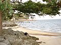
Neuse River in Arapahoe near Camp Don Lee

See also
 In Spanish: Arapahoe (Carolina del Norte) para niños
