Aurora, North Carolina facts for kids
Quick facts for kids
Aurora, North Carolina
|
|
|---|---|

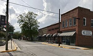
Main Street
|
|

Location of Aurora, North Carolina
|
|
| Country | United States |
| State | North Carolina |
| County | Beaufort |
| Area | |
| • Total | 1.03 sq mi (2.66 km2) |
| • Land | 0.93 sq mi (2.40 km2) |
| • Water | 0.10 sq mi (0.26 km2) |
| Elevation | 10 ft (3 m) |
| Population
(2020)
|
|
| • Total | 455 |
| • Density | 490.30/sq mi (189.27/km2) |
| Time zone | UTC-5 (Eastern (EST)) |
| • Summer (DST) | UTC-4 (EDT) |
| ZIP code |
27806
|
| Area code(s) | 252 |
| FIPS code | 37-02620 |
| GNIS feature ID | 2405186 |
Aurora is a small town in Beaufort County, North Carolina, in the United States. In 2020, about 455 people lived there.
Geography
Aurora is located in North Carolina. It covers a total area of about 2.7 square kilometers (1.03 square miles). Most of this area is land, with a small part being water.
Just outside the town, you'll find the large Aurora phosphate mine. This mine is important for the area.
Climate
Aurora has a mild climate. The weather box below shows the average temperatures and rainfall for the town.
| Climate data for AURORA 6 N, NC, 1991-2020 normals | |||||||||||||
|---|---|---|---|---|---|---|---|---|---|---|---|---|---|
| Month | Jan | Feb | Mar | Apr | May | Jun | Jul | Aug | Sep | Oct | Nov | Dec | Year |
| Mean daily maximum °F (°C) | 53.4 (11.9) |
55.6 (13.1) |
62.2 (16.8) |
71.8 (22.1) |
78.5 (25.8) |
85.6 (29.8) |
88.9 (31.6) |
87.0 (30.6) |
81.9 (27.7) |
73.4 (23.0) |
63.8 (17.7) |
56.3 (13.5) |
71.5 (21.9) |
| Daily mean °F (°C) | 44.8 (7.1) |
47.0 (8.3) |
53.2 (11.8) |
62.2 (16.8) |
70.2 (21.2) |
77.7 (25.4) |
81.3 (27.4) |
79.8 (26.6) |
74.9 (23.8) |
65.2 (18.4) |
55.6 (13.1) |
48.0 (8.9) |
63.3 (17.4) |
| Mean daily minimum °F (°C) | 36.2 (2.3) |
38.3 (3.5) |
44.2 (6.8) |
52.7 (11.5) |
61.9 (16.6) |
69.9 (21.1) |
73.8 (23.2) |
72.7 (22.6) |
68.0 (20.0) |
57.0 (13.9) |
47.5 (8.6) |
39.8 (4.3) |
55.2 (12.9) |
| Average precipitation inches (mm) | 3.90 (99) |
3.41 (87) |
3.75 (95) |
3.54 (90) |
3.97 (101) |
5.12 (130) |
5.24 (133) |
5.92 (150) |
5.90 (150) |
4.01 (102) |
3.12 (79) |
3.68 (93) |
51.56 (1,310) |
| Average snowfall inches (cm) | 0.1 (0.25) |
0.1 (0.25) |
0.0 (0.0) |
0.0 (0.0) |
0.0 (0.0) |
0.0 (0.0) |
0.0 (0.0) |
0.0 (0.0) |
0.0 (0.0) |
0.0 (0.0) |
0.0 (0.0) |
0.0 (0.0) |
0.2 (0.51) |
| Average precipitation days (≥ 0.01 in) | 10.6 | 9.6 | 10.0 | 8.4 | 9.4 | 9.7 | 12.1 | 10.4 | 9.0 | 7.8 | 8.2 | 10.0 | 115.2 |
| Source: NOAA | |||||||||||||
Demographics
| Historical population | |||
|---|---|---|---|
| Census | Pop. | %± | |
| 1880 | 81 | — | |
| 1890 | 251 | 209.9% | |
| 1900 | 314 | 25.1% | |
| 1910 | 440 | 40.1% | |
| 1920 | 524 | 19.1% | |
| 1930 | 429 | −18.1% | |
| 1940 | 492 | 14.7% | |
| 1950 | 525 | 6.7% | |
| 1960 | 449 | −14.5% | |
| 1970 | 620 | 38.1% | |
| 1980 | 698 | 12.6% | |
| 1990 | 654 | −6.3% | |
| 2000 | 583 | −10.9% | |
| 2010 | 520 | −10.8% | |
| 2020 | 455 | −12.5% | |
| U.S. Decennial Census | |||
The population of Aurora has changed over the years. In 1880, only 81 people lived there. The population grew to 698 people in 1980, but has since decreased to 455 people in 2020.
In 2000, there were 583 people living in Aurora. About half of the people were White, and nearly half were African American. A small number of people were from other backgrounds.
The average age of people in Aurora in 2000 was 43 years old. About 23% of the population was under 18 years old.
Media
- The Pamlico News: This is a newspaper that covers news for the area around Pamlico Sound.
- 104.5 FM WSTK Surge Radio: This is a radio station that plays popular music.
Museum

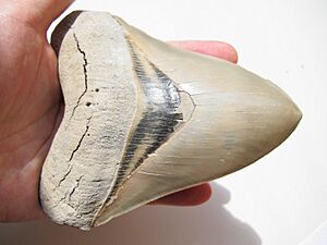
Aurora is home to the Aurora Fossil Museum. This museum has many cool fossils found in the local PCS Phosphate Mine. You can see fossils of ancient sea creatures from millions of years ago.
The museum also has a display of gems and minerals. There's even a special room where you can see fossils and minerals glow under a black light! Plus, there's a room filled with old Native American tools and items, and a new "Mine Room" to explore.
Education
Students in Aurora attend schools run by Beaufort County Schools.
- S. W. Snowden School: This school teaches students from kindergarten through 8th grade.
- Southside High School: This is the high school for older students.
The Hazel W. Guilford Memorial Library in Aurora is part of the BHM Regional Library system.
Notable people
- Richard Coffey: He was a professional basketball player in the NBA.
See also
 In Spanish: Aurora (Carolina del Norte) para niños
 | Claudette Colvin |
 | Myrlie Evers-Williams |
 | Alberta Odell Jones |

