Bethel, North Carolina facts for kids
Quick facts for kids
Bethel, North Carolina
|
|
|---|---|

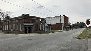
Town hall
|
|

Location of Bethel, North Carolina
|
|
| Country | United States |
| State | North Carolina |
| County | Pitt |
| Area | |
| • Total | 1.05 sq mi (2.73 km2) |
| • Land | 1.05 sq mi (2.73 km2) |
| • Water | 0.00 sq mi (0.00 km2) |
| Elevation | 69 ft (21 m) |
| Population
(2020)
|
|
| • Total | 1,373 |
| • Density | 1,305.13/sq mi (503.74/km2) |
| Time zone | UTC-5 (Eastern (EST)) |
| • Summer (DST) | UTC-4 (EDT) |
| ZIP code |
27812
|
| Area code(s) | 252 |
| FIPS code | 37-05460 |
| GNIS feature ID | 2405253 |
| Website | http://www.bethelnc.org/ |
Bethel is a small town in Pitt County, North Carolina, United States. It is part of the Greenville Metropolitan Area. This area is known as North Carolina's Inner Banks region.
In 2020, about 1,373 people lived in Bethel. It's interesting to know that there are other places named Bethel in North Carolina. This town is just one of them!
Contents
History of Bethel
The area where Bethel is located was settled a long time ago. This was even before the American Civil War. The town of Bethel officially became a town in 1873. It got its name from the Bethel Methodist Church.
Getting Around Bethel
Several main roads help people travel through Bethel. These include US 64, US 13, and NC 11.
- US 64 connects Bethel to Raleigh. Raleigh is the capital city of North Carolina.
- US 13 links Bethel to nearby cities like Greenville and Fayetteville. It also connects to cities in eastern Virginia.
- NC 11 provides a route to Greenville and Kinston.
The town of Bethel covers a total area of about 2.73 square kilometers (1.05 square miles). All of this area is land.
People of Bethel
The town of Bethel has a diverse population. In 2020, there were 1,373 people living here. These people lived in 754 households.
Who Lives in Bethel?
| Group | Number of People | Percentage |
|---|---|---|
| White (not Hispanic) | 496 | 36.13% |
| Black or African American (not Hispanic) | 752 | 54.77% |
| Native American | 10 | 0.73% |
| Asian | 1 | 0.07% |
| Pacific Islander | 2 | 0.15% |
| Other/Mixed Race | 38 | 2.77% |
| Hispanic or Latino | 74 | 5.39% |
Schools in Bethel
Students in Bethel attend local schools. The main schools are:
- North Pitt High School
- Bethel Elementary School
Famous People from Bethel
- Almyra Maynard Watson (1917–2018): She was an officer in the United States Army Nurse Corps. She served her country as a nurse.
See also
 In Spanish: Bethel (Carolina del Norte) para niños
 | Aurelia Browder |
 | Nannie Helen Burroughs |
 | Michelle Alexander |


