
Hawaii (island) facts for kids
|
Nickname: The Big Island, Moku o Keawe
|
|
|---|---|

Landsat mosaic, 1999–2001
|
|
.svg)
Location in the state of Hawaii
|
|
| Geography | |
| Location | North Pacific Ocean |
| Coordinates | 19°36′N 155°30′W / 19.6°N 155.5°W |
| Area | 4,028 sq mi (10,430 km2) |
| Area rank | Largest Hawaiian Island |
| Highest elevation | 13,803 ft (4,207.2 m) |
| Highest point | Mauna Kea |
| Administration | |
|
United States
|
|
| Symbols | |
| Flower | Red Pua Lehua (ʻOhiʻa blossom) |
| Color | ʻUlaʻula (red) |
| Largest settlement | Hilo |
| Demographics | |
| Population | 200,629 (2020) |
| Pop. density | 49.8 /sq mi (19.23 /km2) |
| Additional information | |
| Time zone | |
Hawaii (pronounced "huh-WY-ee") is the largest island in the United States. It is part of the state of Hawaii. This island is the most southeastern of the Hawaiian Islands. These islands are a chain of volcanic islands in the North Pacific Ocean.
Hawaii Island covers about 4,028 square miles (10,432 square kilometers). This means it makes up 63% of all the land in the Hawaiian islands. But only 13% of the people in Hawaii live here. The island of Hawaiʻi is also the third largest island in Polynesia. Only the North and South islands of New Zealand are bigger.
People often call it the Island of Hawaii or Hawaii Island. This helps tell it apart from the entire state of Hawaii. It is also known as The Big Island because it is so much larger than the other islands. In the Hawaiian language, the island is sometimes called Moku o Keawe. This name comes from an ancient chief or means "the bearer." Hawaii County is the local government for the island.
In 2020, about 200,629 people lived on the island. The biggest town and main government center is Hilo. Hawaii County does not have any official cities.
Contents
Discovering Hawaii's Past

Many people believe Hawaii Island is named after Hawaiʻiloa. He was a legendary Polynesian navigator who might have found the island. Other stories say the name comes from Hawaiki. This is a mythical place where some Polynesians believe they came from. It is also thought to be a place for the afterlife or for gods.
James Cook, an English explorer, was the first European to reach the Hawaiian Islands. He called this island O-Why-hee. He also named the whole group of islands the "Sandwich Islands." This was to honor his supporter, the Earl of Sandwich.
Hawaii Island was the home of Paiʻea Kamehameha. He later became known as Kamehameha the Great. In 1795, after many years of fighting, Kamehameha united most of the Hawaiian islands. He named the new kingdom and the island chain after his home island. In 1822, a missionary named William Ellis visited. He wrote about his travels around the island in his journal.
Exploring Hawaii's Land and Nature

Hawaii County covers about 5,086 square miles (13,170 square kilometers). About 4,028 square miles (10,432 square kilometers) is land. The rest, about 1,058 square miles (2,740 square kilometers), is water. The land area of Hawaii County is 62.7% of the entire state's land. This is the highest percentage for any county in the United States.
The island is about 93 miles (150 kilometers) wide at its longest point. Mauna Kea is the world's tallest mountain when measured from its base on the ocean floor. It stands about 10,000 meters (32,808 feet) tall. This makes it taller than Mount Everest, which starts above sea level.
Ka Lae is the southernmost point in all 50 states of the United States. It is located on Hawaii Island. The closest land to the south is the Line Islands. To the northwest of Hawaii Island is Maui. You can see Maui's Haleakalā volcano from Hawaii across the Alenuihaha Channel.

Volcanoes Shaping the Island


Hawaii Island was formed by five different shield volcanoes. They erupted one after another, with each new volcano overlapping the older ones. These volcanoes are:
- Kohala – This volcano is now extinct, meaning it will not erupt again.
- Mauna Kea – This volcano is dormant, meaning it is currently quiet but could erupt in the future.
- Hualālai – This volcano is active, meaning it can erupt.
- Mauna Loa – This volcano is active, and part of it is inside Hawaiʻi Volcanoes National Park.
- Kīlauea – This volcano is also active and is part of Hawaiʻi Volcanoes National Park.
Because Mauna Loa and Kīlauea are active, the island is still growing! Between 1983 and 2002, lava flows added about 543 acres (220 hectares) to the island. Lava from Kīlauea has destroyed towns like Kapoho (in 1960 and 2018) and Kalapana (in 1990). In 2018, another 875 acres were added by new lava flows. Mauna Loa erupted in 2022, which was 38 years after its last eruption.
Some scientists also count two undersea volcanoes as part of the island's base. Māhukona is off the northwest corner and is now below the ocean surface. Kamaʻehuakanaloa (once called Lōʻihi) is underwater southeast of Hawaii. It is an erupting seamount that has grown to be 3,200 feet (975 meters) below the ocean surface. Scientists believe it will reach the surface in 10,000 to 100,000 years.
The Great Crack

The Great Crack is a large crack in the island. It is about 8 miles (13 kilometers) long, 60 feet (18 meters) wide, and 60 feet (18 meters) deep. It is located in the Ka'u district. Scientists believe the Great Crack formed because magma pushed up from below. Lava flowed out of the lower part of the crack in 1823.
Old trails, rock walls, and ancient sites from the 12th century are found near the Great Crack. In 2018, the National Park Service bought land next to Hawaiʻi Volcanoes National Park. They wanted to protect this area because of its important geological features.
The Hilina Slump

_Hawaii_Christmas.jpg)
The Hilina Slump is a large section of Kīlauea's south slope. It is slowly moving away from the island. Between 1990 and 1993, measurements showed it moved about 10 centimeters (4 inches) south each year. Underwater studies show a "bench" that acts like a support. This support might help prevent the slump from breaking off completely.
Earthquakes and Tsunamis

On April 2, 1868, a very strong earthquake hit Hawaii's southeast coast. It was one of the most damaging earthquakes in Hawaii's history. It caused a landslide on Mauna Loa, killing 31 people. A tsunami (a giant ocean wave) followed, taking 46 more lives. Villages like Punaluʻu and Honuʻapo were badly damaged. The tsunami was so powerful it reportedly rolled over coconut trees, reaching up to 60 feet (18 meters) high. It also went inland about a quarter of a mile (400 meters) in some places.
On November 29, 1975, a part of the Hilina Slump moved. This caused a 7.2 magnitude earthquake and a 48-foot (15-meter) high tsunami. Two people died, and 19 were hurt.
Hawaii Island also suffered damage from tsunamis caused by earthquakes far away. These included one in Alaska in 1946 and one in Chile in 1960. Downtown Hilo was damaged by both. In 1946, 16 schoolchildren and five teachers were lost in the tsunami at Laupāhoehoe.
In March 2011, a huge earthquake off Japan caused another tsunami. It caused minor damage in Hawaii. In the Kona area, a house was washed into a bay, and a yacht club was destroyed.
In May 2018, hundreds of small earthquakes were felt near Kīlauea. This led to warnings and evacuations. On May 3, 2018, the volcano erupted in Puna after a 5.0 magnitude earthquake. A day later, a 6.9 magnitude earthquake also occurred.
Volcanic Fog (Vog)
.jpg)
When Kilauea is active, Vog (volcanic fog) can cover Hawaii Island. Vog is a mix of volcanic gases and tiny particles. It can harm plants, people, and animals. The tiny acidic particles can get into lungs and cause flu-like symptoms. People with breathing problems are especially affected. Since the volcanic activity stopped in September 2018, vog has mostly disappeared from the west side of the island.
Protected Natural Areas

Hawaii Island has many unique natural areas. Some of these are protected by the government:
- Ala Kahakai National Historic Trail
- Hakalau Forest National Wildlife Refuge
- Hawaiʻi Volcanoes National Park
- Kaloko-Honokōhau National Historical Park
- Kohala Historical Sites State Monument (Mookini Heiau)
- Kona Forest National Wildlife Refuge
- Puʻuhonua o Hōnaunau National Historical Park
- Puʻukoholā Heiau National Historic Site


Hawaii's Economy and Jobs
For over a century, Sugarcane was the main part of the island's economy. But in the mid-1900s, sugarcane farms started to shrink. The last one on the island closed in 1995.
Today, most of the island's economy relies on tourism. Many resorts are found on the western coast, in the North Kona and South Kohala areas. There is also a growing focus on sustainable tourism, which aims to protect the environment.
Farming different crops is also growing. Important crops include macadamia nuts, papaya, flowers, and coffee beans. The island also grows the most orchids in the state. Hawaii Island is home to one of the largest cattle ranches in the United States, Parker Ranch. It covers about 175,000 acres (708 square kilometers) in Waimea.
The island is famous for astronomy. Many telescopes are located on top of Mauna Kea at the Mauna Kea Observatories. The air there is very clear, and there is little light pollution. Astronomy has become a bit controversial. This is due to concerns about how the observatories are managed.
The NELHA is a special site on the west side of the island. It is 675 acres (273 hectares) big. NELHA focuses on green economic development, ocean science, and technology. It provides resources for research, education, and businesses that use ocean energy. Businesses there include farms for tiny algae, aquaculture (fish farming), and solar technology companies. These businesses can use deep-sea water from up to 3,000 feet (914 meters) below the surface. They also have access to clean surface water and almost constant sunshine. In 2012, a study showed that NELHA's activities brought in $87.7 million and created 583 jobs.
Getting Around Hawaii Island

Roads for Travel
Three main roads connect the two biggest towns: Hilo on the east coast and Kailua-Kona on the west coast.
- State highways 19 & 190: This is the northern route through Waimea.
- State highway 11: This is the southern route, passing through Hawaiʻi Volcanoes National Park.
- Saddle Road (also called the Daniel K. Inouye Memorial Highway): This road goes between Mauna Loa and Mauna Kea.
Other important roads include State highways 270 (from Kawaihae to Hawi) and 180 (the "Kona coffee road"). You can rent cars at the international airports. Taxi service is also available. The Hele-On Bus provides bus service across the entire island.
Airports for Flights
Two commercial airports serve Hawaii Island:
- Hilo International Airport (ITO)
- Kona International Airport (KOA)
There are also two private airports:
- Waimea-Kohala Airport (MUE)
- Upolu Airport (UPP)
Seaports for Ships
The main commercial ports are Hilo on the east side and Kawaihae on the west side. Cruise ships often visit Kailua-Kona and Hilo.

Fun Places to Visit


Hawaii Island has many interesting places to explore:
- Akaka Falls, one of the island's tallest waterfalls.
- Amy B. H. Greenwell Ethnobotanical Garden has many rare native plants.
- East Hawaiʻi Cultural Center
- Hawaiʻi Tropical Botanical Garden
- Hawaiʻi Volcanoes National Park, home to the active volcanoes Kīlauea and Mauna Loa.
- Huliheʻe Palace, a former royal palace in Kailua-Kona.
- ʻImiloa Astronomy Center in Hilo.
- Ka Lae, the southernmost point in the United States.
- Laupāhoehoe Train Museum.
- Lyman House Memorial Museum in Hilo.
- Manuka State Wayside Park
- Mauna Kea Observatories
- Nani Mau Gardens
- Onizuka Center for International Astronomy
- Pacific Tsunami Museum overlooking Hilo Bay.
- Pana'ewa Rainforest Zoo in Hilo.
- Pua Mau Place Arboretum and Botanical Garden
- Puʻuhonua o Hōnaunau National Historical Park
- Puʻukoho'ā Heiau National Historic Site, a very important ancient Hawaiian temple.
- Rainbow Falls State Park
- Sadie Seymour Botanical Gardens
- Umauma Falls
- University of Hawaiʻi at Hilo Botanical Gardens
- Waipiʻo Valley
- Wao Kele o Puna
- World Botanical Gardens
Maps
-
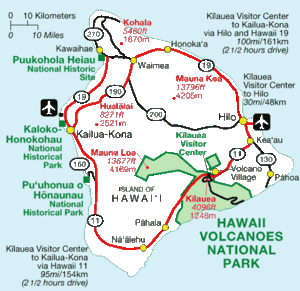
National parks, mountains and cities on the island.
-
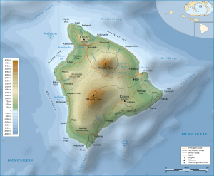
A map showing the shape of the land on Hawaii Island.
-
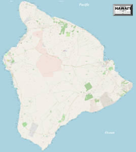
A detailed map of Hawaii Island.


- Interactive 3D model for Chrome or Firefox
See also
 In Spanish: Isla de Hawái para niños
