Hilina Slump facts for kids
The Hilina Slump is a very large piece of land on the side of Kīlauea Volcano in Hawaiʻi. It's one of many huge landslides that happen around the Hawaiian Islands. These landslides help move rock and dirt from the volcanoes down to the seabed, making the islands bigger over time.
The entire southern side of Kīlauea Volcano is slowly sliding towards the sea. Some parts of the Hilina Slump move about 10 centimeters (4 inches) every year! This happens because new magma (hot, melted rock) pushes from inside the volcano, and gravity pulls the land downhill.
You might have heard scary stories about a "megatsunami" if the Hilina Slump suddenly broke off. But don't worry! Scientists who study the Earth (geologists) are quite sure this won't happen. Other experts also say that these big tsunami threats are much bigger in stories than they are in real life.
Contents
How Hawaii's Islands Form
The Hawaiian Islands are all volcanoes. They are part of a long chain of underwater mountains and islands called the Hawaiian–Emperor seamount chain. These islands form because of a special spot deep in the Earth called the Hawaii hotspot. This hotspot melts rock, creating magma that rises and erupts, building volcanoes.
The Pacific Plate (a giant piece of the Earth's crust) slowly moves northwest. As it moves, it carries older volcanoes away from the hotspot. New volcanoes then form at the southeastern end of the chain. The newest and biggest island is the Big Island of Hawaiʻi. It was made when seven volcanoes grew together. Mauna Loa is the largest volcano on the island, and Kīlauea is a younger volcano on its side. There's even a new underwater volcano, Lōʻihi Seamount, growing nearby!
Hawaiian volcanoes are called shield volcanoes. They look like a warrior's shield lying on the ground. This means they are very wide with gentle slopes, unlike the cone-shaped volcanoes you might see in pictures. For example, Kīlauea's slope is only about 6 degrees from its top to the ocean floor. When a volcano is over the hotspot, it gets lots of magma and grows very wide. When it moves away, it stops erupting and slowly wears away.
Kīlauea is made of many layers of hardened lava flows. These layers have cracks and weaker spots. The heavy weight of the volcano causes the land to stretch and slide downhill. This creates cracks and faults (breaks in the Earth's crust) that run parallel to the coast. These breaks can cause large blocks of land to slip.
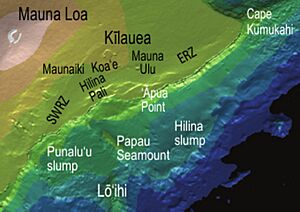
On Kīlauea's side facing the ocean, magma often flows out of the main crater and moves along long cracks called rift zones. These are the Southwest Rift Zone (SWRZ) and East Rift Zone (ERZ). They run parallel to the coast. You can also see the Hilina Pali cliffs. These cliffs are like the top edge of a giant landslide where a big block of land has moved down and out.
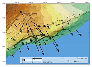
The rift zones help lava travel many kilometers away from the volcano's center, like during the 2018 lower Puna eruption. They also act like wedges, pushing the south side of Kīlauea downhill. This sliding happens on a nearly flat fault line deep underground (about 8 to 10 kilometers deep) called a décollement. Because of this pushing and sliding, the entire south side of Kīlauea is slowly moving towards the sea, especially around the Hilina Pali. It moves up to 10 centimeters (about 4 inches) each year!
What is the Hilina Slump?
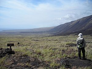
The Hilina Pali cliffs are very tall, about 300 meters (1,000 feet) high. Scientists realized as early as 1930 that these cliffs were formed by the coast slumping. The Hilina Pali is the top edge of the Hilina Slump. A slump is a type of landslide where a big piece of land slides along a curved surface. The top part drops down, and the bottom part often pushes up and out.
The Hilina Slump stretches out from the Hilina Pali towards the ocean, reaching depths of 5,000 meters (16,400 feet). Scientists are still debating if this slump is shallow or if it reaches all the way down to the deep fault line (décollement) that is under the whole south side of Kīlauea.
In the late 1980s, scientists found that the entire south side of Kīlauea is part of huge underwater landslides. So, sometimes the term "Hilina Slump" is used to describe this wider area.
The Hilina Slump is sliding seaward on top of Kīlauea at an average speed of 10 centimeters (4 inches) per year. Kīlauea makes up about 13.7% of the Big Island of Hawaii. The Hilina Slump itself is huge, about 10,000 to 12,000 cubic kilometers in size. That's about 10% of the entire island!
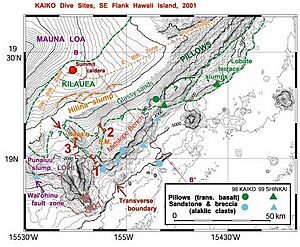
Recent studies show that an underwater "bench" has formed in front of the Hilina Slump. This bench acts like a support, making it less likely for the slump to suddenly break off. This is good news!
Big Earthquakes in Hawaii
Earthquakes in Hawaiʻi happen for two main reasons. Either magma is moving deep inside the volcanoes, or the huge landmasses of the islands are sliding. Sometimes the land slides slowly without big earthquakes. Other times, it moves suddenly, causing a large earthquake (magnitude 6 or higher).
The 1868 Earthquake
On April 2, 1868, a very strong earthquake hit the southeast coast of Hawaiʻi. It was estimated to be between magnitude 7.25 and 7.75. This earthquake caused a landslide on Mauna Loa volcano, killing 31 people. A tsunami (a giant ocean wave) followed, taking 46 more lives. Many villages like Punaluʻu and Nīnole were badly damaged. One person said the tsunami "rolled in over the tops of the coconut trees, probably 60 feet (20 m) high." It went far inland, pulling houses and people back out to sea.
The 1975 Earthquake
| UTC time | 1975-11-29 14:47:40 |
|---|---|
| ISC event | 722344 |
| USGS-ANSS | ComCat |
| Local date | November 29, 1975 |
| Magnitude | Mw 7.7 |
| Depth | 9 km |
| Epicenter | 19°19′59″N 155°00′07″W / 19.333°N 155.002°W |
A similar earthquake happened on November 29, 1975, with a magnitude of 7.2. A 60-kilometer (40-mile) wide part of the Hilina Slump slid 3 meters (11 feet) into the ocean! This movement also caused a tsunami. The tsunami reached a height of 14 meters (47 feet) at Keauhou Landing. Houses near the ocean were washed away in Punaluʻu. Sadly, two people died, and 19 others were hurt. The coastline at Keauhou Bay changed a lot after this event.
The 2018 Earthquake
| UTC time | 2018-05-04 22:32:55 |
|---|---|
| ISC event | 611928827 |
| USGS-ANSS | ComCat |
| Local date | May 4, 2018 |
| Local time | 12:33 p.m. HST |
| Magnitude | 6.9 Mww |
| Depth | 2.1 km |
| Epicenter | 19°18′47″N 154°59′53″W / 19.313°N 154.998°W |
On May 4, 2018, a magnitude 6.9 earthquake happened. This caused the Hilina Slump to move about 60 centimeters (two feet). This earthquake likely happened because of the magma moving during the 2018 lower Puna eruption in Kīlauea's eastern rift zone. In turn, the earthquake then led to even more volcanic activity. This shows how earthquakes and eruptions can be connected, just like in 1868 and 1975.
Understanding Landslides
Young shield volcanoes like Kīlauea have wide, gentle slopes. But older Hawaiian islands have steep cliffs (called pali), deep valleys, and narrow ridges. For a long time, scientists wondered how these older islands got their rugged look. In 1930, it was suggested that huge landslides might be the cause.
Later, in 1964, scientists noticed that some areas of the seafloor had very bumpy ground below what looked like giant bowl-shaped areas on the islands. This hinted at the possibility of gigantic landslides. But it wasn't until the late 1980s, when scientists mapped the seafloor more carefully, that they found 17 areas around the islands that were clearly remnants of huge landslides.
Some of these landslides were truly enormous! They involved massive amounts of rock (like 5,000 cubic kilometers for one slide called Nuuanu). Huge blocks of rock, tens of kilometers in size, were carried 50 kilometers (30 miles) or more. This rapid movement suggests that some of these slides were indeed gigantic. They could have created giant tsunamis.
One of these areas is the south side of Kīlauea, which includes the Hilina Slump. Since it's still moving, some people worry that if Kīlauea's south side failed suddenly, it could create a tsunami that might threaten cities across the Pacific Ocean. They even suggest that a small movement of the Hilina Slump could be "truly disastrous" for Hawaii and possibly other places around the Pacific.
However, experts say that while Hawaiʻi faces a real threat from smaller, local events, the danger to far-off places across the Pacific is "exaggerated." The biggest, most dramatic landslides seen around Hawaii are called debris avalanches. In these, the rock breaks into small pieces and flows like a fast, narrow river. These can cause giant tsunamis because they happen very suddenly.
On the other hand, slumps (like the Hilina Slump) are different. They are mostly intact blocks of land that are wider and thicker than debris avalanches. They usually move slowly. Slumps typically slide on a curved surface, with the top dropping down (like at the Hilina Pali) and the bottom pushing up.
The movement of Kīlauea's side has mostly stopped on its western end because of underwater mountains called Lōʻihi and Papaʻu seamounts. It's also slowed down east of the Hilina Slump by the Hohonu Seamount. Plus, that "Midslope Bench" we talked about earlier helps support the Hilina Slump. Because of these natural supports, scientists believe a sudden, huge break-off of the Hilina Slump is very unlikely. So, those "dire predictions" you might hear are probably "overstated."
What About Megatsunamis?
You might wonder if a volcano's side collapsing in Hawaii could cause "towering waves" that crash onto the coasts of North America and Asia.
People became more aware of "megatsunamis" in 2001. That's when a scientific journal published an article by Steven Ward and Simon Day. They claimed that the Cumbre Vieja volcano in the Canary Islands might have a huge part of its side (about 500 cubic kilometers of rock) fall into the ocean. They said this could cause waves as high as 100 meters (330 feet) on the African coast and 25-meter (80-foot) waves in Florida! Even though they didn't say when this would happen, some people thought it could be "any time now."
Since we know the Hawaiian islands are surrounded by areas where huge parts of volcanoes have slid into the sea (the Hilina Slump alone is estimated at 10,000–12,000 cubic kilometers!), it seems fair to think about the risk of volcanic activity in Hawaiʻi causing problems around the Pacific.
However, a report by the U.S. Geological Survey for the U.S. Nuclear Regulatory Commission says the threat of megatsunamis is "exaggerated." What many news reports missed was that the 25-meter waves hitting Florida were only in the worst-case scenario. With "more modest assumptions," the waves were calculated to be only 3 to 8 meters high. Around the same time, another study in Switzerland looked at the same worst-case scenario and predicted that the biggest wave off the U.S. east coast would be less than one meter!
Another study by Pararas-Carayannis in 2002 found problems with Ward and Day's calculations. He said they made unrealistic assumptions about how big the slide would be, how fast it would happen, and how it would create a tsunami. He also pointed out that:
Volcano collapses and large landslides from eruptions like Krakatau in 1883 and Santorin in 1490 B.C., caused huge local tsunamis, but no big waves in faraway places.
Pararas-Carayannis concluded that neither geology nor past events show that Kīlauea's southern side is "unusually unstable" or that a massive collapse is likely soon. Even if such a collapse happened, he said the effects of the tsunami in faraway places "have been greatly overstated."
 | Jessica Watkins |
 | Robert Henry Lawrence Jr. |
 | Mae Jemison |
 | Sian Proctor |
 | Guion Bluford |


