
Cumbre Vieja facts for kids
Quick facts for kids Cumbre Vieja |
|
|---|---|
_La_Palma_%26_La_Gomera_Islands,_Canary_Islands_(cropped).jpg)
Satellite photo of La Palma island in 2016, with Cumbre Vieja on the southern part of the island (picture is oriented with north at the top)
|
|
| Highest point | |
| Elevation | 1,949 m (6,394 ft) |
| Geography | |
| Location | La Palma, Canary Islands, Spain |
| Geology | |
| Mountain type | Stratovolcano |
| Last eruption | 2021 |
The Cumbre Vieja (which means "Old Summit") is an active volcano on La Palma island in the Canary Islands, Spain. It is a long ridge of volcanoes that runs from north to south, covering the southern half of La Palma. This ridge has many craters and cones.
The most recent eruption of Cumbre Vieja started on September 19, 2021. It happened in a forest area called Cabeza de Vaca. Hot lava quickly flowed down the slopes, covering towns and banana plantations. It destroyed thousands of buildings. The lava also poured into the ocean, making the island bigger in some places. The volcano became quiet on December 13, 2021. On December 25, 2021, the local government announced the eruption was over.
Cumbre Vieja also erupted twice in the 20th century. These eruptions happened in 1949 and 1971.
Contents
Volcanic History of Cumbre Vieja

La Palma is a volcanic island in the ocean. It sits on the African Plate. La Palma is one of the most active volcanoes in the Canary Islands, along with Tenerife. For about 125,000 years, all eruptions on La Palma have come from the Cumbre Vieja. This volcanic ridge is about 25 kilometers (15 miles) long.
Scientists have studied the volcano's structure. They found that the way magma moves inside the volcano has changed over time. It used to have three main paths for magma, but now it mostly has one path that runs north to south. This change might be because of how the volcano's sides are moving.
Historical eruptions on Cumbre Vieja happened in:
- 1470
- 1585
- 1646
- 1677
- 1712
- 1949
- 1971
- 2021
The 1949 Eruption

The 1949 eruption began on June 24. This day is a special holiday for St. John, so the eruption is sometimes called "The Eruption of St. John's volcano." During this eruption, lava and gases came out from three main spots: Duraznero, Llano del Banco, and Hoyo Negro.
Mild explosive activity happened at the Duraznero vent. Lava flowed from the Llano del Banco vents. At the Hoyo Negro vent, there were only mild bursts of steam and ash. On July 30, the last day of the eruption, lava also came out from the Duraznero vent.
During the eruption, on July 1 and 2, two strong earthquakes occurred. They were very powerful, shaking the ground a lot. After these earthquakes, a long crack appeared in the ground. It was about 2.5 kilometers (1.6 miles) long. Parts of the western side of the Cumbre Vieja ridge moved about 1 meter (3 feet) sideways and 2 meters (6.5 feet) downwards. Near the Duraznero and Hoyo Negro vents, the ground moved down about 4 meters (13 feet). This crack is still visible today.

The first signs of the eruption were small earthquakes. These were felt on July 23, 1936, and continued for a few days. Over the next years, more earthquakes happened from time to time. However, there was no special equipment to measure them.
On June 24, 1949, the Duraznero vent opened. It released gases and rocks. This activity continued until July 6. The strong earthquakes on July 1 and 2 caused the long crack to appear. This crack is still a topic of discussion among scientists.
Eruptive activity at Duraznero stopped on July 6. On July 8, new activity started at the Llano del Banco vents, about 4 kilometers (2.5 miles) north of Duraznero. Lava flowed down the western side of the volcano. On July 10, this lava reached the coast at Puerto de Naos and flowed into the Atlantic Ocean. It formed new land, moving very fast.
On July 12, mild explosive activity began at Hoyo Negro. This showed that the eruption had reached underground water. Activity at Hoyo Negro stopped on July 22, and at Llano del Banco on July 26. Then, on July 30, the Duraznero vent became active again. Lava flowed from it, filling a nearby crater and forming a lava lake. This lake overflowed, and lava flowed down the eastern side towards the ocean. It stopped about 30 meters (100 feet) from the sea. All eruption activity ended on July 30. Scientists estimate that about 60 million cubic meters of lava erupted.
How Strong Was the 1949 Eruption?
The 1949 eruption was mostly a strombolian type. This means it had mild explosions and lava flows. Scientists use a scale called the Volcanic Explosivity Index (VEI) to measure eruptions. The 1949 eruption was given a VEI of 2. This is a relatively small to medium eruption.
Earthquakes During the Eruption
.jpg)
The earthquakes on July 1 and 2, 1949, were likely caused by rising magma. This magma heated water trapped inside the volcano. The water was under great pressure, so it couldn't turn into steam. Instead, it expanded and pushed against the side of the volcano. This caused the ground to shake and the large crack to form.
Scientists know the water didn't turn into steam because there were no big steam explosions. Only at the Hoyo Negro vent was there some mild activity involving water. Unlike the northern part of La Palma, the Cumbre Vieja area is quite dry. There are no large underground water tunnels there. This supports the idea that the earthquakes were caused by superheated water pushing on the volcano's flank.
Because there was no special equipment to measure earthquakes back then, what we know about them comes from people who felt them.
The 1971 Eruption
The 1971 eruption happened at the southern end of Cumbre Vieja, at a vent called Teneguía. This eruption was also mainly strombolian, with lava flows. Earthquakes happened before and during this eruption, but they were not as strong as those in 1949. Some heat still comes from this area today.
The 2021 Eruption

A series of small earthquakes, called an earthquake swarm, started under Cumbre Vieja on September 11, 2021. These earthquakes slowly moved closer to the surface. Some were as strong as magnitude 5 on the Richter scale. Over 25,000 earthquakes were recorded in just 10 days.
On September 19, 2021, the volcano began to erupt. It started in a place called Cabeza de Vaca. People in nearby towns were given a yellow warning, then the highest level, red, because of the eruption. About 7,000 people had to leave their homes. The eruption stopped on December 13, 2021, and was officially declared over on December 25, 2021.
Could a Megatsunami Happen?

Some scientists have suggested that the western side of Cumbre Vieja might someday collapse. This idea was first proposed in 1999. They thought that if a large part of the volcano slid into the ocean, it could create a giant wave called a "megatsunami."
In 2000, a TV show called "Mega-tsunami: Wave of Destruction" talked about this idea. It suggested that a future collapse could cause a huge tsunami. Another show in 2013 also explored this idea. These shows used computer graphics to imagine what might happen. They showed a wave that could be very tall and travel across the Atlantic Ocean.
The scientists who proposed this idea in 1999 thought that about 500 cubic kilometers (120 cubic miles) of the volcano's western side could break off. This would be a massive landslide. They believed it could create a wave over 600 meters (2,000 feet) high near the island. They also thought it could travel at about 720 kilometers per hour (450 miles per hour). This wave could reach the African coast in about an hour and the eastern coast of North America in about six hours. By then, the wave would be smaller, perhaps 30 to 60 meters (100 to 200 feet) high. If this model were correct, it could cause great damage to cities along the eastern coast of North America.
However, there is a lot of debate about this idea. Many scientists believe that the threat of a megatsunami from Cumbre Vieja is very unlikely.
- Gradual Movement: Some studies suggest that any landslides on the volcano would happen slowly over time. This kind of slow movement would not create a giant tsunami.
- Other Islands: Studies of similar collapses in Hawaii show that they would not cause tsunamis that travel across entire oceans.
- Tsunami Experts: The Tsunami Society, a group of experts, says that the models used for the megatsunami idea are wrong. They say there is no proof that volcanic collapses have ever caused megatsunamis across oceans.
- Ritter Island Example: In 1888, a volcanic island called Ritter Island had a flank collapse. It caused a tsunami that affected nearby islands, but it did not travel across oceans. The amount of material that collapsed was much smaller than what is predicted for Cumbre Vieja.
- Atlantic Ocean: Some scientists say it's almost impossible for a tsunami to travel across the entire Atlantic Ocean basin.
- Gran Canaria Study: A study in 2006 looked at old tsunami deposits on Gran Canaria. These deposits came from a volcanic collapse on Tenerife long ago. The study found no sign that this tsunami traveled beyond Gran Canaria.
- Newer Research: In 2006, scientists at TU Delft in the Netherlands said that the part of Cumbre Vieja thought to be at risk was too small and too stable to break off in the next 10,000 years.
- 2008 Paper: A 2008 study looked at the worst possible collapse scenario. It predicted waves of 10 to 188 meters (33 to 617 feet) in the Canary Islands themselves. But as the waves traveled across the Atlantic, they would get much smaller. For continents, the highest predicted waves were around 10 to 37 meters (33 to 121 feet). This is not large enough to be called a megatsunami across the ocean. The highest prediction for Western Sahara was similar to the Japanese tsunami, meaning it would only be a megatsunami very close to the event.
Sonar surveys have found large debris fields on the ocean floor around many volcanic islands. These are seen as a normal way for volcanoes to shed extra material and become more stable.
In conclusion, while the idea of a megatsunami from Cumbre Vieja has been discussed, many scientists believe it is highly unlikely to happen or to be as severe as some early predictions suggested. Research is still ongoing.
See also
 In Spanish: Dorsal de Cumbre Vieja para niños
- 2021 Cumbre Vieja volcanic eruption
- 2011–12 El Hierro eruption
- 1971 Teneguía eruption
Images for kids
-
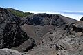
Crater del Hoyo Negro, 2008
-
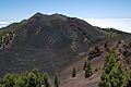
The lava lake La Malforada with Montaña del Fraile, in the background Vulcano Deseada, 2008
-
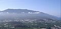
Cumbre Vieja, in 2004, viewed from the north-west
