
La Palma facts for kids
_La_Palma_%26_La_Gomera_Islands,_Canary_Islands_(cropped).jpg)
Satellite view of La Palma
|
|
 |
|
| Geography | |
|---|---|
| Location | Atlantic Ocean |
| Coordinates | 28°40′N 17°52′W / 28.667°N 17.867°W |
| Archipelago | Canary Islands |
| Area | 708.32 km2 (273.48 sq mi) |
| Coastline | 166 km (103.1 mi) |
| Highest elevation | 2,423 m (7,949 ft) |
| Highest point | Roque de los Muchachos |
| Administration | |
|
Spain
|
|
| Autonomous Community | Canary Islands |
| Province | Santa Cruz de Tenerife |
| Capital city | Santa Cruz de La Palma |
| Largest settlement | Los Llanos de Aridane (pop. 20,467 (2019)) |
| Demographics | |
| Demonym | palmero/a |
| Population | 82,671 (2019) |
| Pop. density | 116.7 /km2 (302.3 /sq mi) |
| Languages | Spanish, specifically Canarian Spanish |
| Ethnic groups | Spanish, other minority groups |
| Additional information | |
| Time zone |
|
| • Summer (DST) | |
La Palma, also called San Miguel de La Palma, is the most north-westerly island in the Canary Islands, Spain. It covers about 708 square kilometers (273 square miles). This makes it the fifth largest of the seven main Canary Islands. In early 2019, about 82,671 people lived on La Palma. The capital city is Santa Cruz de la Palma, with about 15,716 residents. The largest city is Los Llanos de Aridane, with about 20,467 people. La Palma is a "sister city" with El Dorado Hills, California. The island's highest point is the Roque de los Muchachos, which is 2,423 meters (7,949 feet) tall. It is the second highest peak in the Canary Islands, after the Teide volcano on Tenerife.
Contents
What is La Palma?
How La Palma was Formed: Volcanoes and Geology
La Palma is a volcanic island in the Atlantic Ocean. Like the other Canary Islands, it was formed by volcanoes erupting underwater. The volcano rises almost 7 kilometers (4.3 miles) from the ocean floor. Its highest peaks are over 2,400 meters (7,874 feet) above sea level. The base of the island is nearly 4,000 meters (13,123 feet) below sea level.
The northern part of La Palma has a huge bowl-shaped area called the Caldera de Taburiente. This "caldera" is 9 kilometers (5.6 miles) wide and 1,500 meters (4,921 feet) deep. It is surrounded by mountains that are 1,600 to 2,400 meters (5,249 to 7,874 feet) high. Inside the caldera is the Caldera de Taburiente National Park. You can only reach the inner part of the caldera by hiking through a deep ravine.
From the Caldera de Taburiente, a ridge called Cumbre Nueva runs south. Despite its name, "New Ridge," it is older than the Cumbre Vieja ("Old Ridge"). The southern part of La Palma is made up of the Cumbre Vieja. This is a volcanic ridge with many cones made of lava and ash. The Cumbre Vieja is an active volcano, but it is currently sleeping. Its last eruption was in 1971 at the Teneguía vent.
Volcanic Activity on La Palma

.jpg)


La Palma formed about three to four million years ago. It is one of the most volcanically active Canary Islands, along with Tenerife. About half a million years ago, the Taburiente volcano collapsed. This created the large Caldera de Taburiente.
Since people started keeping records, there have been seven volcanic eruptions on La Palma. All of these eruptions happened on the Cumbre Vieja ridge:
- 1470–1492 Montaña Quemada
- 1585 Tajuya near El Paso
- 1646 Volcán San Martin
- 1677 Volcán San Antonio
- 1712 El Charco
- 1949 Volcán Nambroque
- 1971 Volcán Teneguía
During the 1949 eruption, an earthquake caused a crack to form. This crack was about 2.5 kilometers (1.5 miles) long. Scientists have studied this crack. There is no sign that the side of the volcano is in danger of breaking off.
La Palma's Climate: Weather and Sunshine
La Palma has a mild and steady tropical semi-arid climate. This means it's generally warm and dry. However, it also has wet winters, similar to a mediterranean climate. The island often has cloudy weather because it gets a lot of moist air from the ocean.
| Climate data for La Palma Airport 33m (1981–2010) | |||||||||||||
|---|---|---|---|---|---|---|---|---|---|---|---|---|---|
| Month | Jan | Feb | Mar | Apr | May | Jun | Jul | Aug | Sep | Oct | Nov | Dec | Year |
| Record high °C (°F) | 27.0 (80.6) |
31.0 (87.8) |
32.8 (91.0) |
36.6 (97.9) |
32.4 (90.3) |
29.4 (84.9) |
38.4 (101.1) |
38.0 (100.4) |
36.8 (98.2) |
34.4 (93.9) |
31.6 (88.9) |
28.1 (82.6) |
38.4 (101.1) |
| Mean daily maximum °C (°F) | 20.6 (69.1) |
20.7 (69.3) |
21.2 (70.2) |
21.6 (70.9) |
22.6 (72.7) |
24.1 (75.4) |
25.5 (77.9) |
26.3 (79.3) |
26.6 (79.9) |
25.5 (77.9) |
23.5 (74.3) |
21.8 (71.2) |
23.3 (74.0) |
| Daily mean °C (°F) | 18.1 (64.6) |
18.0 (64.4) |
18.5 (65.3) |
18.9 (66.0) |
20.0 (68.0) |
21.7 (71.1) |
23.1 (73.6) |
23.9 (75.0) |
24.0 (75.2) |
22.8 (73.0) |
20.9 (69.6) |
19.3 (66.7) |
20.8 (69.4) |
| Mean daily minimum °C (°F) | 15.5 (59.9) |
15.3 (59.5) |
15.7 (60.3) |
16.2 (61.2) |
17.4 (63.3) |
19.2 (66.6) |
20.7 (69.3) |
21.4 (70.5) |
21.3 (70.3) |
20.2 (68.4) |
18.3 (64.9) |
16.7 (62.1) |
18.2 (64.7) |
| Record low °C (°F) | 9.4 (48.9) |
10.9 (51.6) |
10.2 (50.4) |
10.0 (50.0) |
11.0 (51.8) |
15.2 (59.4) |
14.9 (58.8) |
16.7 (62.1) |
16.4 (61.5) |
15.3 (59.5) |
10.0 (50.0) |
10.0 (50.0) |
9.4 (48.9) |
| Average rainfall mm (inches) | 49 (1.9) |
57 (2.2) |
33 (1.3) |
19 (0.7) |
7 (0.3) |
2 (0.1) |
1 (0.0) |
1 (0.0) |
12 (0.5) |
41 (1.6) |
70 (2.8) |
80 (3.1) |
372 (14.5) |
| Average rainy days | 5 | 4 | 4 | 3 | 1 | 0 | 0 | 0 | 2 | 5 | 7 | 8 | 40 |
| Mean monthly sunshine hours | 141 | 146 | 177 | 174 | 192 | 188 | 222 | 209 | 187 | 175 | 140 | 138 | 2,106 |
| Source: Agencia Estatal de Meteorología | |||||||||||||
Island Names and Government
What La Palma is Called
In Spanish, the island is called "Isla de la Palma." This means "Island of Palms" or "Palm Island." People often just call it "La Palma." It is also nicknamed "Isla Bonita" ("beautiful island") or "Isla Verde" ("green island").
How La Palma is Governed
La Palma is part of the province of Santa Cruz de Tenerife. The island is divided into 14 smaller areas called municipalities. Each municipality has its own local government.
| Name | Area (km2) |
Population (2019) |
|---|---|---|
| Barlovento | 43.55 | 1,876 |
| Breña Alta | 30.82 | 7,204 |
| Breña Baja | 14.20 | 5,690 |
| Fuencaliente de la Palma | 56.42 | 1,722 |
| Garafía | 103.00 | 1,667 |
| Los Llanos de Aridane | 35.79 | 20,467 |
| El Paso | 135.92 | 7,622 |
| Puntagorda | 31.10 | 2,110 |
| Puntallana | 35.12 | 2,506 |
| San Andrés y Sauces | 42.75 | 4,141 |
| Santa Cruz de la Palma | 43.38 | 15,716 |
| Tazacorte | 11.37 | 4,575 |
| Tijarafe | 53.76 | 2,532 |
| Villa de Mazo | 71.17 | 4,843 |
| Totals | 708.36 | 82,671 |
Economy and Daily Life
How People Make a Living: Economy
The main ways people earn money on La Palma are through farming and tourism. Plátanos (or bananas) are a very important crop. Many banana farms are on the western side of the island. Other crops include:
- Strelitzia (bird of paradise) flowers
- Oranges
- Avocados
- Grapes (which grow well in the volcanic soil)
The wine made from the grapes is also very popular. Local farmers also raise cows, sheep, and goats. They use the goat milk to make goat cheese. Fishermen catch fish for the local markets from towns like Santa Cruz, Tazacorte, and Puerto Naos.
Plants and Animals of La Palma
Unique Plants on the Island
La Palma has many different kinds of plants. Some of these plants are found only on this island. Even though some forests have been cut down, the higher areas of La Palma still have special evergreen temperate cloud forests. These are called laurisilva (laurel forests). They have trees like Laurus azorica, Persea indica, and Ocotea foetens. These forests are like ancient forests that used to cover the island millions of years ago.
The Canary Island pine (Pinus canariensis) grows on all the western Canary Islands. It is especially common on La Palma. In these pine forests, you can find two very rare plants: Lotus eremiticus and L. pyranthus.
Spartocytisus supranubius, also known as Retama del Teide, is a white-flowered broom plant. It grows only on La Palma and Tenerife in high mountain areas. La Palma also has its own type of alpine violet, Viola palmensis.
Echium pininana (Tree echium) is a plant found only on La Palma. It is the tallest of its kind, growing over 4 meters (13 feet) high. It is related to Echium wildpretii, which grows on Tenerife and La Palma. Both plants grow a huge flower stalk once in their lives. Echium webbii is another plant found only on the island.
The daisy family has several plants found only on La Palma. These include Sonchus palmensis, Argyranthemum haouarytheum, Pericallis papyracea, and Cheirolophus sventenii.
Animals Living on La Palma
Many animals are native to or found only on La Palma. These include:
- The La Palma giant lizard, which was thought to be extinct but was found again in 2007.
- The Western Canaries lizard (Gallotia galloti subspecies palmae).
- The Graja (Pyrrhocorax pyrrhocorax barbarus), a type of red-billed chough.
- The Canary Islands chiffchaff (Phylloscopus canariensis).
- The La Palma chaffinch (Fringilla coelebs palmae).
- The Western Canary Islands goldcrest (Regulus regulus ellenthalerae).
- The Canary Islands quail (Coturnix gomerae), which is now extinct.
Some animals, like rabbits and Barbary sheep, have been brought to the island by humans. These animals can sometimes harm the native plants.
La Palma was named a biosphere reserve in 1983. This means it is a special area recognized for its unique natural environment.
Natural Symbols of La Palma
The official natural symbols of La Palma are the Pyrrhocorax pyrrhocorax barbarus (Graja bird) and the Pinus canariensis (Canary Island pine tree).
History of La Palma
Early Inhabitants of La Palma
Before Europeans arrived, the Canary Islands were home to native people called Canarians. The people of La Palma were known as Auaritas. Their origins are not fully clear, but they are thought to be related to the Berbers of North Africa. The Auaritas had a simple culture, living in clans led by chiefs. Their name for La Palma was Benahoare. We can still see signs of their culture today, like their cave homes, mysterious petroglyphs (rock carvings), and stone paths in the mountains. After the Spanish took over La Palma, the native Canarians either died, were sold into slavery, or became part of the Spanish population.
European Arrival and Conquest
It is believed that the Phoenicians and Greeks knew about the Canary Islands long ago. The earliest written record is from the Roman writer Pliny The Elder. In 1312, a navigator from Genoa named Lancelotto Malocello reached the islands. He stayed for twenty years until the natives fought back and made him leave.
In 1404, the Spanish began to conquer the Canary Islands. The first Spanish landing on La Palma was in 1405. However, it took until 1493 and many bloody battles to finally defeat the native resistance. The Spanish conqueror of La Palma was Alonso Fernández de Lugo. He defeated Tanausu, who was the last king on the island. Tanausu ruled the area known as Acero, which is the Caldera de Taburiente. Tanausu was tricked into a meeting and captured by Fernández de Lugo.
For the next two hundred years, towns on La Palma became rich. The island was an important stop for ships traveling to the New World (the Americas). People from different parts of Spain and Portugal came to live on La Palma.
Culture and Traditions
Religion and Festivals
Most people on La Palma are Roman Catholic. Since 1676, the island has been famous for a special festival. It is called the Fiestas Lustrales de la Bajada de la Virgen de las Nieves. This means "the bringing down of the Virgin of the Snow" (Virgen de las Nieves). This festival happens every five years and has a long history.
A highlight of the festival is the dancing of "enanos" or midgets. People wear special costumes that make them look like dancing midgets. People from all over the world come to see this celebration. The statue of the Virgin Mary is carried from her church outside Santa Cruz de La Palma. She is paraded around the city for almost two weeks before being returned. The last festival was in 2015, and the next one will be in 2020.
The Virgin of the Snow is the patron saint of La Palma. Many women on the island are named "Nieves" in her honor. Every year on August 5th, there is an annual festival for the Virgin.
Getting Around La Palma
Roads and Transportation
La Palma has a road network of about 1,200 kilometers (746 miles). All the main roads are paved and in good condition. However, many roads have sharp turns and some are very narrow. To reach some small villages in the north, you might need to drive on dirt roads. A good paved road, about 180 kilometers (112 miles) long, goes all the way around the island. There are also several bus routes that connect the main towns.
There is a road that goes from Los Llanos de Aridane to the capital city, Santa Cruz de La Palma. This road has two lanes and includes two tunnels that go through the top of the mountain. The older tunnel is 1,100 meters (3,609 feet) long, and the newer one is 2,880 meters (9,449 feet) long. When you travel through these tunnels, you might enter one side in thick clouds and come out to sunshine on the other side. This happens because the clouds cannot cross the mountains due to the wind.
La Palma Airport serves the island, with flights from several airlines. There is also a ferry service to and from the island in Santa Cruz.
Water Tunnels: How La Palma Gets Water
The most famous structures on La Palma are the minas galerias, or water tunnels. These tunnels carry water from mountain sources to cities, villages, and farms. La Palma gets most of its water from the mar de nubes (sea of clouds). This is a layer of clouds that forms between 1,200 and 1,600 meters (3,937 and 5,249 feet) high. The clouds are carried by the wind from the northeast.
The water from these clouds condenses on the long needles of pine trees and other plants. It then drips onto the ground or runs down tree trunks. This water collects inside the rocks. The galerias are tunnels dug into the rocks over many centuries to collect this water. You need a permit to visit the galerias. Walking along the aqueducts (water channels) is a popular activity for tourists.
In the valley of Los Llanos de Aridane, there is a large network of irrigation canals. These canals bring water from the mountains to farms. This allows farmers to grow bananas, avocados, flowers, and other plants. Each farmer gets a scheduled time to fill their irrigation tank with water.
Observing the Stars: Observatories

Because of the island's location and the height of its mountains (about 2,400 meters or 7,874 feet above sea level), many international observatories have been built on the Roque de los Muchachos. The special geography and climate cause clouds to form between 1,000 and 2,000 meters (3,281 and 6,562 feet) high. This usually leaves the observatories with a clear sky above. Often, from the top of the volcano, you can see a "sea of clouds" covering the eastern part of the island.
Some of the telescopes at the observatory include:
- The Isaac Newton Group of Telescopes (ING) has three telescopes, including the 4.2-meter (13.8-foot) William Herschel Telescope.
- The 2.5-meter (8.2-foot) Nordic Optical Telescope (NOT).
- The 1-meter (3.3-foot) Swedish Solar Telescope (SST), which studies the Sun.
- The 0.45-meter (1.5-foot) Dutch Open Telescope (DOT), also for studying the Sun.
- The 10.4-meter (34.1-foot) Gran Telescopio Canarias (Great Canary Telescope), one of the largest optical telescopes in the world.
- The 3.6-meter (11.8-foot) Telescopio Nazionale Galileo (TNG).
- The 17-meter (55.8-foot) MAGIC Telescope, which observes high-energy gamma rays.
- The SuperWASP-North telescope, which looks for planets outside our solar system.
Images for kids
-
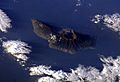
Satellite image of La Palma, with the Caldera de Taburiente visible (north is to the lower right)
-
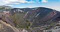
Crater of San Antonio volcano (last erupted 1677)
-
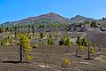
Pico Birigoyo is the northernmost of the high volcanic peaks along the Cumbre Vieja
-
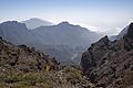
Walls of Caldera de Taburiente
-
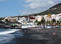
Black sand beach in Puerto Naos
-
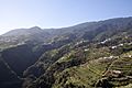
Terraced fields in La Palma
-
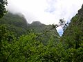
Laurisilva cloud forest in La Palma
-
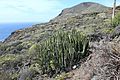
Euphorbia canariensis is a succulent endemic to the Canary Islands
-
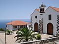
Iglesia Nuestra Señora de La Luz
-
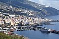
Santa Cruz de La Palma has the only major port in the island

.jpg)

.jpg)

.jpg)


_03_ies.jpg)
See also
 In Spanish: La Palma para niños
