Los Llanos de Aridane facts for kids
Quick facts for kids
Los Llanos de Aridane
|
|||
|---|---|---|---|
|
City
|
|||
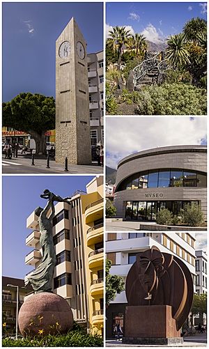
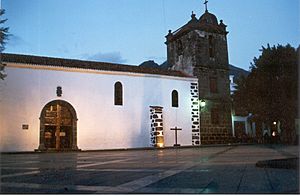
Top left:Los Llanos de Aridane Clock Tower, Top right:Antonio Gomez Felipe Park, Middle right:Benahorita Archaeological Museum, Bottom left:La Madre Monument in Carlos Francisco Lorenzo Navarro Square, Bottom right:El Guanche Monument in Dr. Fleming Street
|
|||
|
|||
 |
|||
| Country | |||
| Region | Canary Islands | ||
| Province | Santa Cruz de Tenerife | ||
| Island | La Palma | ||
| Area | |||
| • Total | 35.79 km2 (13.82 sq mi) | ||
| Elevation | 340 m (1,120 ft) | ||
| Population
(2018)
|
|||
| • Total | 20,171 | ||
| • Density | 563.59/km2 (1,459.70/sq mi) | ||
| Demonym(s) | Llanense | ||
| Postal code |
38760
|
||
| Website | www.aridane.org | ||
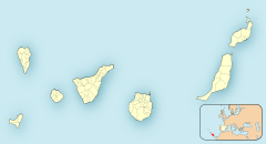
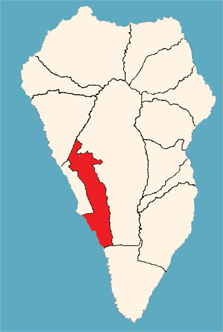
Los Llanos de Aridane is a lively town located on the island of La Palma in the Canary Islands, Spain. It's part of the Province of Santa Cruz de Tenerife. You can find it on the western side of La Palma, in a beautiful area called the Aridane Valley. It's the biggest town on La Palma, with over 20,000 people living there.
Contents
History of Los Llanos
The town of Los Llanos was officially created in August 1812. Back then, it was a much larger area. It included other towns like El Paso, Tazacorte, and Argual.
Over time, some of these towns became separate. In 1837, El Paso became its own town. Later, in 1925, Tazacorte also separated from Los Llanos. At that time, Tazacorte was the largest and most developed part of the area.
Geography and Economy
Los Llanos de Aridane covers an area of about 35.79 square kilometers (about 13.8 square miles). The town is located about 325 meters (1,066 feet) above sea level. It also has a coastline that stretches for about 6.43 kilometers (4 miles).
The main neighborhoods in Los Llanos de Aridane include:
- Los Llanos
- Argual
- Montaña Tenisca
- El Roque
- Los Barros
- La Laguna
- Todoque
- Las Manchas de Abajo
- Puerto Naos
- Triana
- Retamar Jedey
- El Remo
The town is very important for the island's economy. It mainly relies on growing bananas and on tourism.
Places to Visit
Los Llanos de Aridane has many interesting places to explore.
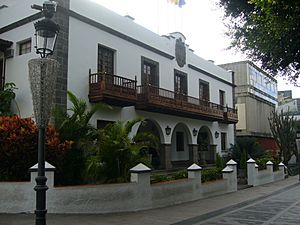
City Hall
The City Hall building is where the local government works. It was built starting in 1945. The building has a special regional style designed by architect Tomas Machado. You can see beautiful balconies and a unique window with a Mudejar-style lattice. Inside, there are seven oil paintings by Antonio Palma Suarez Gonzalez. These paintings show important historical events and scenes.
Plaza de España
The Plaza de España, or Spain Square, is the heart of the town. It's a central spot for administration, fun, and meeting up. Many important buildings are located around this square. The plaza was updated in the year 2000, making the surrounding streets pedestrian-friendly. This has made the area very lively.
Around the plaza, you'll find 11 amazing Indian laurel trees. These trees, along with royal palm trees, were brought from Cuba by people returning home in the mid-1800s. They wanted to make their hometown more beautiful. These old laurel trees have become a symbol of the city. They are also some of the oldest trees on the island.
Llano de Argual
Llano de Argual is a historic area where the economy of the Aridane Valley first began to grow. It shows how rich the area once was. This was thanks to using water from La Caldera to water sugarcane fields, and now banana farms. In El Llano, there are four old mansions from the 1600s and 1700s:
- Ontanilla Velez home
- Massieu Van Dalle house (now an exhibition center and tourist office)
- Poggio Maldonado home
- Sotomayor house (the oldest one still standing)
Plaza de Los Cuatro Caminos
This plaza, also known as a viewpoint, was designed by the artist Luis Morera. It was built between 1993 and 1996. It's known for its beautiful mosaic artwork. The benches and pergolas are covered with ceramic tiles. There's also a stage made of lava stones and plants native to the Canary Islands.
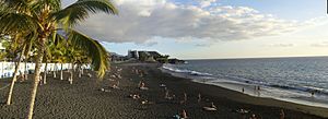
Puerto Naos Beach
Puerto Naos beach is on the west side of the island. It has warm temperatures all year round. This beach has won the Blue Flag award because of its good services and clear water. There's a boardwalk along the black sand beach. You can walk there or sit at a cafe to watch the sea and the sunset.
Charco Verde Beach
Charco Verde beach is a small cove with black sand, located south of Puerto Naos. There's an old hot spring here that people once used for its healing properties. This beach also received the Blue Flag award for the first time in 2009.
Education in Los Llanos
The town has a good education system, from early childhood to university. Public schools are managed by the Ministry of Education of the Canary Government.
Primary Schools
Some of the primary schools include:
- CEIP El Roque
- C.E.I.P. Mayantigo
- C.E.I.P. Puerto Naos
- C.E.I.P. Tajuya
- C.E.I.P. Todoque
- C.E.I.P. 25 Years of Peace
- C.E.I.P. Las Manchas
- C.E.I.P. Los Campitos
Secondary Schools and Other Centers
There are two main secondary schools:
- IES Eusebio Barreto Lorenzo
- I.E.S. Jose Maria Perez Pulido
Other educational centers include:
- The Agricultural Training School in Los Llanos
- The College of Special Education Acerina Princess
- The Official Language School of Los Llanos
For university studies, Los Llanos has a branch of the National University of Distance Education (UNED).
There is also one private school, the Holy Family of Nazareth School. It offers education for children from early years through primary and secondary levels.
Libraries
Los Llanos has two libraries. The main library is located in the House of Culture in the town. The other library is in the Cultural Center of Argual. Both libraries work together to share resources and knowledge. They aim to improve education and culture in the city.
Population Over Time
| Year | Population |
|---|---|
| 1991 | 16,189 |
| 1996 | 17,994 |
| 2001 | 17,720 |
| 2002 | 20,238 |
| 2003 | 20,001 |
| 2004 | 19,659 |
| 2013 | 20,930 |
See also
 In Spanish: Los Llanos de Aridane para niños
 | Toni Morrison |
 | Barack Obama |
 | Martin Luther King Jr. |
 | Ralph Bunche |


