
Puʻukoholā Heiau National Historic Site facts for kids
Quick facts for kids |
|
|
Puʻukoholā Heiau National Historic Site
|
|
 |
|

Location in Hawaii
|
|
| Location | Hawaii County, Hawaii, USA |
|---|---|
| Nearest city | Waimea |
| Area | 76.6 acres (31.0 ha) |
| Architect | Kamehameha I |
| Architectural style | Ancient Hawaiian |
| Visitation | 134,403 (2012) |
| Website | Puʻukoholā Heiau National Historic Site |
| NRHP reference No. | 66000105 |
| Significant dates | |
| Added to NRHP | October 15, 1966 |
| Designated NHL | December 29, 1962 |
| Battle of Kawaihae | |||||||
|---|---|---|---|---|---|---|---|
| Part of Unification of Hawaii | |||||||
|
|||||||
| Belligerents | |||||||
| Kamehameha I's army | Keōua Kuahuʻula | ||||||
| Commanders and leaders | |||||||
| Kamehameha I | Keōua Kuahuʻula | ||||||

Puʻukoholā Heiau National Historic Site is a special place on the northwestern coast of the Big Island of Hawaiʻi. It protects the amazing ruins of the last big ancient Hawaiian temple. This site also holds other important historical spots. The name Puʻukoholā means "Temple on the Hill of the Whale." It reminds us of a time when powerful kings shaped the islands.
Contents
Building a Special Temple
King Kamehameha's Dream
In 1782, King Kamehameha I took control of parts of Hawaiʻi Island. For eight years, he fought many battles. He wanted to unite all the Hawaiian Islands under one rule. After returning from Maui in 1790, his cousin Keōua Kuahuʻula attacked him. Keōua still controlled the eastern side of the island.
Kamehameha went back to Kawaihae village. There, a wise priest, called a kahuna, named Kapoukahi gave him advice. The priest suggested building a special temple, a luakini heiau, to honor the war god Kūkaʻilimoku. This would help Kamehameha win his battles.
How the Temple Was Built
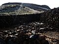
The Puʻukoholā Heiau was built on the site of an older temple. It was made entirely by hand, without any mortar. Thousands of people worked together for less than a year. They moved red stones about 14 miles from Pololū Valley. A long line of people passed the stones from hand to hand. Kamehameha's brother, Keliʻimaikaʻi, oversaw the huge project.
New Friends and New Weapons
In 1790, a ship called the Fair American was captured. One sailor, Isaac Davis, survived. Another British sailor, John Young, was also stranded. These two men became important advisors to King Kamehameha. They taught his army how to use muskets and cannons. John Young even built a house and ranch nearby. This area is now part of the historic site.
News of Kamehameha's growing power reached other islands. They formed an alliance and tried to invade from the northeast. But Kamehameha's army, with their new weapons, was ready. They used cannons mounted on double-hulled canoes. The invaders were defeated in a battle north of Waipiʻo Valley.
Uniting the Hawaiian Islands
The Final Battle for Unity
By the summer of 1791, the massive temple was finished. It was about 224 feet long and 100 feet wide. Kamehameha invited his cousin Keōua Kuahuʻula to a meeting. He offered a peace treaty. It is not fully clear why Keōua accepted. Perhaps he felt he had no other choice. He had lost many warriors in earlier battles and a volcanic eruption.
When Keōua arrived, he and his group were captured. The new temple was then officially dedicated. This event helped Kamehameha continue his goal to unite all the islands. He conquered Maui in 1794 and Oʻahu in 1795. The last island, Kauaʻi, joined peacefully in 1810. This made Kamehameha I the first king of a unified Hawaiʻi.
This important battle is sometimes called the "Slaughter at Kawaihae." In 1991, on its 200th anniversary, a special healing ceremony was held here. Descendants of those involved came together.
Important Visitors to Hawaii
John Young continued to be an important interpreter for Kamehameha. In 1793, the British explorer George Vancouver visited the site. He left cattle, which helped start the ranching industry in Hawaii.
What You Can See Today
Today, the National Park Service runs a visitor center at the site. A walking trail starts there and leads to Puʻukoholā. Visitors can see the temple from a distance. However, people are not allowed to enter the temple itself. This is because ancient bones are believed to be buried there.
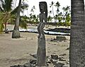
About 170 feet west of Puʻukoholā are the ruins of an older temple, Mailekini Heiau. John Young later turned this into a fort to protect the harbor. Just offshore, there is an underwater structure called Hale o Kapuni. It was dedicated to sharks. A stone post, called a pōhaku, marks a spot where people could watch sharks being fed. Across the bay, you can see the modern Kawaihae harbor.
Puʻukoholā Heiau became a National Historic Landmark in 1962. It was added to the National Register of Historic Places in 1966. In 2000, its name was officially changed to reflect the correct Hawaiian spelling.
Images for kids
-
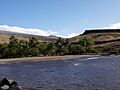
Puʻukoholā Heiau view from the beach
-
Puʻukoholā Heiau
-
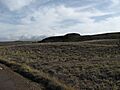
The Hill of the Whale
-
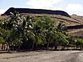
Palms at Puʻukoholā Heiau
-
Mailekini Heiau


.jpg)
