
Hawaii County, Hawaii facts for kids
Quick facts for kids
Hawaii County
|
||
|---|---|---|

|
||
|
||

Location within the U.S. state of Hawaii
|
||
 Hawaii's location within the U.S. |
||
| Country | ||
| State | ||
| Founded | 1905 | |
| Named for | Hawaii (Island) | |
| Seat | Hilo | |
| Largest community | Hilo | |
| Area | ||
| • Total | 5,086.70 sq mi (13,174.5 km2) | |
| • Land | 4,028.02 sq mi (10,432.5 km2) | |
| • Water | 1,058.69 sq mi (2,742.0 km2) 20.81% | |
| Population
(2020)
|
||
| • Total | 200,629 | |
| • Density | 46/sq mi (17.7/km2) | |
| Time zone | UTC−10 (Hawaii–Aleutian) | |
| • Summer (DST) | HADT | |
| Congressional district | 2nd | |

Hawaii County is a special part of the U.S. state of Hawaii. It's officially called the County of Hawaiʻi (or Kalana o Hawaiʻi in Hawaiian). This county covers the entire Island of Hawaii, which people often call the "Big Island." This helps avoid confusion with the whole state of Hawaii.
In 2020, about 200,629 people lived in Hawaii County. The main town and government center is Hilo. Unlike many places, Hawaii County doesn't have any separate cities or towns that are officially "incorporated." The whole county is considered one large area for government purposes.
Hawaii County is the largest county in Hawaii by land area. It's also the southernmost county in the entire United States! The county is led by a mayor and a council. The current mayor is Kimo Alameda, who started his term in 2024. Nine council members help make decisions for the county.
Did you know? Hawaii County is one of only seven counties in the U.S. that has the same name as its state!
Contents
Exploring Hawaii County's Geography
Hawaii County is truly huge! It covers a total area of about 5,087 square miles. Most of this (about 4,028 square miles) is land. The rest (about 1,059 square miles) is water, mostly the ocean around the island.
The land area of Hawaii County makes up a big part of the entire state's land. It's about 62.7% of all the land in Hawaii! This is the highest percentage for any county in the United States.
Main Roads and Travel
Getting around Hawaii County is easy with these important highways:
- Route 11
- Route 19
- Route 130
- Route 132
- Route 137
- Route 190
- Route 200
- Route 250
- Route 270
- Route 2000
Neighboring Areas
Hawaii County shares a border with only one other county:
- Maui County - to the northwest
People of Hawaii County
The number of people living in Hawaii County has grown a lot over the years!
| Historical population | |||
|---|---|---|---|
| Census | Pop. | %± | |
| 1900 | 46,843 | — | |
| 1910 | 55,382 | 18.2% | |
| 1920 | 64,895 | 17.2% | |
| 1930 | 73,325 | 13.0% | |
| 1940 | 73,276 | −0.1% | |
| 1950 | 68,350 | −6.7% | |
| 1960 | 61,332 | −10.3% | |
| 1970 | 63,468 | 3.5% | |
| 1980 | 92,053 | 45.0% | |
| 1990 | 120,317 | 30.7% | |
| 2000 | 148,677 | 23.6% | |
| 2010 | 185,079 | 24.5% | |
| 2020 | 200,629 | 8.4% | |
| 2023 (est.) | 207,615 | 12.2% | |
In 2010, there were 185,079 people living on the island. The population density was about 46 people per square mile. There were over 64,000 households. About 32% of these households had children under 18 living there. The average household had about 2.75 people.
The median age of people in Hawaii County was 39 years old. This means half the people were younger than 39, and half were older.
Many different cultures live together in Hawaii County. The largest groups include people of White, Asian, and Native Hawaiian or Pacific Islander backgrounds. Many people also have mixed backgrounds.
Towns and Communities
Hawaii County has many unique towns and communities. Some are called "census-designated places" (CDPs), which are areas identified for statistics. Others are smaller communities.
Census-Designated Places
- Ainaloa
- Black Sands
- Captain Cook
- Discovery Harbour
- Eden Roc
- Fern Acres
- Fern Forest
- Halaula
- Hawaiian Acres
- Hawaiian Beaches
- Hawaiian Ocean View
- Hawaiian Paradise Park
- Hawi
- Hilo
- Holualoa
- Honalo
- Honaunau-Napoopoo
- Honokaa
- Honomu
- Kahaluu-Keauhou
- Kailua
- Kaiminani
- Kalaoa
- Kalapana
- Kaloko
- Kamaili
- Kapaau
- Keaau
- Kealakekua
- Kukuihaele
- Kurtistown
- Laupahoehoe
- Leilani Estates
- Mauna Loa Estates
- Mountain View
- Naalehu
- Nanawale Estates
- Orchidlands Estates
- Paauilo
- Pahala
- Pahoa
- Papaikou
- Paukaa
- Pepeekeo
- Puako
- Royal Hawaiian Estates
- Seaview
- Tiki Gardens
- Volcano
- Volcano Golf Course
- Waikoloa Beach Resort
- Waikoloa Village
- Waimea
- Wainaku
- Waiohinu
Other Communities
Amazing Natural Places
Hawaii County is home to several beautiful and important protected areas:
- Ala Kahakai National Historic Trail
- Hakalau Forest National Wildlife Refuge
- Hawaii Volcanoes National Park
- Kaloko-Honokōhau National Historical Park
- Kona Forest National Wildlife Refuge
- Puʻuhonua o Hōnaunau National Historical Park
- Puʻukoholā Heiau National Historic Site
Jobs and Economy
Many people work in Hawaii County. Here are some of the biggest employers:
| # | Employer | # of Employees |
|---|---|---|
| 1 | State of Hawaii | 16,700 |
| 2 | Kamehameha Schools, Hawai'i Island | 3,380 |
| 3 | Hawaii County | 2,800 |
| 4 | United States Government | 1,300 |
| 5 | Mauna Kea Beach Hotel | 1,100 |
| 6 | Four Seasons Resort Hualalai | 1,003 |
| 7 | KTA Super Stores | 900 |
| 8 | Hilton Waikoloa Village | 850 |
| 9 | The Fairmont Orchid | 560 |
| 10 | Waikoloa Beach Marriott Resort | 259 |
Learning and Education
Hawaii County has great places for learning:
- University of Hawaiʻi at Hilo
- University of the Nations
- Hawaiʻi Community College
Public schools in Hawaii County are managed by the Hawaii Department of Education.
Sister Cities Around the World
Hawaii County has special connections with cities in other countries. These are called "sister cities," and they help promote friendship and understanding.
Images for kids
-
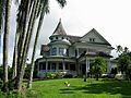
The historic W. H. Shipman House in Hilo.
See also
 In Spanish: Condado de Hawái para niños
