Honalo, Hawaii facts for kids
Quick facts for kids
Honalo, Hawaii
|
|
|---|---|

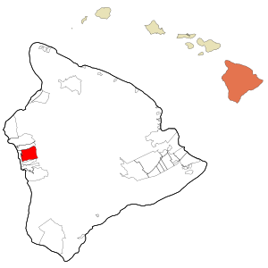
Location in Hawaii County and the state of Hawaii
|
|
| Country | United States |
| State | Hawaii |
| County | Hawaii |
| Area | |
| • Total | 27.17 sq mi (70.38 km2) |
| • Land | 27.17 sq mi (70.38 km2) |
| • Water | 0.00 sq mi (0.00 km2) |
| Elevation | 1,391 ft (424 m) |
| Population
(2020)
|
|
| • Total | 996 |
| • Density | 36.65/sq mi (14.15/km2) |
| Time zone | UTC-10 (Hawaii-Aleutian) |
| Area code(s) | 808 |
| FIPS code | 15-16000 |
| GNIS feature ID | 0359266 |
Honalo is a small community located in Hawaii County on the beautiful island of Hawaii in the United States. It's known as a "census-designated place" (CDP). This means it's an area identified by the government for statistics, but it's not a formally incorporated town with its own local government.
In 2020, about 996 people lived in Honalo. The population was 2,423 in 2010, and 1,987 in 2000.
Where is Honalo?
Honalo is found on the western side of the island of Hawaii. Its exact location is 19°33′34″N 155°55′47″W / 19.55944°N 155.92972°W. This means it's at 19.559309 degrees north latitude and 155.929832 degrees west longitude.
The community is surrounded by other places. To the north, you'll find Holualoa. To the south is Kealakekua. To the west, it borders Kahaluu-Keauhou.
Roads and Travel
Hawaii Route 11 is a main road that goes through the western part of Honalo. This road can take you about 7 miles (11 km) north to Kailua-Kona. If you head south on Route 11, it's about 51 miles (82 km) to Naalehu.
Another road, Hawaii Route 180, branches off Route 11 in Honalo. This secondary road runs to the east of Route 11.
Area Size
According to the United States Census Bureau, the Honalo area covers about 76.6 square kilometers (29.6 square miles). All of this area is land, with no water.
Honalo's History
An important building in Honalo's history is the Daifukuji Soto Zen Mission. This special place was built in Honalo in the year 1921.
See also
 In Spanish: Honalo para niños
 | James Van Der Zee |
 | Alma Thomas |
 | Ellis Wilson |
 | Margaret Taylor-Burroughs |

