Kahaluʻu-Keauhou, Hawaii facts for kids
Quick facts for kids
Kahaluu-Keauhou, Hawaii
Kahaluʻu-Keauhou
|
|
|---|---|

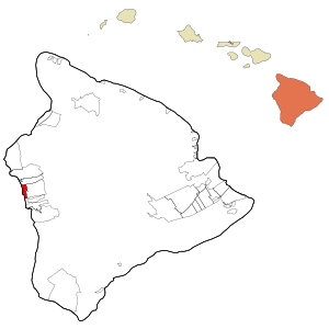
Location in Hawaiʻi County and the state of Hawaiʻi
|
|
| Country | United States |
| State | Hawaii |
| County | Hawaii |
| Area | |
| • Total | 10.28 sq mi (26.63 km2) |
| • Land | 8.01 sq mi (20.74 km2) |
| • Water | 2.27 sq mi (5.89 km2) |
| Elevation | 100 ft (30 m) |
| Population
(2020)
|
|
| • Total | 4,778 |
| • Density | 596.80/sq mi (230.43/km2) |
| Time zone | UTC-10 (Hawaii-Aleutian) |
| Area code(s) | 808 |
| FIPS code | 15-21230 |
| GNIS feature ID | 2414055 |
Kahaluʻu-Keauhou is a special kind of community in Hawaiʻi. It's called a census-designated place (CDP). This means it's an area that the government counts for population, but it's not an official city or town. It's located in Hawaiʻi County, which is part of the United States. In 2010, about 3,549 people lived here. That number grew from 2,414 people in 2000.
Contents
Where is Kahaluʻu-Keauhou?
Kahaluʻu-Keauhou is found on the western side of the big island of Hawaiʻi. You can find its exact spot using these coordinates: 19°34′32″N 155°57′38″W / 19.57556°N 155.96056°W.
Nearby Places
To the north of Kahaluʻu-Keauhou is a place called Holualoa. To its east, you'll find Honalo. The huge Pacific Ocean is to its west. About 5 miles (8 kilometers) south is the town of Kealakekua.
Size of the Area
The total area of Kahaluʻu-Keauhou is about 10.3 square miles (26.6 square kilometers). Most of this area, about 8 square miles (20.7 square kilometers), is land. The rest, about 2.3 square miles (5.9 square kilometers), is water. This means water makes up about 28.89% of the area.
Kahaluʻu Bay
Right on the coast of Kahaluʻu-Keauhou is the historic Kahaluʻu Bay. This bay is a very important place with a lot of history.
How Many People Live Here?
The number of people living in Kahaluʻu-Keauhou has changed over the years.
| Historical population | |||
|---|---|---|---|
| Census | Pop. | %± | |
| 2020 | 4,778 | — | |
| U.S. Decennial Census | |||
In 2000, there were 2,414 people. By 2010, the population grew to 3,549. The most recent count in 2020 showed that 4,778 people live in this community.
See also
 In Spanish: Kahaluu-Keauhou para niños
 | Lonnie Johnson |
 | Granville Woods |
 | Lewis Howard Latimer |
 | James West |

