Mountain View, Hawaii facts for kids
Quick facts for kids
Mountain View, Hawaii
|
|
|---|---|

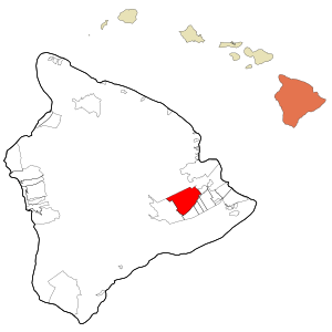
Location in Hawaii County and the state of Hawaii
|
|
| Country | United States |
| State | Hawaii |
| County | Hawaii |
| Area | |
| • Total | 54.95 sq mi (142.32 km2) |
| • Land | 54.95 sq mi (142.31 km2) |
| • Water | 0.00 sq mi (0.01 km2) |
| Elevation | 1,434 ft (437 m) |
| Population
(2020)
|
|
| • Total | 4,215 |
| • Density | 76.71/sq mi (29.62/km2) |
| Time zone | UTC-10 (Hawaii-Aleutian) |
| ZIP code |
96771
|
| Area code(s) | 808 |
| FIPS code | 15-53300 |
| GNIS feature ID | 0362495 |
Mountain View is a special kind of community in Hawaii County, Hawaii, called a census-designated place (CDP). It's located in the District of Puna on the beautiful island of Hawaii. In 2020, about 4,215 people lived here. This number has grown quite a bit from 2,799 people in 2000.
Where is Mountain View?
Mountain View is found on the eastern side of Hawaii, often called the Big Island. Its exact location is 19°32′23″N 155°8′29″W / 19.53972°N 155.14139°W. It shares borders with several other communities. These include Kurtistown to the northeast and Hawaiian Acres to the east. To the southeast, you'll find Fern Acres and Eden Roc. Fern Forest is to the south, and Volcano is to the southwest.
Hawaii Route 11 is a main road that goes through the southeast part of Mountain View. This road can take you about 15 miles north to Hilo. It also leads about 15 miles southwest to the famous Hawaii Volcanoes National Park. The entire area of Mountain View is about 54.95 square miles (142.32 square kilometers), and it's all land.
What's the Weather Like?
Mountain View has a warm and wet climate. It gets a lot of rain throughout the year, especially from November to April. Even so, temperatures are usually pleasant.
| Climate data for Mountain View | |||||||||||||
|---|---|---|---|---|---|---|---|---|---|---|---|---|---|
| Month | Jan | Feb | Mar | Apr | May | Jun | Jul | Aug | Sep | Oct | Nov | Dec | Year |
| Record high °F (°C) | 87 (31) |
86 (30) |
85 (29) |
83 (28) |
84 (29) |
90 (32) |
85 (29) |
88 (31) |
87 (31) |
87 (31) |
84 (29) |
87 (31) |
90 (32) |
| Mean daily maximum °F (°C) | 74.8 (23.8) |
74.1 (23.4) |
73.4 (23.0) |
73.8 (23.2) |
75 (24) |
76.9 (24.9) |
77.2 (25.1) |
78.1 (25.6) |
78.7 (25.9) |
78.2 (25.7) |
76 (24) |
74.5 (23.6) |
75.9 (24.4) |
| Daily mean °F (°C) | 65.8 (18.8) |
65.4 (18.6) |
65.3 (18.5) |
66.1 (18.9) |
67.2 (19.6) |
68.7 (20.4) |
69.4 (20.8) |
70.1 (21.2) |
70.0 (21.1) |
69.6 (20.9) |
68.0 (20.0) |
66.3 (19.1) |
67.7 (19.8) |
| Mean daily minimum °F (°C) | 56.8 (13.8) |
56.6 (13.7) |
57.2 (14.0) |
58.4 (14.7) |
59.3 (15.2) |
60.5 (15.8) |
61.6 (16.4) |
62.1 (16.7) |
61.3 (16.3) |
60.9 (16.1) |
59.9 (15.5) |
58 (14) |
59.4 (15.2) |
| Record low °F (°C) | 43 (6) |
38 (3) |
45 (7) |
47 (8) |
49 (9) |
49 (9) |
52 (11) |
52 (11) |
51 (11) |
48 (9) |
47 (8) |
42 (6) |
38 (3) |
| Average rainfall inches (mm) | 12.69 (322) |
16.99 (432) |
20.88 (530) |
21.14 (537) |
15.62 (397) |
9.69 (246) |
12.88 (327) |
15.29 (388) |
9.92 (252) |
12.84 (326) |
19.79 (503) |
17.87 (454) |
185.6 (4,714) |
| Average precipitation days | 19 | 20 | 25 | 26 | 27 | 25 | 27 | 27 | 23 | 24 | 23 | 23 | 289 |
| Source: WRCC | |||||||||||||
Who Lives in Mountain View?
| Historical population | |||
|---|---|---|---|
| Census | Pop. | %± | |
| 2000 | 2,799 | — | |
| 2010 | 3,924 | 40.2% | |
| 2020 | 4,215 | 7.4% | |
| U.S. Decennial Census | |||
In 2010, there were 3,924 people living in Mountain View. These people lived in 1,318 different homes. The area had about 69 people per square mile.
The community is made up of people from many different backgrounds. About 25% were White, and 16% were Asian. Nearly 10% were Native Hawaiian or Pacific Islander. A large group, about 46%, identified as being from two or more races. Also, about 20% of the population was Hispanic or Latino.
Many homes in Mountain View have children. In 2010, about 35% of households had kids under 18 living there. The average household had almost three people. The population includes people of all ages. About 30% were under 18, and about 21% were between 50 and 64 years old.
See also
 In Spanish: Mountain View (Hawái) para niños
 | Aurelia Browder |
 | Nannie Helen Burroughs |
 | Michelle Alexander |

