
Puna, Hawaii facts for kids


Puna is one of the nine districts in Hawaii County, located on the Big Island of Hawaiʻi. It sits on the east side of the island, known as the "windward" side. Puna shares its borders with the South Hilo district to the north and the Kaʻū district to the west.
Puna is about 500 square miles, which is a bit smaller than the island of Kauaʻi. This area is great for growing things like flowers, plants for nurseries, and macadamia nuts. Most of the state's papayas come from lower Puna, as it's the perfect spot for them to grow.
Because Puna is located on a volcanic rift zone of Kilauea Volcano, it often experiences lava eruptions and flows. For example, the town of Kapoho was completely destroyed by lava during the big 2018 lower Puna eruption.
Contents
Puna's Past: A Look Back
Ancient Times: Kingdom of Hawaii
A map from 1837 by Kalama shows that Puna was once a "Moku." A Moku was a traditional district that covered the southeastern part of the island. This was before the "great mahele," which was a big land division in the Hawaiian Kingdom.
Recent Lava Activity: Kīlauea's Power
Kīlauea is one of the world's most active volcanoes. Until August 2018, it was erupting almost constantly since 1983. Scientists at the Hawaii Volcano Observatory watched it very closely.
Over the years, lava flows have destroyed many areas. The Royal Gardens neighborhood and the villages of Kaimu and Kalapana were mostly covered by lava. In 2014, lava briefly reached the edge of Pahoa, which is the main village in Puna. However, it stopped there and found a new path to the ocean.
Hawaii Volcanoes National Park used to have two entrances. The entrance from lower Puna was cut off in 1986. Several miles of the road along the ocean were buried by lava flows. Millions of tourists used to visit each year to see the amazing sight of lava flowing into the sea. Lava flows also created new land along the coast. Sometimes, this new land was unstable and would break off into the ocean. Visitors could watch from safe viewing spots.
The 2014 Lava Flow
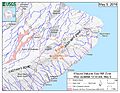
In June 2014, a lava flow started from a vent called Puʻu ʻŌʻō on Kīlauea's east rift zone. This flow, called the June 27th flow, moved northwest toward the villages of Kaohe Homesteads and Pahoa.
In early September, it looked like the lava was heading for Kaohe Homesteads. Community leaders and state officials started planning for evacuations. The mayor even declared an emergency. Residents learned the lava was less than a mile away and could reach them soon. But on September 13, the Hawaiian Volcano Observatory announced that the flow had changed direction. It moved away from the subdivision because of cracks in the ground and a natural valley.
By early October 2014, the lava flow was moving toward Pahoa. On October 25, the lava crossed Cemetery Road near the Pahoa Recycling and Transfer Station. This station had to close and move. The lava quickly moved toward a nearby cemetery, causing the first evacuations. On November 10, the lava destroyed a home.
Officials worried that if the lava kept going, it would cover Highway 130. This was the only road in and out of lower Puna. On October 22, the National Park Service announced they would help build an emergency route. This route would be along 8 miles of the buried Chain of Craters Road. This was to help Puna residents if Highway 130 was covered.
Construction of the emergency route began by clearing a path over old lava rock. This new gravel road, costing $12 million to $15.5 million, would have been the only way in and out of lower Puna if the lava reached the sea. The park closed the end of Chain of Craters Road for construction. About 8 miles of this road had been covered by past lava flows. Chain of Craters Road opened in 1965. For 37 of its 49 years, parts of it were blocked or covered by lava. The road is about 19 miles long inside the park.
The lava flow stopped just before reaching Pahoa village. In 2016, a new flow, called Episode 61G, came from Puʻu ʻŌʻō. It flowed south, the shortest way to the ocean. This new flow cut off the emergency road that connected Highway 130 to Chain of Craters Road. In 2018, this road was cleared again through the 2016 lava. This provided emergency access during the 2018 lower Puna eruption.
The 2018 Eruption
On May 3, 2018, a crack in the ground opened up. Lava started flowing out on Mohala Street in Leilani Estates. By June 5, 2018, officials reported that hundreds of homes in several neighborhoods had been destroyed. The eruption ended in early August. By then, over 13.7 square miles had been covered by lava. This also created about 875 acres of new land offshore.
-
Map of earthquake activity along Kīlauea's East Rift Zone (May 2, 2018)
-
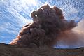
Collapse in the crater of Pu‘u ‘Ō‘ō, creating an ash plume (May 3, 2018)
-
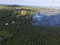
Eruption in the Leilani Estates neighborhood (May 3, 2018)
-
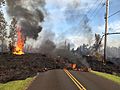
Lava from a crack slowly moved northeast on Hoʻokāpu Street in Leilani Estates (May 5, 2018)
-
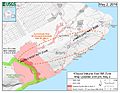
Map showing where the eruptive cracks were (May 5, 2018)


Puna's Geography and Communities
Communities in Puna
The United States Census Bureau has named many of these places "census-designated places" (CDP). This means they are areas defined for counting people, but their boundaries might not exactly match what local people call them.
- ʻĀinaloa
- Black Sands
- Eden Roc
- Fern Acres
- Fern Forest
- Glenwood
- Hawaiian Acres
- Hawaiian Beaches
- Hawaiian Paradise Park
- Kalapana
- Kapoho
- Keaʻau
- Kehena
- Kurtistown
- Leilani Estates
- Mountain View
- Nānāwale Estates
- Orchidland
- Pāhoa
- Vacationland Hawaii
- Volcano Village
Homes in Puna
Puna has seen a huge increase in new homes because prices used to be very affordable. This has made Puna the fastest-growing area on the Big Island. In the last 20 years, the population has grown by almost 20,000 people. It's thought that Puna might even have more people than Hilo by 2020. However, between 2002 and 2006, house prices more than doubled. The price of empty land went up five times. This happened as more people, often from the mainland U.S., bought property in this last affordable market in Hawaii.
Getting Homeowners Insurance can be harder in parts of Puna that are in Lava Flow Hazard Zones 1 or 2. The entire Kīlauea rift zone is in Zone 1, which is the highest risk. The southeastern slope is in Zone 2. Most home insurance companies won't cover homes in Zone 1 or 2 if they are worth more than $350,000.
Most of the volcanic damage to private property in Hawaiʻi since the 1900s has happened in lower Puna. This includes parts of Kapoho, Royal Gardens, Kalapana, and Kaimū. From 1983 until 2018, lava flows destroyed about 190 buildings. They also covered about 50 square miles of Puna's total 500 square miles.
Living in Puna has some other unique things to consider. For example, most homes in Puna collect rainwater for their water supply. This lack of available water for fighting fires is also a concern for insurance companies.
Puna's Climate
Puna has a mild tropical climate with lots of rain. This is especially true in the northern parts and higher areas. The land has gentle slopes and no clear rivers or streams. Even though it rains very heavily sometimes (one storm in 2003 brought 36 inches of rain in 24 hours!), flooding is rare. This is because of the slopes and the porous volcanic rock, which soaks up water easily.
The plants in Puna range from rainforests to desert shrub and coastal plants. Large areas of native forest can be found in the Wao Kele o Puna and Kahauala areas.
Interesting Places to Visit in Puna
Besides seeing the active Kīlauea volcano and the cooled lava flows near Kalapana, there used to be another cool spot. This was the heated tide pools at Ahalanui Beach Park (also called Puʻalaʻa County Park). Here, spring water was naturally heated by geothermal energy and mixed with ocean water. Before the 1960 eruption at Kapoho, the pools were cold. But in 2018, the park was covered by lava.
- Hawaii Volcanoes National Park (the main entrance is actually in the Kaʻū district)
- Issac Hale Beach Park (Pohoiki) (Access was blocked by the 2018 eruption)
- Mauna Loa Macadamia Nut Corporation
Notable People from Puna
- Arthur Johnsen, Artist
- William "Billy" Kenoi, Mayor of Hawaiʻi County (2008–2016)
- Harry Kim, Mayor of Hawaiʻi County (2000–2008 and 2016-2020)
- Jason Scott Lee, Actor, owner and creator of Ulua Theatre, lives in Volcano Village
- Joseph Nāwahī, Native Hawaiian lawmaker, newspaper publisher, and painter
- Emily Naeole, Hawaiʻi County Councilwoman
- Abra Moore, Folk-style rock singer-songwriter
- William H. Shipman, Founder of W. H. Shipman Ltd., farmer, and major private land owner in Puna
Images for kids
-
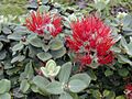
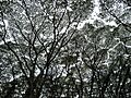
The ʻŌhiʻā lehua tree is very common in Puna.
-
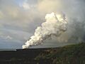
A plume from the Kupaianaha lava flow in Puna near Kalapana.
-
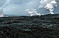
Three lava entries into the ocean in April 2008.
-

Sandalwood trees were plentiful in Puna before the early 1820s.
-
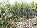
Sugarcane was the main farm product in Puna during the 20th century.
-
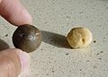
Macadamia nuts, shown here in their shell and roasted, are still a big part of farming in Puna.
-
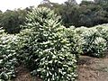
Coffee was the main crop in the 1800s for Puna and has recently returned.
-
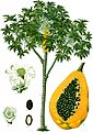
Almost all papayas from Hawaiʻi come from Puna.
-
Albizia trees are a serious invasive plant in Puna, as seen near the "Tree Tunnel" at Lava Tree State Park.
-
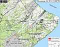
A map showing the path of the June 27th Lava Flow (as of November 24, 2014).
-
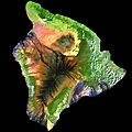
This satellite image shows how most of Puna is covered in green forests, with some visible lava flows.
-
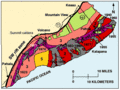
All of the eastern side of Kīlauea is in the Puna District. Lava flows since 1800 are shown in gray. Many homes in Puna are in high-risk lava zones.


