Kaimū, Hawaii facts for kids
|
Kaimu
|
|

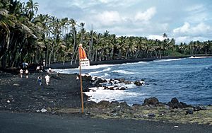
Kaimū Beach, also known as Black Sand Beach, 1959. Beginning in 1983, eruption from the Kīlauea volcano began to affect the area, completely covering it by 1990.
|
|
| Alternative name | Kaimu Beach Park |
|---|---|
| Coordinates | 19°21′30″N 154°58′30″W / 19.35833°N 154.97500°W |
Kaimū was once a small town on the Island of Hawaiʻi. It was located in the Puna District. Sadly, Kaimū was completely covered by hot lava in 1990. This lava came from the Kīlauea volcano.
In the Hawaiian tongue, kai mū means "gathering at the sea." This name likely came from people watching surfers. The lava flow that destroyed Kaimū also covered the nearby town of Kalapana. This powerful flow came from Kīlauea's southeast rift zone.
Kaimū Before the Volcano Changed It
Before 1990, Kaimū was famous for its beautiful black sand beach. This beach was part of Kaimū Bay. Many shady palm trees grew around the bay, making it a popular spot.
Kaimū was also an important place in Hawaiian history. It was the birthplace of Joseph Nāwahī. He was a Hawaiian leader who worked for his people's rights.
What Kaimū Looks Like Now
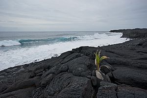
Today, both Kaimū Bay and the town are buried. They lie under about 50 feet (15 meters) of cooled lava. A large part of State Route 130 was also covered. This road is now built on top of the hardened lava. Some new homes have even been built on this new ground.
There is also a "New Beach" that has formed. It has black sand, just like the old beach. Local people and visitors are helping to bring back the lost palm trees. They are planting sprouted coconuts to restore the area.
 | Anna J. Cooper |
 | Mary McLeod Bethune |
 | Lillie Mae Bradford |


