Pahoa, Hawaii facts for kids
Quick facts for kids
Pahoa, Hawaii
Pāhoa
|
|
|---|---|

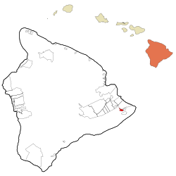
Location in Hawaiʻi County and the state of Hawaii
|
|
| Country | United States |
| State | Hawaii |
| County | Hawaiʻi |
| Settled | early 1900s |
| Area | |
| • Total | 2.18 sq mi (5.64 km2) |
| • Land | 2.18 sq mi (5.64 km2) |
| • Water | 0.00 sq mi (0.00 km2) 0% |
| Elevation | 655 ft (199.6 m) |
| Population
(2020)
|
|
| • Total | 924 |
| • Density | 424.24/sq mi (163.83/km2) |
| Time zone | UTC−10:00 (HST) |
| ZIP code |
96778
|
| Area code(s) | 808 |
| FIPS code | 15-59900 |
| Hawaii does not participate in Daylight Saving Time | |
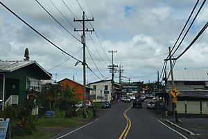
Pāhoa (Hawaiian: Pāhoa) is a small community located in the Puna District of Hawaiʻi County, in the United States. It is on the big island of Hawaii. In 2020, about 924 people lived there. This number was a little lower than in 2010.
Contents
History of Pāhoa
Lava Flow in 2014
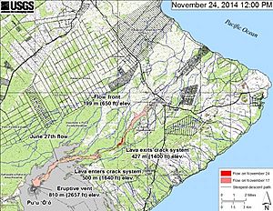
In June 2014, a lava flow started from a volcano vent called Puʻu ʻŌʻō. This lava flow was named the June 27th flow. It moved northeast towards the villages of Kaʻohe Homesteads and Pāhoa.
At first, it looked like the lava would reach Kaʻohe Homesteads. Local leaders and state officials prepared for people to evacuate. The mayor even declared an emergency. However, the lava flow changed direction. It moved away from Kaʻohe Homesteads because of cracks in the ground and a natural valley.
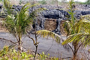
The lava then started moving towards Pāhoa. By October 25, the lava reached the town's recycling center. This center had to close and move. The lava also got close to a cemetery, causing some people to leave their homes. On November 10, one home was destroyed by the lava.
Officials were worried the lava would cover Hawaii Route 130. This road was the only way in and out of Pāhoa and the lower Puna area. To help, the National Park Service planned an emergency route. This route would use part of the old Chain of Craters Road. However, the lava stopped before reaching Route 130. So, the emergency road was not needed.
Volcanic Eruption in 2018
In 2018, another big eruption happened in the lower Puna area. This event caused a lot of lava flows. About 700 homes were lost in nearby Leilani Estates.
Geography and Environment
Pāhoa covers about 2.3 square miles (5.64 square kilometers) of land. The soil in the area comes from volcanic rock. This rock was created by the active Kīlauea Volcano. Kīlauea is one of the most active volcanoes in the world.
The volcanic soils around Pāhoa were formed by lava flows from the last 125 to 500 years. For example, a lava flow in 1840 came within 1.5 miles (2.4 km) of Pāhoa. Two main roads, Hawaii Route 130 and Hawaii Route 132, go through the town.
Population and People
| Historical population | |||
|---|---|---|---|
| Census | Pop. | %± | |
| 2020 | 924 | — | |
| U.S. Decennial Census | |||
In 2010, there were 945 people living in Pāhoa. There were 321 households. The average household had about three people.
The people in Pāhoa come from many different backgrounds. In 2010, about 15% were White, and about 43% were Asian. Around 12.5% were Native Hawaiian or Pacific Islander. Many people were also of two or more races. About 6.5% of the population was Hispanic or Latino.
About 22% of the people were under 18 years old. Around 17% were 65 years or older.
Culture and Meaning
In the Hawaiian language, the word pāhoa means "dagger" or "knife." A statue of a pāhoa pointing downwards is at Pāhoa High and Intermediate School. This statue is a symbol of peace and strength.
We don't know exactly when the first Hawaiians settled here. But the rich soil and old sites suggest people lived here for a long time. Stories about the Pāhoa area are part of ancient Hawaiian history. They are mentioned in the Pele and Hiʻiaka Myth.
Education
Pāhoa has two elementary schools: Pāhoa Elementary School and Keonepoko Elementary School. There are also two secondary schools. These are Pāhoa High and Intermediate School and the Hawaii Academy of Arts and Sciences.
See also
 In Spanish: Pahoa para niños
 | Madam C. J. Walker |
 | Janet Emerson Bashen |
 | Annie Turnbo Malone |
 | Maggie L. Walker |


