
Papaikou, Hawaii facts for kids
Quick facts for kids
Papaikou, Hawaii
Pāpaʻikou
|
|
|---|---|

Location in Hawaii County and the state of Hawaii
|
|
| Country | United States |
| State | Hawaii |
| County | Hawaii |
| Area | |
| • Total | 2.17 sq mi (5.62 km2) |
| • Land | 1.45 sq mi (3.77 km2) |
| • Water | 0.71 sq mi (1.85 km2) |
| Elevation | 236 ft (72 m) |
| Population
(2020)
|
|
| • Total | 1,166 |
| • Density | 801.93/sq mi (309.65/km2) |
| Time zone | UTC-10 (Hawaii-Aleutian) |
| ZIP code |
96781
|
| Area code(s) | 808 |
| FIPS code | 15-61550 |
| GNIS feature ID | 0363121 |
Papaikou (Hawaiian: Pāpaʻikou) is a small community in Hawaii County, Hawaii, United States. It is located just a few miles north of Hilo, which is the main town in the county. In 2020, about 1,166 people lived in Papaikou.
Contents
Where is Papaikou Located?
Papaikou is found on the eastern side of the big island of Hawaii. It sits right by the Pacific Ocean. You can find it at these coordinates: 19°47′38″N 155°5′48″W.
Travel and Area
Hawaii Route 19 goes through Papaikou. This road takes you south about 5 miles (8 km) to Hilo. If you go northwest, it's about 37 miles (60 km) to Honokaa.
The community of Papaikou covers a total area of about 2.17 square miles (5.62 km²). Most of this area is land, but a good part of it, about 0.71 square miles (1.85 km²), is water. The community's coastline stretches from Hokeo Point in the north to Kekiwi Point in the south.
Papaikou's Weather
Papaikou has a tropical rainforest climate. This means it gets a lot of rain all year round. The weather is usually warm and humid.
| Climate data for Papaikou | |||||||||||||
|---|---|---|---|---|---|---|---|---|---|---|---|---|---|
| Month | Jan | Feb | Mar | Apr | May | Jun | Jul | Aug | Sep | Oct | Nov | Dec | Year |
| Mean daily maximum °F (°C) | 77.0 (25.0) |
76.7 (24.8) |
77.2 (25.1) |
77.4 (25.2) |
78.8 (26.0) |
80.4 (26.9) |
81.0 (27.2) |
81.4 (27.4) |
81.8 (27.7) |
81.0 (27.2) |
79.4 (26.3) |
77.7 (25.4) |
79.1 (26.2) |
| Daily mean °F (°C) | 70.0 (21.1) |
69.8 (21.0) |
70.5 (21.4) |
70.9 (21.6) |
72.3 (22.4) |
73.8 (23.2) |
74.6 (23.7) |
75.1 (23.9) |
75.0 (23.9) |
74.4 (23.6) |
73.1 (22.8) |
71.3 (21.8) |
72.6 (22.5) |
| Mean daily minimum °F (°C) | 63.1 (17.3) |
62.9 (17.2) |
63.9 (17.7) |
64.5 (18.1) |
65.8 (18.8) |
67.3 (19.6) |
68.2 (20.1) |
68.8 (20.4) |
68.3 (20.2) |
67.9 (19.9) |
66.8 (19.3) |
64.9 (18.3) |
66.0 (18.9) |
| Average precipitation inches (mm) | 11.21 (285) |
11.20 (284) |
16.01 (407) |
13.88 (353) |
10.00 (254) |
9.33 (237) |
12.14 (308) |
11.54 (293) |
11.64 (296) |
11.35 (288) |
16.79 (426) |
11.29 (287) |
146.38 (3,718) |
People of Papaikou
| Historical population | |||
|---|---|---|---|
| Census | Pop. | %± | |
| 2020 | 1,166 | — | |
| U.S. Decennial Census | |||
In 2020, there were 1,166 people living in Papaikou. This number was a bit lower than in 2010.
Community Life
In 2000, there were 475 households in Papaikou. About 29.5% of these homes had children under 18 living there. Many families were married couples living together. The average household had about 3 people.
The people in Papaikou come from many different backgrounds. In 2000, about 45.83% of the people were Asian, 15.28% were White, and 9.41% were Pacific Islander. Many people also identified as being from two or more races.
Age and Income
The median age in Papaikou in 2000 was 40 years old. This means half the people were younger than 40 and half were older. About 24.2% of the population was under 18.
The average household income in 2000 was about $37,031 per year. The average income for families was a bit higher, around $40,446.
Places to Visit
- Hawaii Tropical Botanical Garden: This is a beautiful garden where you can see many different kinds of plants from tropical areas. It's a great place to explore nature.
Images for kids
-
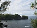
View of Onomea Bay from the scenic route through Papaikou and Pepeekeo, June 2011

See also
 In Spanish: Papaikou para niños
