Paukaa, Hawaii facts for kids
Quick facts for kids
Paukaa, Hawaii
Paukaʻa
|
|
|---|---|

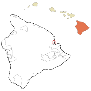
Location in Hawaii County and the state of Hawaii
|
|
| Country | United States |
| State | Hawaii |
| County | Hawaii |
| Area | |
| • Total | 0.43 sq mi (1.11 km2) |
| • Land | 0.33 sq mi (0.85 km2) |
| • Water | 0.10 sq mi (0.26 km2) |
| Elevation | 243 ft (74 m) |
| Population
(2020)
|
|
| • Total | 434 |
| • Density | 1,319.15/sq mi (509.34/km2) |
| Time zone | UTC-10 (Hawaii-Aleutian) |
| Area code(s) | 808 |
| FIPS code | 15-61700 |
| GNIS feature ID | 0363187 |
Paukaʻa (which means Paukaʻa in the Hawaiian language) is a special kind of community in Hawaii County, Hawaii, United States. It's called a census-designated place (CDP). This means it's an area that the government counts for population, but it's not an official city or town.
In 2020, about 434 people lived in Paukaa. Back in 2010, there were 425 people, and in 2000, there were 495. The local ZIP code for Paukaa is 96720.
Contents
Geography of Paukaa
Paukaa is located on the eastern side of the big island of Hawaii. Its exact spot is 19 degrees 45 minutes 59 seconds North and 155 degrees 5 minutes 55 seconds West.
It sits north of a place called Wainaku and south of Papaikou. The larger city of Hilo is about 3 miles (4.8 km) to the south. To the east, Paukaa is right next to the Pacific Ocean, just north of Hilo Bay.
Land and Water Area
The United States Census Bureau says that Paukaa covers a total area of about 1.4 square kilometers (0.54 square miles). Most of this area, about 1.1 square kilometers (0.42 square miles), is land. The rest, about 0.3 square kilometers (0.12 square miles), is water. This means about 19% of Paukaa's total area is water.
Population and People
The number of people living in Paukaa has changed over the years.
| Historical population | |||
|---|---|---|---|
| Census | Pop. | %± | |
| 2020 | 434 | — | |
| U.S. Decennial Census | |||
In the year 2000, there were 495 people living in Paukaa. These people lived in 196 different households, and 137 of these were families. On average, there were about 1,174 people per square mile (453 people per square kilometer). There were also 215 housing units, which are places where people can live.
Who Lives in Paukaa?
In 2000, the people in Paukaa came from different backgrounds:
- About 33.74% were White.
- About 0.40% were African American.
- About 41.41% were Asian.
- About 5.25% were Pacific Islander.
- About 0.40% were from other racial groups.
- About 18.79% were from two or more racial groups.
- About 4.44% of the population were Hispanic or Latino (who can be of any race).
Households and Families
Out of the 196 households in 2000:
- About 23% had children under 18 living with them.
- About 55.6% were married couples living together.
- About 11.7% had a female head of the household with no husband present.
- About 30.1% were not families (meaning individuals living alone or with non-relatives).
- About 26.5% of all households were made up of just one person.
- About 20.9% had someone living alone who was 65 years old or older.
The average household had about 2.53 people, and the average family had about 2.94 people.
Age Groups
In 2000, the population of Paukaa was spread out by age:
- About 17.6% were under 18 years old.
- About 5.7% were between 18 and 24 years old.
- About 19.6% were between 25 and 44 years old.
- About 30.1% were between 45 and 64 years old.
- About 27.1% were 65 years old or older.
The average age of people in Paukaa was 50 years old. For every 100 females, there were about 88.9 males.
See also
 In Spanish: Paukaa para niños
 | Mary Eliza Mahoney |
 | Susie King Taylor |
 | Ida Gray |
 | Eliza Ann Grier |

