Lake Superior Lowland facts for kids
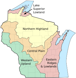
The Lake Superior Lowland, also known as the Superior Coastal Plain, is a special area in northern Wisconsin, a state in the U.S.. It's right next to Lake Superior. This lowland stretches for about 1,250 square miles (3,200 square kilometers). It doesn't go more than 20 miles (32 kilometers) away from the lake's shore.
Contents
About the Lake Superior Lowland
This area is mostly a flat plain that gently slopes down towards Lake Superior. Even though it's mostly flat, the land's height changes. It can be from about 600 feet (180 meters) to 1,000 feet (300 meters) above sea level. The highest parts are on the Bayfield Peninsula. Here, the flat land turns into more rugged hills.
Natural Wonders and Features
Northeast of the Bayfield Peninsula are the Apostle Islands. These islands are a special place protected as a National Lakeshore. This means they are kept safe for everyone to enjoy their natural beauty.
Most of the Lake Superior Lowland is covered by forests. Many of these forests have aspen and birch trees. You can also find some conifer trees mixed in. Some parts of the plain are used for farming, like growing crops or raising animals. There are also some wet areas, like marshes and wetlands. Several rivers flow through this region and empty into Lake Superior. One important river is the Brule River, which is surrounded by a State Forest.
People and Communities
Two Ojibwa Indian reservations are located along the shores of Lake Superior. These are the Bad River Indian Reservation and the Red Cliff Indian Reservation. The biggest city in this area is Superior, Wisconsin. Other towns include Ashland and Washburn. People often call this northern Wisconsin area "up north."
Counties in the Lake Superior Lowland
Parts of these counties are found within the Lake Superior Coastal Plain:
 | Jessica Watkins |
 | Robert Henry Lawrence Jr. |
 | Mae Jemison |
 | Sian Proctor |
 | Guion Bluford |


