
Mission Hill, Boston facts for kids
Quick facts for kids |
|
|
Mission Hill Triangle Historic District
|
|

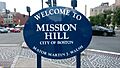
Welcome sign in Brigham Circle intersection, Mission Hill, Boston, near front of Stoneman Plaza, Brigham and Women’s Hospital (BWH)
|
|
| Location | Boston, MA |
|---|---|
| Area | 02120 |
| Architect | Multiple |
| Architectural style | Colonial Revival, Late Victorian |
| NRHP reference No. | 89001747 |
| Added to NRHP | November 6, 1989 |
Mission Hill is a neighborhood in Boston, Massachusetts. It's about three-quarters of a square mile (2 square kilometers) and is mostly a place where people live. It's next to other Boston neighborhoods like Roxbury, Jamaica Plain, and Fenway-Kenmore, and also borders the town of Brookline.
The neighborhood has two main streets, Tremont Street and Huntington Avenue. You can get around Mission Hill using the MBTA's Green Line E branch and the Orange Line at Roxbury Crossing station.
Mission Hill is home to several important places like Brigham and Women's Hospital and New England Baptist Hospital. Even though people first settled here in the 1600s, the area is famous for its brick row houses and "triple-decker" homes built in the late 1800s. It also has community centers, a branch of the Boston Public Library, a high school, and a local newspaper. In 2011, about 15,883 people lived in Mission Hill.
Contents
Exploring Mission Hill's Location and Features
Mission Hill has two main streets for shopping and eating: Tremont Street and Huntington Avenue. Both streets have many small restaurants and shops. Mission Hill is at the far western end of Tremont Street. The main ZIP Code for Mission Hill is 02120. Some small parts of the neighborhood use other ZIP Codes like 02130, 02115, and 02215.
Areas like Parker Hill, Back of The Hill, and Calumet Square are all part of the official Mission Hill neighborhood in Boston. You'll see signs that say "no parking" without a special sticker for residents.
What is Brigham Circle?
Brigham Circle is at the corner of Tremont and Huntington. It's the main center for businesses in the neighborhood. Here you'll find a grocery store, drug stores, cafes, banks, and places to eat. Just one block up the hill from Brigham Circle is Kevin W. Fitzgerald Park. This park was created in 2002 when a new building was finished.
Famous Buildings and Parks in Mission Hill
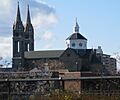
On Tremont Street, you'll see the Our Lady of Perpetual Help Basilica. It was built in 1878, with its tall towers added in 1910. This church is a landmark that stands out in the area's skyline. It's often called "Mission Church."

Close by is the Parker Hill Library, which is the local branch of the Boston Public Library. It was designed by architect Ralph Adams Cram in 1929 and has been recently restored. The city used a process called eminent domain to get the land for both the library and the nearby Mission Hill playground.
At the very top of the hill, you'll find the New England Baptist Hospital and the Parker Hill Playground. This playground stretches from the hospital grounds down Parker Hill Avenue.
Where is Mission Hill Located?
The Mission Hill neighborhood is generally bordered by Columbus Avenue and the Roxbury neighborhood to the east. To the northeast, it's bordered by Ruggles Street. To the west, it's next to the Olmsted-designed Riverway/Jamaicaway and the town of Brookline.
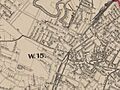
The Mission Hill Historic District was recognized by the Boston Landmarks Commission in 1985. This district is roughly bordered by Smith Street, Worthington Street, Tremont Street (to the south), and Huntington Avenue (to the west). Mission Hill is just north of the Jamaica Plain neighborhood.
You can easily reach Mission Hill by the MBTA Green Line E branch and the Orange Line. It's also close enough to walk to the Museum of Fine Arts and the Gardner Museum.
"The Hill" also includes about half of the Longwood Medical and Academic Area. This area has 21 health care, research, and education places. It's the biggest employment area in Boston outside of downtown Boston. Because of all these institutions, the neighborhood sometimes faces challenges as these places grow and use up residential buildings or commercial spaces. However, new shops, restaurants, and homes have given the neighborhood a stronger voice. Some schools have also promised to house their students in new dorms. About 32% of the people living in Mission Hill are between 20 and 24 years old.
The Mission Hill Triangle is a special area known for its architecture. It has old houses built by rich landowners, traditional brick rowhouses, and many "triple-deckers." Many of these homes are now condominiums, but some are still two-family or single-family homes.
In March 2008, The Boston Globe newspaper named Mission Hill one of the "25 Best ZIP Codes in Massachusetts." They noted that single-family homes had increased in value, there were many restaurants and shops, and the neighborhood was very diverse. They also mentioned that 65% of residents walk, bike, or use public transit to get to work.
Green Spaces and Parks in Mission Hill
Mission Hill has a few large parks where you can walk or relax.
- Kevin W. Fitzgerald Park was once called Puddingstone Park because of the local rock found there. The park has grassy areas and paved paths for walking. Benches line the paths, offering views of Lower Roxbury, the Fenway, and Back Bay. This park used to be one of Boston's five quarries, known as the Harvard Quarry. The quarry stopped operating around 1910, leaving a 65-foot-high rock wall. In the 1990s, the community worked to protect public access to the quarry. They decided to keep the old quarry walls and create a new 6-acre park for the community. In 2006, it was renamed Kevin Fitzgerald Park to honor a former Massachusetts State Representative. Most of the land around it is being developed for housing and other buildings, but 6.2 acres are protected for public use.
- McLaughlin Park is another park in Mission Hill. In April, the Mission Hill Gazette newspaper reported that the park was being renovated with a $430,000 budget. The plans include a loop path, an overlook area, repairs to "Ben's Tower," and new stairs. Ben's Tower is a memorial for a child named Ben from Mission Hill who loved playing in the park and sadly passed away from cancer.
- The Butterfly Garden is a smaller, lovely gated garden located in the Back of The Hill area.
How Mission Hill Looks and Feels
The Mission Hill Main Streets group works to keep the main streets where businesses are located looking neat and improved. Business owners can get help with advice and even money for things like new awnings or building repairs.
The Community Alliance of Mission Hill (CAMH) is a group of neighbors, mostly property owners, who watch out for new developments and building requests in Mission Hill. The Mission Hill Beautification Task Force (MHB Task Force) is a part of CAMH. They focus on cleaning up, preserving, and making the neighborhood look better. They also educate people about well-being and the quality of life in Mission Hill.
MBTA Subway Stops in Mission Hill
- On the Green Line E branch:
- Longwood Medical Area
- Brigham Circle
- Fenwood Road
- Mission Park
- Riverway
- Back of the Hill
- On the Orange Line:
- Roxbury Crossing
The neighborhood also has MBTA bus routes. Route 39 goes from Forest Hills in Jamaica Plain to Back Bay Station. Route 66 goes from Dudley Square through Brookline to Harvard Square in Cambridge.
Who Lives in Mission Hill?
In 2011, about 15,883 people lived in Mission Hill. The population is very diverse:
- 47.8% White
- 18.0% Black or African American
- 17.5% Hispanic or Latino
- 14.1% Asian
- 1.2% "two or more races"
- 1.4% "other"
Because many colleges and universities are nearby, and because there are several dorms, a lot of people living in Mission Hill are in their early to mid-20s. The American Community Survey estimated that people between 20 and 24 years old make up most of the population.
| Age | Percent | Age | Percent |
|---|---|---|---|
| Under 5 years | 3.1% | 45 to 49 years | 3.9% |
| 5 to 9 years | 3.2% | 50 to 54 years | 2.7% |
| 10 to 14 years | 4.3% | 55 to 59 years | 3.1% |
| 15 to 17 years | 2.2% | 60 to 64 years | 3.2% |
| 18 and 19 years | 7.9% | 65 to 69 years | 1.8% |
| 20 to 24 years | 32.3% | 70 to 74 years | 2.9% |
| 25 to 29 years | 9.4% | 75 to 79 years | 2.0% |
| 30 to 34 years | 6.0% | 80 to 84 years | 1.4% |
| 35 to 39 years | 4.4% | 85 years and over | 2.4% |
| 40 to 44 years | 3.9% |
In 2011, the average household income in Mission Hill was $33,432 per year. About 21.1% of households made less than $10,000 yearly. The average family income was $36,237. The highest percentage of families (12.0%) made between $75,000 and $99,999 yearly. Out of 6,230 households, 1,300 received food stamps (SNAP) over a 12-month period.
Mission Hill's Past: A Brief History
Industry started in the Mission Hill area as early as the 1600s.
A documentary video called Mission Hill and the Miracle of Boston (1978) tells much of the early history of Mission Hill up to 1978. It explains how the Urban Renewal Program in Boston affected Mission Hill.
Early Days: 17th and 18th Centuries
Mission Hill was once part of Roxbury before Roxbury became part of Boston. Old maps show it was often called Parker Hill. Over time, especially recently, it became known as its own separate neighborhood. Most government and business groups now recognize "Mission Hill" as a distinct Boston neighborhood with agreed-upon borders.
Before the American Revolution, Mission Hill had large country estates owned by rich Boston families. Much of the area was an orchard farm, first owned by the Parker family in the 1700s. The story goes that Peter Parker died when a barrel of his own cider fell on him! An annual "cider press" event is held in the park at the top of the hill, near New England Baptist Hospital, to remember this story.
The orchard continued for some time, but slowly parts of the land were sold and developed. Boston's reservoir used to be at the top of the hill. Many old apple trees along Fisher Avenue and in an undeveloped part of the playground are probably from the Parker family's original trees. The lower eastern part of the hill was a puddingstone quarry.

Maps show that Mission Hill started developing before the Fenway and Longwood Medical Area. Huntington Avenue, which is now a main road to the rest of Boston, used to stop at Parker Street. Mission Hill was connected to the Back Bay by Parker Street, which was a raised path between the Stony Brook and the Muddy River. Today, part of Parker Street is called Hemenway Street. Many other streets leading into Mission Hill were changed or renamed at Huntington Avenue, making it harder for people and cars to get through.
Growth in the 19th Century
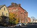
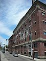
The first brewery was built at the foot of Parker Hill in the 1820s. By the 1870s, making beer was the main industry in Mission Hill. Many breweries were along the Stony Brook. Most of Boston's breweries were once in Mission Hill. However, three periods of Prohibition (when alcohol was banned) and the rise of big national beer brands caused many breweries to close. Many of the old brewery buildings are now being turned into condominiums.
After the 1880s, and after Frederick Law Olmsted changed the path of the Muddy River, Huntington Avenue was extended to Brigham Circle. This created the Triangle District.

Building in Mission Hill really picked up in the mid-1800s. In 1870, the Redemptorist Fathers built a small wooden church. This was replaced by a large Roxbury puddingstone church in 1876. In 1910, two tall spires were added, which you can still see dominating the skyline today. In 1954, Pope Pius XII made the church a basilica, which is a special church. It's officially called Our Lady of Perpetual Help but everyone calls it "Mission Church." Because of the way the church was built on a slope, one spire is 215 feet tall, and the other is two feet shorter. The church is also 215 feet long, making it perfectly proportioned.
The Basilica used to be a group of buildings, including a convent and a grammar school. The church closed Mission Church High School in 1992, but an elementary school is still there. Selling these buildings helped restore much of the church. The sold buildings are now planned to become "Basilica Court," a residential complex with 229 apartments.
Another beautiful religious building is the Annunciation Greek Orthodox Cathedral of New England at 514 Parker Street. It's considered the "mother church" for the Greek Orthodox Church in New England. Built between 1892 and 1927, it's one of the oldest Greek churches in the United States. It's a Boston landmark and is listed on the National Register of Historic Places.
Puddingstone rock is important to the area's history. The large puddingstone quarry between Tremont Street and Allegany Street provided the stone for the foundations of most of the houses built in the late 1800s. This local stone made it quick to build homes for working-class families. Some buildings around the Tremont Street/Parker Street intersection are made entirely of this stone.
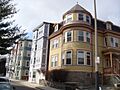
Most houses in the neighborhood have stone foundations and wood construction. However, the Triangle Historic District along Huntington Avenue has stone and brick buildings. This is one of only eight such districts in Boston to be given landmark status. These 71 buildings, bordered by Huntington Avenue, Tremont Street, and Worthington Street, show how the neighborhood developed from the 1870s to the 1910s.
By 1894, electric streetcars were running on Huntington Avenue. Builders started creating streets through the farmland on the hillside and building homes for people who commuted to work. An example is the Timothy Hoxie House at 135 Hillside Street. It's a freestanding Italianate villa built in 1854. The Hoxie family moved from Beacon Hill to the more rural Mission Hill. Large Single-family houses like this are rare in the area today. As the demand for housing grew, builders started constructing multi-family homes on smaller lots.
By the 1890s, Mission Hill felt more like a city, and the hill was covered in "triple-deckers." Streets with Native American names like Calumet and Iroquois were quickly built up into a dense neighborhood of triple-deckers in the Queen Anne style. This style is very common in Mission Hill because it was popular when most of these homes were built.

Before 1900, the Georgian Revival New England Baptist Hospital was one of the few large institutions in the neighborhood. Other institutions soon followed, moving from downtown Boston to Mission Hill/Longwood for more space and cheaper land. In 1906, the Harvard Medical School moved into five buildings on Longwood Avenue. Wentworth Institute of Technology started building in 1911. In 1912, the Peter Bent Brigham Hospital (now Brigham & Women's Hospital) opened. In 1914, Children's Hospital also moved to Longwood Avenue.
Mission Hill in the 20th Century
From the late 1800s through the 1970s, Mission Hill was home to many immigrant families, mostly Irish, but also Germans, Italians, and others. After the 1950s, many people left the neighborhood due to urban renewal projects and people moving to the suburbs.
In the early 1960s, the Boston Redevelopment Authority tore down several homes in the Triangle District to build the Whitney Redevelopment Project. This project included three tall apartment buildings: Charlesbank Apartments, Back Bay Manor (now CityView at Longwood), and Franklin Square Apartments (now The Longwood). This was one of Boston's first redevelopment projects not funded by the federal government. Across the street is Mission Main, one of the oldest public housing developments in the country. The original brick buildings from 1938-1940 were torn down in the mid-1990s and replaced with 535 new apartments.

Many breweries were once in Mission Hill, including A.J. Houghton, American Brewing Co. (now American Brewery Lofts), and Alley Brewing Co.

In the late 1960s, Harvard University secretly bought many homes in the neighborhood and planned to tear them down. Most were replaced with the Mission Park residential complex in 1978, after local residents organized to convince Harvard to rebuild. The complex sits where a large orphanage called the House of the Good Shepard once stood.

Also in the 1960s, the government planned to extend Interstate 95 into Boston. They started buying property and tearing down houses. This area, once known as Pierpoint Village, was a busy commercial area with a theater and shops.
The Interstate project was stopped in 1971. Ten years later, the Southwest Corridor was created. This is a park system with bike and walking trails that lead into downtown Boston.
By the early 1970s, Mission Hill was seen as a dangerous area, and many people moved away. With low property values, many homes were bought by landlords and turned into rentals. The cheap rents attracted many students from nearby colleges like MassArt, Northeastern University, Wentworth Institute of Technology, and the School of the Museum of Fine Arts. The Mission Hill Artists Collective now holds "Open Studios" every fall.
As fears faded by the mid-1990s, the area began to change. Homeowners moved into newly converted condominiums to enjoy the great city views and be close to the Longwood Area, the MBTA, and downtown Boston.
Mission Hill Today: 21st Century Changes
Today, Mission Hill is becoming more developed and diverse. It has new luxury condominiums and lofts, triple-deckers turned into condos, student rentals, newly rebuilt public housing, and many long-time residents. It's one of the most diverse neighborhoods in Boston, with people of white, Indian, Asian, Hispanic, and African-American backgrounds living together peacefully.
Things to Do and See in Mission Hill
Community Groups and Centers
- The Tobin Community Center is at 1481 Tremont Street. It's a place for social, educational, and fun activities for children, teens, adults, and families in Mission Hill and nearby areas. It's open seven days a week, and most programs are free, though you need a free membership to join.
- Mission Hill Main Streets (MHMS) is a non-profit group that helps local businesses, residents, and community organizations. They support businesses with advice and financial help for things like storefront renovations. They also work to improve the look, health, and safety of the business areas.
- The Parker Hill Branch Library of the Boston Public Library is open Monday through Saturday. It offers children's programs all year, often working with the Tobin Community Center and other local groups. It also displays art by local artists.
- The Mission Hill Health Movement (MHHM) works "For a Healthier Hill." They've been helping the community since 1970. They helped create the Fenway Community Health Center and offered the first free flu shots for older people in the neighborhood. They also helped start a dental care program for children.
- Current MHHM Programs include: Seasonal Farmers Markets at Roxbury Crossing and Brigham Circle; the Gore St Community Garden; a Mission Hill Noise Study; Mission Hill Walks! (a Walking Group); and an Annual Mission Hill Health and Wellness Fair.
- Sheehy Park is located between the Parker Hill Branch Library and Mission Church. Young people play here, the annual Mission Hill Health, Wellness, and Fitness Fair is held here in the fall, and students gather to chat and study.
Healthcare in Mission Hill
World-class teaching hospitals are found in the nearby Longwood Medical Area. Some of their buildings are even within the residential part of Mission Hill.
Brigham and Women's Hospital has a community relations team that helps the Mission Hill community. They work on health care, jobs, and social programs by reaching out to schools, housing developments, and other groups.
Residents can also get medical care at local health centers like the Whittier Street Health Center.
The Mission Hill Health Movement is a community group that helps with many health issues for residents, such as obesity, diabetes, heart disease, and mental health. They also help people get access to health care. They sponsor twice-weekly Mission Hill Farmers markets from June to November, an annual community health fair, and a low-cost fresh produce program. At the farmers' markets, local farmers sell fresh produce. MHHM also sponsors self-help health programs like a walking group and a Diabetes Self-Management Group.
In 2011, several groups sponsored the first Mission Hill healthy food festival. Hospitals, schools, and health centers provided information. Each spring, the Mission Hill Health Movement hosts a community health fair with many local groups offering health information and screenings. They also lead "FEET FIRST" walks on Thursdays, exploring the neighborhood and nearby areas.
Green Energy Efforts
Some developers, architects, and contractors have shared plans with the Community Alliance of Mission Hill for building projects that use very little or no carbon, or are designed to be very energy efficient.
Education in Mission Hill
Fenway High School is a public pilot school in Boston, located at 67 Alleghany St. It's known nationally for being innovative and excellent. Students and teachers learn together in a diverse and respectful community.
Fenway High School was founded in 1983 and became one of Boston's first six pilot schools in 1994. It aims to provide a high-quality, personalized education to students from all over Boston. There are no academic requirements to get in. The school is based on three main ideas:
- Challenging students intellectually
- Building personal relationships
- Working with outside organizations
The school's goal is to create a community of learners who care about society and are responsible. They value each student and want to encourage academic excellence, good thinking habits, self-esteem, and leadership skills in everyone.
| Educational attainment, ages 25+ | Total | % | Male | % | Female | % |
|---|---|---|---|---|---|---|
| Total population | 7,441 | 100% | 3,360 | 100% | 4,081 | 100% |
| Less than high school diploma | 1,240 | 16.7% | 455 | 13.5% | 785 | 19.2% |
| High school graduate/GED/equivalent | 1,787 | 24.0% | 726 | 21.6% | 1,061 | 26.0% |
| Some college | 1,126 | 15.1% | 569 | 16.9% | 557 | 13.6% |
| Associate degree | 418 | 5.6% | 171 | 5.1% | 247 | 6.1% |
| Bachelor's degree or higher | 2,870 | 38.6% | 1,439 | 42.8% | 1,431 | 35.1% |
| Source: | ||||||
The table above shows estimates from the American Community Survey between 2007 and 2011.
In the nearby Longwood Medical Area, you'll find the Harvard Medical School, Harvard School of Public Health, Harvard School of Dental Medicine, Massachusetts College of Pharmacy and Health Sciences, and programs run by Harvard's teaching hospitals. Also close to Mission Hill/Longwood are the Colleges of the Fenway, Wentworth Institute, Northeastern University, and the School of the Museum of Fine Arts.
Local Newspapers
- Mission Hill Gazette
Neighborhood Groups
- Alice Heyward Taylor Tenant Task Force
- Boston Redevelopment Authority neighborhood site
- Community Alliance of Mission Hill – The Mission Hill Beautification Task Force is a subgroup that works to keep the neighborhood clean and promote green living.
- Mission Hill Artists Collective –
- Mission Hill Health Movement – They run farmers' markets, offer low-cost fresh produce, and host an annual community health fair.
- Mission Hill Main Streets –
- Mission Hill Neighborhood Housing Services – This group manages many multi-unit properties in Mission Hill.
- Mission Main Tenant Task Force, Smith Street
- Roxbury Tenants of Harvard
- Sociedad Latina, Tremont Street
- Mission Hill Arts Festival
Images for kids
-
Welcome sign in Brigham Circle intersection, Mission Hill, Boston, near front of Stoneman Plaza, Brigham and Women’s Hospital (BWH)
-
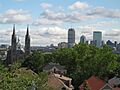
View of Mission Church and Boston skyline from near top of Mission Hill
-
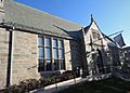
Parker Hill Branch, BPL
-
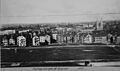
View from top of Parker Hill, 1910
-
Mission Church
-
Row Houses Along Parker Street
-
Former Alley Brewing Company building at 117 Heath Street.
-
The former Oliver Ditson Company building and later Pickle Factory building, 2007
-
1874 Map of Roxbury Crossing

