
Muddy River (Massachusetts) facts for kids


The Muddy River is a series of small brooks and ponds. It flows through parts of Boston, Massachusetts. This includes areas of the city's famous Emerald Necklace park system. It also runs along the southern edge of Brookline, Massachusetts. Brookline was even called Muddy River Hamlet before it became a town in 1705!
The Muddy River is narrower than most waterways called "rivers" in the United States. It is a protected public area for fun and relaxation. Parks and hiking trails surround it. The Massachusetts Department of Conservation and Recreation helps manage it.
The river starts at Jamaica Pond. It then flows through Wards Pond, Willow Pond, and Leverett Pond in Olmsted Park. Next, it goes under Route 9 through a hidden tunnel. It then enters a narrow park called the Riverway. From there, it flows through three more tunnels. These are the Riverway Culvert, the Brookline Avenue Culvert, and the Avenue Louis Pasteur Culvert. The Muddy River continues from the Fens area. It connects to the Charles River near Charlesgate. This part of the river flows through a stone-paved channel. It is surrounded by narrow parklands. The river passes under several bridges and tunnels. These include Boylston Street, the Massachusetts Turnpike, Commonwealth Avenue, Storrow Drive, and the Bowker Overpass.
River's Past
In its natural state, the Muddy River was much wider. It flowed into the Charles River, which was affected by ocean tides. The river formed the eastern border of Brookline with Boston and Roxbury. This was true from Brookline's start in 1705 until 1873. That's when Boston took over the Allston–Brighton area.
The river and its surrounding parks look the way they do today because of the Emerald Necklace project. This big project happened between 1880 and 1900. A famous designer named Frederick Law Olmsted led the work. They changed marshy land into beautiful sculpted riverbanks. They also planted many trees and plants.
The Muddy River is even mentioned in an old journal! John Winthrop wrote about it in his "Journal of John Winthrop." In March 1638 or 1639, a witness named James Everell told him about a strange flying object seen near the river. Some people think this might be the first recorded sighting of an unidentified flying object!
Restoring the River
A group called The Maintenance and Management Oversight Committee (MMOC) is working to restore the Muddy River. This group is made up of citizens. They watch over the Muddy River Restoration Project. The original plan for this project came from Boston's Parks and Recreation Department. Other groups, like the Commonwealth of Massachusetts and the Federal Emergency Management Agency, also helped. The United States Army Corps of Engineers was allowed to study the river. This was thanks to a law called the Water Resources Development Act of 1996.
Phase 1 of the project had several goals. It aimed to create new river crossings. It also cleared things that blocked sunlight from reaching the river. Workers also replanted the river's edge. This made the area more beautiful and helped create homes for local wildlife. Phase 1 finished successfully in 2016. Over 230 trees were planted. Also, parts of the river that were covered were opened up to sunlight. This is called daylighting.
Margaret Dyson, who works for Boston Parks and Recreation, explained Phase 2. This phase is about dredging the river. Dredging means removing mud and dirt from the bottom. This helps reduce damage from flooding. It also involves more work in the river itself.
However, Phase 2 has faced some challenges. In 2018, a large concrete wall was planned to help with flooding. The Boston Landmarks Commission did not like this idea. They didn't want a big concrete wall next to the river. They approved the rest of the plan. But they asked the Parks Department to come back with a better idea for the wall. The project was expected to continue construction in 2020.
Images for kids
-
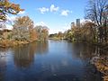
The Muddy River in the Back Bay Fens
-
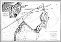
Olmsted's 1887 plan for the Back Bay Fens
-
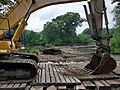
Restoration work in 2021


