
Haymarket Square (Boston) facts for kids

Haymarket Square is the historic name of a former town square in Boston. It was located where several important parts of Boston meet, including the North End, Government Center, the Bulfinch Triangle, and the West End. This square was a well-known spot in Boston from the mid-1800s to the mid-1900s.
The buildings around Haymarket Square were later taken down. This made way for a big highway called the Central Artery and the area known as Government Center. Even though the original square is gone, the Haymarket produce market still operates very close to where the historic square used to be.
Contents
How Haymarket Square Was Created
Long ago, when Europeans first settled in Boston, the area that would become Haymarket Square was part of Boston Harbor. It was a small bay called Mill Cove. In the 1640s, a dam was built across the mouth of the cove. This turned it into a pond known as Mill Pond.
In 1807, the town of Boston allowed a company to start filling in Mill Pond. A famous architect named Charles Bulfinch suggested a street plan for this new land in 1808. The filling of the pond to create the area called the Bulfinch Triangle was finished in the early 1820s. The spot where Haymarket Square would be, where Merrimack, Canal, and Charleston Streets met, appeared on a map in 1826.

An old drawing from 1895, titled "View of the New Land in 1828," shows Haymarket Square. Other pictures from the early 1800s show farmers selling hay in the square. The name "Haymarket Square" officially appeared on a map in 1844.
Railroads and Subways in Haymarket Square
From 1845 until 1897, the most important building in the square was the Boston and Maine Railroad depot. This was a train station. In 1893, a new, larger station called North Union Station was built a few blocks north. The old depot was then torn down.
The demolition made room for the Canal Street incline. This was the northern end of the Tremont Street subway, which was the first part of what is now the MBTA Green Line. The Haymarket subway station opened in 1898. It had a small building, like a kiosk, in the middle of Haymarket Square for people to enter. In 1902, the Haymarket Relief Station opened. This was a branch of Boston City Hospital, built on the old train depot site.
Changes to the Square Over Time
Most of the buildings around Haymarket Square were torn down in the 1950s. This was to build the elevated Central Artery highway. More buildings were removed in the 1960s for the construction of Government Center.
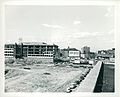
In January 2017, construction began on Bulfinch Crossing. This is a huge new development on the site of the Government Center Garage. The northeast corner of this garage is exactly where Haymarket Square used to be.
The Name "Haymarket" in Boston Today
The name "Haymarket" has been used for different places in Boston over time:
- The Haymarket Theatre was a building that operated on the other side of Boston Common. This was many decades before Haymarket Square was even created.
- The Haymarket Station is a stop on Boston's Orange and Green subway lines. It is located right next to where the historic square once stood.
- The Haymarket produce market is a famous outdoor market. It is run by the Haymarket Pushcart Association and continues to sell fresh produce near the old square.
- "Haymarket Square" was also the first name for a hotel and market building. Construction started in 2018 on Blackstone Street, just a block south of the historic square. By 2020, the hotel was planned to be called the "Canopy Hotel Parcel 9."
Images for kids
-
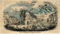
1853 "View of Haymarket Square"
-

A map of Boston from 1645
-
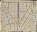
A map from 1743
-
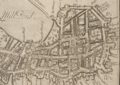
A plan for filling in the Bulfinch Triangle from 1807. Haymarket Square is at the bottom center.
-
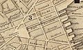
An 1844 map, showing the first use of the name "Haymarket Square"
-
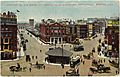
A view from 1909. The small building is an entrance to the Haymarket subway station. The Haymarket Relief Station is in the back.
-
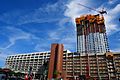
Bulfinch Crossing being built in 2019
-
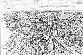
A 1955 drawing by Jack Frost. Haymarket Square is in the middle, with the new Central Artery highway on the right.
-
A view looking north in the 1960s. The land on the left was cleared for Government Center.
-
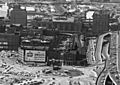
The JFK Federal Building being built in the 1960s. Haymarket Square and the Haymarket Relief Station are on the right.
-
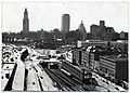
A view from the late 1960s. The elevated Central Artery is on the left. What's left of Haymarket Square is the traffic circle in the center.
-
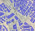
An approximate map showing 2006 buildings over an 1881 map. No 1881 buildings remain.


.jpg)


