
Government Center, Boston facts for kids

Government Center is a special area in downtown Boston. It's like the city's main office, where many important government buildings are located. This area is built around City Hall Plaza. Before it became Government Center, this spot was a lively place called Scollay Square. Today, you'll find Boston City Hall, courthouses, and other state and federal offices here. It's also home to a big MBTA subway station.
Contents
Important Buildings in Government Center
Boston City Hall

The biggest building in Government Center is the huge Boston City Hall. It was built in the 1960s. Its style is called "brutalist," which means it uses a lot of concrete and has a very strong, blocky look. Some people think it's an interesting building, but many locals don't like it. They also remember that it replaced the older, more decorative buildings of Scollay Square, which used to be a busy shopping area.
John Fitzgerald Kennedy Federal Building
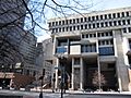
The John Fitzgerald Kennedy Federal Building is a United States government office building. It stands across City Hall Plaza from Boston City Hall. This building also shows the modern style of the 1960s. It has two tall towers, each 26 floors high (about 118 meters or 387 feet). A shorter, four-story building connects the two towers with a glass walkway.
City Hall Plaza

City Hall Plaza is the large open space in the middle of Government Center. It's made mostly of concrete and brick. Many people don't find it a very welcoming place. It has very few benches or green plants. Because of this, even on nice days, it can feel empty. People sometimes call it "the brick desert." The plaza covers about 11 acres (4.5 hectares).
Government Service Center

Another very large building in the brutalist style is the Government Service Center. It's not as well-known as City Hall because it's in a less central spot. The building was designed by architect Paul Rudolph. It was never fully finished, as a tall central tower that was planned was never built. In the 1990s, the Edward W. Brooke Courthouse was built next to it. This courthouse holds a part of the Boston Municipal Court. Even though it's incomplete, some people praise its "wondrous interior courtyard."
Government Center Garage
This large parking garage has space for 2,300 cars. It was built as part of the original Government Center project. In 2016, plans were approved to replace the garage with a new project called "Bulfinch Crossing." This new development will include offices, shops, and homes. Construction on Bulfinch Crossing started in 2017.
Center Plaza

Center Plaza is a big building with offices and shops. It's located across Cambridge Street from City Hall Plaza. In 2014, the building was sold. The new owners planned a $25 million renovation to make the building more exciting. These plans were approved in 2016.
Nearby Public Buildings
Several other important government buildings are located close to Government Center. These buildings were not built as part of the Government Center project itself. They include the Massachusetts State House, the McCormack Building, the Saltonstall Building, the Suffolk County Courthouse, and the Thomas P. O'Neill Jr. Federal Building. Some maps and sources consider these buildings to be part of the Government Center area.
Location and Getting Around
Boundaries of Government Center
Government Center doesn't have official borders. Different maps and documents show slightly different areas for it. For example, the Boston Redevelopment Authority map shows most of Government Center as part of the Downtown neighborhood. The rest is shown as part of the West End. Other maps, like the Boston Zoning Code map, show a larger area that includes the Massachusetts State House. Google Maps shows an even smaller area.
Mass Transit

The subway station in this area has a long history. The first station, called Scollay Square station, opened in 1898. It was rebuilt in 1963 and renamed Government Center station. It was rebuilt again from 2014 to 2016, and now has a large glass entrance on City Hall Plaza. This station is a very important spot for the MBTA subway system. It's where you can switch between the Blue and Green Lines.
Surroundings
Government Center is located between the North End and Beacon Hill neighborhoods. It's very close to historic places like Faneuil Hall and the popular Quincy Market. The Old State House is also nearby. Two blocks away is the Rose Fitzgerald Kennedy Greenway, a park created after the "Big Dig" project. Some of the main streets in the area include Tremont, Congress, Cambridge, State, New Chardon, and Washington Streets. You can still see hints of an old street called Cornhill along one side of City Hall Plaza. Two old buildings, the Sears' Crescent and Sears' Block, face the plaza and follow Cornhill's original curve.
Government Center in Pop Culture
- The Boston band The Modern Lovers recorded a song called "Government Center." In the song, singer Jonathan Richman sings about rocking out at Government Center to make the secretaries feel better.
- The ska/punk band Jaya The Cat also has a song called "Government Center."
- The rock band Brand New included a song called "Logan to Government Center" on their first album.
- The Government Service Center building was used as the headquarters for the Massachusetts State Police in the 2006 movie The Departed.
- Government Center appears in several scenes of the 1973 movie The Friends of Eddie Coyle.
Images for kids
-
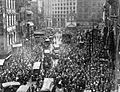
Militia tries to maintain order in Scollay Square during the 1919 Boston Police Strike.
-
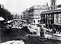
Scollay Square in the 1880s
-
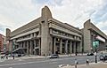
Boston Government Service Center
-
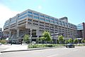
Government Center Garage
-
Boston City Hall
-
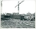
City Hall under construction in the 1960s
-
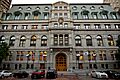
Suffolk County Courthouse
-
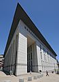
Edward W. Brooke Courthouse
-
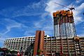
Government Center Garage during its redevelopment as Bulfinch Crossing, 2019


.JPG)


