
Winthrop, Massachusetts facts for kids
Quick facts for kids
Winthrop, Massachusetts
|
|||
|---|---|---|---|
|
Town, de facto City
|
|||

Aerial view of Winthrop and Boston, Massachusetts skyscrapers
|
|||
|
|||
| Nickname(s):
Winthrop-by-the-Sea
|
|||
| Motto(s):
"Where the North Shore begins"
|
|||

Location in Suffolk County and the state of Massachusetts
|
|||

Winthrop, Massachusetts
Location in the United States
|
|||
| Country | United States | ||
| State | Massachusetts | ||
| County | Suffolk | ||
| Settled | 1630 | ||
| Incorporated | 1852 | ||
| Government | |||
| • Type | Council-manager | ||
| Area | |||
| • Total | 8.32 sq mi (21.55 km2) | ||
| • Land | 1.6 sq mi (5.16 km2) | ||
| • Water | 6.33 sq mi (16.39 km2) | ||
| Elevation | 36 ft (11 m) | ||
| Population
(2020)
|
|||
| • Total | 19,316 | ||
| • Density | 12,072.50/sq mi (4,665.70/km2) | ||
| Time zone | UTC-5 (Eastern) | ||
| • Summer (DST) | UTC-4 (Eastern) | ||
| Zip code |
02152
|
||
| Area code(s) | 617 / 857 | ||
| FIPS code | 25-80930 | ||
| GNIS feature ID | 0618335 | ||
| Website | www.town.winthrop.ma.us | ||


Winthrop is a town in Suffolk County, Massachusetts, United States. In 2020, about 19,316 people lived there. Winthrop is a town by the ocean, close to Greater Boston and the Logan International Airport.
It is on a small piece of land (a peninsula) that sticks out into the water. This land is about 1.6 square miles (4.2 km2) in size. It connects to the city of Revere by a narrow strip of land. It also connects to parts of Boston by a bridge over a water inlet.
Winthrop was settled in 1630, making it one of the oldest communities in the United States. It is also one of the smallest and most crowded towns in Massachusetts. It is one of four towns or cities in Suffolk County, along with Boston, Revere, and Chelsea. Winthrop is the southernmost part of the North Shore area. It has a 7-mile (11 km) shoreline with great views of the Atlantic Ocean and the Boston skyline.
In 2005, the people of Winthrop voted to change how their town was run. They moved from a "representative town meeting" to a "council-manager" system. This change made Winthrop legally a city in 2006. However, it is one of thirteen cities in Massachusetts that still choose to be called a 'town'.
Contents
Winthrop's Early History
Winthrop was first settled in 1630 by English Puritan colonists. They called it Pulling Point. This name came from how hard it was to row boats against the tides. The town is now named after John Winthrop (1587–1649). He was the second governor of the Massachusetts Bay Colony and an important English Puritan leader.
On April 8, 1630, John Winthrop left England on a ship called the Arbella. He arrived in Salem in June. He later decided to build the colony at the Shawmut Peninsula, which is now the City of Boston. John Winthrop was governor for 12 of the colony's first 20 years.
How Winthrop Became a Town
The area was originally called Winnisimmet by the local Massachusett tribe. In 1632, Boston took over Pullen Poynt, and it was used for grazing animals. In 1637, Governor Winthrop divided the land into 15 parts. He gave these parts to important men in Boston. He said they had to build a house on their land within two years.
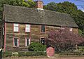
One of the oldest houses still standing is the Deane Winthrop House. It was the home of Governor Winthrop's youngest son, Deane Winthrop. He lived there until he died in 1704. This house is the oldest home in the United States that has been lived in continuously. You can visit it at certain times. The Winthrop Improvement and Historical Association takes care of the house.
In 1739, the areas that are now Chelsea, Revere, and Winthrop left Boston. They became the Town of Chelsea. In 1775, people from Chelsea played a big part in the Battle of Chelsea Creek during the American Revolutionary War. Later, in 1846, Revere and Winthrop separated from Chelsea. They became North Chelsea.
Then, in 1852, Winthrop became its own town. It had a Board of Selectmen and an Open Town Meeting government. In 1920, Winthrop was the second town in Massachusetts to get a Charter for a Representative Town Meeting. This continued until 2006.
Modern Government Changes
As mentioned, Winthrop changed its government in 2005. It now has a council-manager system. This means it is legally a city, but it still prefers to be called a town. The new Town Charter started in 2006. The Board of Selectmen and Town Meeting were removed. A Town Council now makes the laws. The Council President is elected by the people, but their role is mostly ceremonial. A Town Manager is appointed to handle the town's daily operations.
Geography and Getting Around Winthrop

Winthrop is mostly surrounded by water. The town has a total area of about 8.3 square miles (21.5 km2). However, only about 2.0 square miles (5.2 km2) of this is land. The rest is water. The town government says Winthrop's land area is actually just 1.6 square miles (4.2 km2).
Winthrop is connected to land near the Belle Isle Marsh Reservation. This marsh is shared with East Boston. Winthrop was once separated from Deer Island. But the channel that separated them was filled in by a hurricane in 1938. Now, Deer Island is connected to Winthrop.
Winthrop is seen as the northern border between Boston Harbor to its west and Massachusetts Bay to its east.
Winthrop's Neighborhoods and Borders
The town has several neighborhoods and a main downtown area. These include Court Park and Cottage Park on the Boston Harbor side. On the Massachusetts Bay side, you'll find Point Shirley, Cottage Hill, Winthrop Beach, Ocean Spray, and Winthrop Highlands.
Winthrop shares borders with Revere to the north. It borders Boston to the northwest, west, and southeast. Because Logan International Airport has grown, parts of four runways are now within what used to be Winthrop's water area. By land, Winthrop is about 5.5 miles (8.9 km) from Beacon Hill in Boston.
Deer Island and Its History
Deer Island is part of Boston, but it's located in Winthrop Bay. It stopped being a true island in the 1930s when the water channel called Shirley Gut was filled in. The island has a difficult past. It was once a place where Native Americans were held during King Philip's War. It was also a quarantine station where many immigrants died. Later, it was the site of a county jail.
Today, Deer Island is home to the huge Deer Island Waste Water Treatment Plant. This plant cleans sewage for the Boston area. Even with the treatment plant, Deer Island is part of the Boston Harbor Islands National Recreation Area. It has park land for walking, jogging, sightseeing, picnicking, and fishing. There's a man-made hill that helps hide the treatment plant from Winthrop. Many Winthrop residents enjoy the island for its parks and views of Boston Harbor and the Atlantic Ocean.
Transportation in Winthrop
Massachusetts Route 145 is the only state road that goes through Winthrop. It's also the only road connecting the town to the mainland. It comes from the Orient Heights area of East Boston. Then it loops around the main part of Winthrop before leaving to the north.
Two bus routes are provided by Paul Revere Transportation. These buses run from Point Shirley through the town and end at Orient Heights. This bus service started in 1991. It is supported by the MBTA. The buses are Route 712 (Point Shirley or Winthrop Beach to Orient Heights Station via Winthrop Highlands) and Route 713 (Point Shirley or Winthrop Beach to Orient Heights via Winthrop Center).
Before 1991, Rapid Transit operated the bus service. This began in 1940, after the Boston, Revere Beach and Lynn Railroad (called the "Narrow Gauge") closed. That railroad used to have a Winthrop Branch with nine stations.
The Blue Line subway system has stops near Winthrop. These include Orient Heights Station, Suffolk Downs Station, and Beachmont Station. All of these are close to the town's borders. There is also a ferry service from the public landing that crosses Boston Harbor. The town runs this service from May to October, connecting Winthrop, Quincy, and Rowes Wharf.
Winthrop's Population and People
| Historical population | ||
|---|---|---|
| Year | Pop. | ±% |
| 1860 | 544 | — |
| 1870 | 532 | −2.2% |
| 1880 | 1,043 | +96.1% |
| 1890 | 2,726 | +161.4% |
| 1900 | 6,058 | +122.2% |
| 1910 | 10,132 | +67.2% |
| 1920 | 15,455 | +52.5% |
| 1930 | 16,852 | +9.0% |
| 1940 | 16,768 | −0.5% |
| 1950 | 19,496 | +16.3% |
| 1960 | 20,303 | +4.1% |
| 1970 | 20,335 | +0.2% |
| 1980 | 19,294 | −5.1% |
| 1990 | 18,127 | −6.0% |
| 2000 | 18,303 | +1.0% |
| 2010 | 17,497 | −4.4% |
| 2020 | 19,316 | +10.4% |
| 2022 | 18,510 | −4.2% |
| Source:
|
||
Based on the census from 2000, there were 18,303 people living in Winthrop. There were 7,843 households and 4,580 families. The town had about 9,208 people per square mile (3,555 per km2).

In 2000, 18.6% of the population was under 18 years old. About 16.5% were 65 years or older. The average age was 40 years. For every 100 females, there were about 88.8 males.
The average income for a household in Winthrop was $53,122. For families, the average income was $65,696. About 5.5% of the population lived below the poverty line. This included 4.1% of those under 18.
Local Businesses and Services
By the mid-1990s, large shopping malls nearby started to affect small businesses in Winthrop. However, a strong community of small businesses still exists in the town.
On Great Head (Water Tower Hill) is the Winthrop Water Tower. It is red, white, and blue. It can hold 1 million US gallons (3,800 m3) of water. Winthrop's Water Department takes care of it.
The town has four main business areas: the Shirley Street Business District, the Highlands District, the center, and Magee's Corner District. In 2017, Massachusetts Governor Charlie Baker gave Winthrop $2.38 million. This money was to help improve the Center Business District.
Winthrop has a weekly newspaper called the Winthrop Sun Transcript. It shares local news, events, and town concerns.
Education in Winthrop
Winthrop has four schools that are part of Winthrop Public Schools:
- Winthrop Middle School, for grades 6–8
- Winthrop High School, for grades 9–12
- Arthur T. Cummings Elementary School, for grades 3–5
- William P. Gorman Fort Banks Elementary School, for grades Pre-K–2
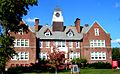
Note: Winthrop Middle School and Winthrop High School are in the same building. However, they are two separate schools with their own leaders.
Fun Places to Visit
Beaches in Winthrop
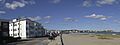
Winthrop has many beaches because it is surrounded by water. The main beaches are Winthrop Beach and Yirrell Beach. Other beaches include Donovan's Beach, Halford Beach, Pico Beach, and Short Beach.
Historic Military Forts
Winthrop has two old military forts: Fort Banks and Fort Heath. Fort Banks was built in the 1890s to protect Boston Harbor from attacks by sea. Fort Heath was built in 1898 for the same reason. Today, Fort Heath has apartment buildings, condos, and a small park overlooking the Atlantic Ocean.
Historic Places to See
Winthrop has five places listed on the National Register of Historic Places. These are important historical sites.
-
Deane Winthrop House
-
Edward B. Newton School
-
Winthrop Center/Metcalf Square Historic District
-
Winthrop Shore Drive


Recreation and Sports
Winthrop has many baseball fields and parks. Its recreation facilities also include Larsen Rink, which is an indoor ice skating rink. There's also the Winthrop Golf Course, a private 9-hole golf course.
Famous People from Winthrop
Many notable people have connections to Winthrop:
- Don and Richard Addrisi, a singing-songwriting duo
- Mark Bavaro, a former National Football League player
- Herbert Bix, a Pulitzer Prize winning author
- Robert DeLeo, a politician and former Speaker of the Massachusetts House of Representatives
- Jillian Dempsey, captain of the Boston Pride hockey team
- Rick DiPietro, a former National Hockey League goalie
- Mike Eruzione, a former ice hockey player and captain of the 1980 US Olympic team in the famous Miracle on Ice game
- Edward J. King, Governor of Massachusetts (1979–1983)
- Steven Lento, musician known as Steven Van Zandt from Bruce Springsteen's E Street Band
- Daniel Lopatin, electronic musician known as Oneohtrix Point Never
- Sylvia Plath, a famous poet
- Benjamin Lee Whorf, a linguist
- Richard Whorf, an actor
See also
 In Spanish: Winthrop (Massachusetts) para niños
