
Fort Banks (Massachusetts) facts for kids
Quick facts for kids Fort Banks |
|
|---|---|
| Part of Harbor Defenses of Boston | |
| Winthrop, Massachusetts | |

Fort Banks
Location in Massachusetts
|
|
| Coordinates | 42°23′03″N 70°58′49″W / 42.38417°N 70.98028°W |
| Site information | |
| Owner | Massachusetts |
| Controlled by | Town of Winthrop |
| Open to the public |
Yes |
| Condition | partly buried |
| Site history | |
| Built | 1890s |
| Built by | United States Army |
| In use | 1890s-1947 |
| Battles/wars | World War I World War II Cold War |
Fort Banks was a special fort built by the U.S. Army in Winthrop, Massachusetts. Its main job was to protect Boston Harbor from enemy ships. It was built in the 1890s during a time called the Endicott period. This was when the United States greatly improved its coastal defenses with new technology.
Today, the Fort Banks Mortar Battery is a historic site. It is listed on the National Register of Historic Places. During World War II, Fort Banks was very important. It was the main command center for Boston's harbor defenses. Soldiers even called it "The Country Club" because it was a nice place to be stationed. The fort was named after Nathaniel P. Banks, a famous general and former governor of Massachusetts.
Contents
Building the Fort
Work on Fort Banks started in 1892. The plan was to build four large pits for mortars. Each pit would hold four huge 12-inch mortars. These powerful guns could fire a half-ton shell over six miles out to sea. This meant they could protect the northern parts of Boston Harbor.
The mortar pits were finished in 1896. This made Fort Banks the oldest Endicott period fort in Boston's harbor defenses. The two eastern pits were called Battery Sanford Kellogg. The two western pits were called Battery Benjamin Lincoln. These were the first 12-inch mortar batteries finished in the U.S. The mortars were removed in 1942. In 2007, the fort became a historic landmark.
The four mortar pits were arranged in a special way called an "Abbot Quad." This design put 16 mortars in a square shape. The idea was that if all 16 mortars fired at once, their shells would land around an enemy ship. This would be like a giant shotgun blast. Each shell weighed over 1,000 pounds. So, 16 shells would be over 8 tons of steel and explosives! This was meant to scare away any ships trying to enter Boston Harbor. The Army actually wanted to build two of these 16-gun setups, but they ran out of money.
The Mortars

The 12-inch mortars at Fort Banks were some of the strongest guns of their time. The fort first had older M1886 mortars. But these were replaced with the M1890MI (Model 1890 Modification I) 12-inch mortars between 1911 and 1915. These mortars could fire two types of shells: high explosive or armor-piercing. The high explosive shells weighed 700 pounds. The armor-piercing shells weighed either 700 or 1,046 pounds. When firing the heavier shells, these mortars could hit targets about 7 miles away.
Each M1890MI mortar was very heavy, weighing about 78.5 tons. It had special gears to turn it and raise or lower it. When a mortar fired, the shock wave was very strong. It could damage nearby equipment, break windows, and even knock doors off buildings.
A fully working mortar pit needed a lot of soldiers. There was a pit commander, two groups of 17 soldiers for the mortars, and 16 soldiers for ammunition. A small concrete room called a "data booth" was built into the pit wall. This booth received information from the plotting room. This information told the soldiers how to aim the mortars to hit their targets.


Battery Areas
The fort's battery areas included the surface pits, underground storage rooms (magazines), and connecting tunnels. These underground areas are not open to the public.
Battery Layout
The battery diagram shows the layout with east at the top. The main corridor running through the middle is about 430 feet long. The original walls of the mortar pits, built in 1896, were narrower. They were rebuilt between 1910 and 1914 to be wider. This was because the smaller design didn't leave enough room for the mortars to be used properly.
The original tunnels, built in 1896, were meant to store all the ammunition and powder. Old plans show rows of shells stored along these tunnels. There was a system of shell trolleys to move the heavy shells to the pits. Later, switches were added to these trolleys to access different stacks of shells.
Between 1910 and 1914, more storage rooms were added. These new rooms greatly increased the fort's storage capacity. Originally, all these storage rooms were covered with 10 to 20 feet of earth. This protected them from enemy shells and bombs. During World War I, some mortars were removed from the pits. This was done to make the remaining mortars fire faster. The removed mortars could then be used as railway artillery.
World War II
During World War II, Fort Banks was a busy place. It had a command post for anti-aircraft defense. It also had a weather station and a secure telephone switchboard bunker. At one point, it was the headquarters for the Army's 9th Coast Artillery Regiment. This group protected much of Boston Harbor. The 241st Coast Artillery Regiment also used the fort as a headquarters. Fort Banks even had a hospital with 250 beds. After the war, in 1947, the Army no longer needed the fort. The Town of Winthrop bought the land for town buildings and apartments.
Cold War
In the 1950s, Nike anti-aircraft missiles were placed at Fort Banks. In 1959, parts of an advanced radar system were set up there. This was for a test by NORAD to improve air defense.
Historical Marker
There is a plaque at the fort that tells a sad story. On October 15, 1904, a terrible accident happened during a practice firing. A mortar fired too early, before it was properly closed. This accident killed four people and injured nine others.
Today, parts of Fort Banks are used for different things. Some of the old storage rooms are filled with items from a "haunted house" event. The two western mortar pits have been partly filled in and paved over. They are now used as parking lots. The central command building has fire damage. The rooms of Battery Lincoln's flank magazines are now used by maintenance staff for nearby apartments.
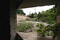
Most of the fort's original structures are gone. Only one of the four mortar pits, Pit B of Battery Kellogg, is still mostly in its original condition. The Town of Winthrop excavated it in 1992, so you can still see much of its floor. The Winthrop Department of Public Works (DPW) uses parts of Battery Kellogg for storage. Property managers for nearby apartments use parts of Battery Lincoln for offices and storage.
Images for kids
-
A view from inside the data booth of Btty Kellogg Pit B
-
The outside entrance to Battery Kellogg Pit B
-
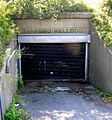
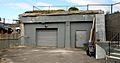
The bombproof telephone switchboard bunker 42°23′05″N 70°58′52″W / 42.384664°N 70.981048°W
-
One of the former shell rooms in the central magazine, Btty Lincoln
-
The west face of the flank magazines of Btty Lincoln, Pit A
-

Inside view of the Btty Lincoln Pit A flank magazines shows the original doorway openings.
-
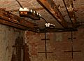
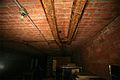
Two switches, operated by handles on the wall, moved shells between tracks running along ceiling of a shell room.
-

This "obelisk" on the hill west of Btty Kellogg Pit B is in fact a chimney.42°23′03″N 70°58′51″W / 42.384271°N 70.980735°W
-
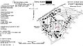
A 1938 map of the fort
-
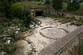
View of Btty Kellogg Pit B looking southwest
-
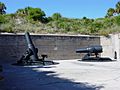
12-inch mortars (1890 M1) like those at Fort Banks
-

Detail of 1896 plan, showing west end of central magazine
-
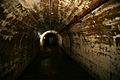
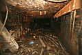
A typical view of the central E-W corridor, built in 1896 as a magazine
-
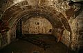
An 1896 shell/powder storage chamber for Btty Kellogg
-
A shell trolley with a switch to move shells from rail to rail


