
Fort Heath facts for kids
Quick facts for kids Fort Heath |
|
|---|---|
| Part of Harbor Defenses of Boston | |
| location: Winthrop Highlands at Grovers Cliff | |

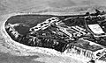
Southeastward view with the face of Grovers Cliff along foreground shore, large rectangular white area on west (right). Pictured items not on the 1921 map include the roads through the barracks area connecting to the off-post intersection that is now the Highland Av & Pond St intersection (right).
|
|

Fort Heath
Location in Massachusetts
|
|
| Coordinates | 42°23′22.36″N 70°58′10.15″W / 42.3895444°N 70.9694861°W |
| Type | coastal artillery site and radio/radar station eponym: General William Heath (Continental Army) namesake: Fort Heath Apartments |
| Site information | |
| Owner | private and municipal |
| Condition | private apartment complex and municipal park |
| Site history | |
| Built | c. 1898 |
| In use | 1898–1966 |
| Demolished | 1947 – buildings 1969 – control site tbd – nuclear bunker 1979–1980 – FAA radar & building |
| Battles/wars | World War I World War II Cold War |
Fort Heath was an important military base in Winthrop, Massachusetts. It was built to protect Boston Harbor from attacks by sea. The fort was active from 1898 to 1966.
Over the years, Fort Heath had many roles. It was a Coast Artillery fort with large guns. It also hosted a Coast Guard radio station and a Navy research center. During World War II, it had special batteries to defend against attacks. Later, in the Cold War, it became a radar station.
Today, the military buildings are gone. In their place, you'll find apartments and a public park. This park, called Small Park, has a special wall and a marker to remember the fort's history.


Contents
Building Fort Heath: A Stronghold for Boston
The area where Fort Heath stands was first called Grover's Cliff Military Reservation in 1895. Before that, in 1847, a survey marker was placed there to map the land.
In 1890, plans were made for the military site. They wanted to install 3 large artillery rifles and 16 mortars. Construction began in spring 1898, just before the Spanish-American War. A special railroad line was built to bring supplies to the site.
Soldiers from the regular army arrived in May 1898 to prepare for the mortars. The first concrete foundation for a large "disappearing gun" was finished that same month. In 1900, the site was officially named Fort Heath.
The Powerful Guns of Battery Theodore Winthrop
By 1901, the main gun battery, named Battery Theodore Winthrop, was complete. It had three huge 12-inch guns. These guns were mounted on special "disappearing carriages." This meant the guns would pop up to fire and then drop back down behind a wall for protection. These were the heaviest guns used by the United States Army Coast Artillery Corps at that time.
Major Morris was the first commander of these powerful guns. Soldiers from "Batteries P and O of the Regular Army" operated them. In 1908, the fort also had a "range-finders house" to help aim the guns. A sea wall was built along the southern shore by 1921 for extra protection.
During World War I, Fort Heath played an important role. It had the main stations for aiming guns, working with other forts like Fort Banks.
Fort Heath's Role in Communication and Defense
After 1925, the fort's purpose shifted slightly. In 1932, some old equipment, like ammunition hoists, were removed.
The Coast Guard Radio Station
On November 12, 1931, the United States Coast Guard opened a radio station at Fort Heath. Its call sign was "NMF." This station was used to test how well radio messages could be sent across long distances.
The station had three tall, 50-foot masts in 1934. For a short time, from 1934 to 1936, the station closed for testing. The Coast Guard wanted to see if the Navy could handle all their radio traffic. The station reopened and operated until 1939. Then, the Army took over the site, and the Coast Guard moved its equipment to a new location in North Truro, Massachusetts.
Anti-Aircraft Defense: AA Battery No. 4
In 1935, Fort Heath added Antiaircraft Battery No. 4. This battery had three 3-inch (76 mm) anti-aircraft (AA) guns. These guns were designed to shoot down enemy airplanes. The first two gun pads for these guns were built during World War I.
The three gun positions were located south of a radar system. In January 1942, during World War II, these guns were approved to be moved to Fort Ruckman.
By 1938, the United States Navy set up a Field Test Station at Fort Heath. This station included a research facility from the Massachusetts Institute of Technology. They worked on "fire-control systems," which are technologies that help aim and fire weapons accurately.
Protecting the Harbor: AMTB Battery 945
During World War II, Anti-Motor Torpedo Boat (AMTB) Battery 945 was built at the eastern tip of Fort Heath. This battery had two 90 mm guns. Their job was to protect the northern approaches to Boston Harbor from fast-moving enemy torpedo boats.
On June 1, 1941, the 3rd Battalion of the 9th Coast Artillery Regiment was activated at Fort Heath. From September to November 1941, the fort also hosted a camouflage training school. Battery 945 was declared no longer needed on December 28, 1943. Today, a very large apartment building stands where Battery 945 once was.
Fort Heath in the Cold War: A Radar Station

From 1960 to 1969, Fort Heath became a Cold War radar station. It was a control center for both the Air Force and the Army. Its main job was to coordinate fighter jets and Project Nike surface-to-air missiles. These missiles were part of the air defense system for the Boston and Providence areas.
From 1959 to 1962, the 820th Radar Squadron operated the Air Force part of the facility. The station also had an FAA radar system called ARSR-1A, which helped track air traffic. The air defense control site was torn down in 1969. The large underground bunker remained until at least 1971. By 1974, the remaining Nike missile batteries were closed.
Small Park: Fort Heath Today
The FAA continued to operate its radar system at Fort Heath until the mid-to-late 1990s. By 2005, the land that once belonged to Fort Heath was bought by the town. It was then turned into a public park for everyone to enjoy. The area is now known as a Formerly Used Defense Site (MA19799F184300).
Images for kids
-
Southeastward view with the face of Grovers Cliff along foreground shore, large rectangular white area on west (right).
-
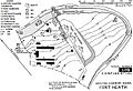
Fort Heath map of "FEB. 17, 1921" with added modern annotation to "roughly" indicate a former survey marker in the roof of the southernmost of the "BC" buildings (top—6 small adjoining blocks).
-
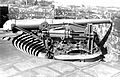
This disappearing carriage at Battery Alexander or Battery Bloomfield at Fort Hancock, New Jersey (above) was the same model (M1896) as at Ft Heath, and the recessed gun pits were similar. The 12-in gun (top) is an M1888.
-
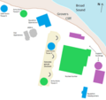
The Missile Master nuclear-hardened bunker (green) was the largest structure of the Fort Heath radar station.
