Grovers Cliff facts for kids
Quick facts for kids Grovers Cliff |
|
|---|---|

|
|
| Location | Massachusetts, United States |
| Coordinates | 42°23′25″N 070°58′08″W / 42.39028°N 70.96889°W |
| Geology | Escarpment & Headland |
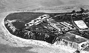
Grovers Cliff is a special piece of land in Winthrop, Massachusetts. It's a steep cliff along the coast, right by Broad Sound and close to the Port of Boston. This land also sticks out into the sea, forming what's called a headland.
This area is known as the "Highlands" section of Winthrop. It sits at the northern end of Winthrop Beach. Grovers Cliff has a rich history, from old survey stations to important military sites.
A Look at Grovers Cliff's History
Grovers Cliff has been an important spot for a long time. In 1847, surveyors used it as a key point to map the area. Later, it became a very important military location.
Fort Heath: A Military Past
During World War I and World War II, Grovers Cliff was home to Fort Heath. This fort was built to protect the coast. It played a big role in defending the area during these major global conflicts.
After these wars, during the Cold War, a special underground shelter was built here. This was a "nuclear bunker" designed to be very strong. It was used by different parts of the United States military, including the Army, Coast Guard, Navy, and Air Force. The FAA, which manages air traffic, also used it.
From Forts to Apartments
Today, Fort Heath is no longer an active military base. The landform's current apartment complex is named after the old fort. This means the name "Fort Heath" lives on, even though its purpose has changed.
A northern part of the headland is now a public green space called Small Park. The rest of the area is mostly taken up by the Fort Heath Apartments. Streets like Highland Avenue and Pond Street were built around the edges of the old Fort Heath by the 1930s.
 | James Van Der Zee |
 | Alma Thomas |
 | Ellis Wilson |
 | Margaret Taylor-Burroughs |

