
Fort Ruckman facts for kids
Quick facts for kids Fort Ruckman |
|
|---|---|
| Part of Harbor Defenses of Boston | |
| Nahant, Massachusetts | |

A casemated 12-inch gun like those at Fort Ruckman.
|
|

Fort Ruckman
Location in Massachusetts
|
|
| Coordinates | 42°25′14.25″N 70°55′48.86″W / 42.4206250°N 70.9302389°W |
| Type | Coastal Defense |
| Site information | |
| Owner | Massachusetts |
| Controlled by | Town of Nahant |
| Open to the public |
yes |
| Condition | partly buried |
| Site history | |
| Built | 1924 |
| Built by | United States Army |
| In use | 1924-1946 |
| Battles/wars | World War II |

Fort Ruckman was a military fort built to protect the coast of Nahant, Massachusetts. It was first called the Nahant Military Reservation. The fort was planned between 1904 and 1907. It covered about 45 acres (18 hectares) near Bass Point on the Nahant peninsula. In the 1920s, the fort was renamed to honor Major General John Wilson Ruckman. He was a former Colonel in the Coast Artillery, a branch of the army that used large guns to defend coastlines.
After World War II, Fort Ruckman was no longer needed by the military. The land was sold in 1947 to the town of Nahant and to private owners. A tall structure called a fire control tower was part of the fort. This tower helped soldiers aim the big guns. Later, in the 1940s and 1950s, this tower was used for radar research. It even had a large radar antenna on its roof at one point. Another radar, used for tracking targets, was also set up nearby on Bayley's Hill.
Contents
Protecting Boston Harbor
During World War II, Fort Ruckman was an important part of the Harbor Defenses of Boston. This was a system of forts and guns designed to protect Boston's harbor from enemy attacks. Fort Ruckman had a special command center for the northern part of these defenses.
Battery Gardner's Big Guns
The fort was home to a powerful gun battery called Battery Gardner. This battery had two very large 12-inch guns. These guns were placed inside strong concrete rooms called casemates. These casemates were built just before World War II. They covered the original open gun positions that were finished in 1923.
The guns were known as the 12-inch M1895 gun. They were mounted on special carriages that allowed them to shoot very far. When they were installed, these were the biggest guns in the Boston harbor defenses. Each gun weighed a massive 151 tons. They could shoot a shell about 29,300 yards (about 16.6 miles). This huge range meant the guns could protect a wide area. They could reach from Gloucester in the north to North Scituate in the south. The two gun positions were about 425 feet (130 meters) apart.
Underground Tunnels and Storage
Today, much of the fort's original area has been turned into homes, parks, and recreation areas. There were many concrete tunnels and rooms built underground between the two main gun positions. These tunnels were used for many things. They held equipment for aiming the guns, stored ammunition, and provided living quarters for the soldiers.
During the construction of the casemates, these underground areas were buried under about 20 feet (6 meters) of earth. Even though they are buried, these tunnels can still be accessed. The town of Nahant now uses them for storage. On the surface above these buried tunnels, you can see concrete chimneys. These chimneys help to ventilate the underground rooms. A special marker, called a geodetic disk, was placed here in 1943. It likely helped the soldiers aim the big 12-inch guns accurately.
Anti-Aircraft Defenses
About 800 feet (240 meters) northwest of Battery Gardner, there was another battery of guns. This one was for anti-aircraft defense. It was known as Location 130-2C, or the Boston Harbor No.4 AAA Battery. AAA stands for Anti-Aircraft Artillery. This battery had three 3-inch guns. These guns were placed on the surface in a triangle shape, with each side about 150 feet (46 meters) long.
These anti-aircraft gun positions were built in 1934. However, the guns themselves were not installed until 1942, during World War II. The final construction of this battery was completed very quickly, in less than a month, starting on May 5, 1942. Today, it looks like these gun positions have been removed. Their original location would be near the left field foul pole of the first baseball field southeast of the corner of Castle and Flash Roads.
Images for kids
-
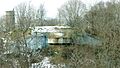
One of the two 12-inch gun positions and a fire control tower (at left) for Battery Gardner at Ft. Ruckman.
-
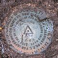
This special disk helped soldiers aim the guns. It's located above the buried tunnels of Battery Gardner.


