
Charles River Esplanade facts for kids

The Charles River Esplanade is a beautiful park in Boston, Massachusetts. It sits along the south bank of the Charles River. This park is a favorite spot for many people in the city. It offers a green space for fun and relaxation.
Contents
Discover the Charles River Esplanade
The Esplanade is a long, narrow park. It stretches along the Charles River. A busy road called Storrow Drive runs along its southern side. The park is a perfect place for outdoor activities.
What You'll Find Here
You can walk, run, or bike on the many paths. There are also cool statues to see. The Hatch Memorial Shell is a famous outdoor stage. Many concerts and events happen there. Kids can enjoy playgrounds and ballfields. You can even go boating on the river. The Esplanade is part of the larger Charles River Reservation state park. It became a special Boston Landmark in 2009.
A Park with a Past
The Esplanade started as the "Boston Embankment" in 1910. It was built when the Charles River Dam Bridge was constructed. This bridge is now near the Museum of Science. At first, people thought the park needed more trees and fun things to do. It connected to Frederick Law Olmsted's Emerald Necklace park system. To make it better, trees were planted. They also added a snack stand and started holding concerts.
How the Park Grew
The park got much bigger between 1928 and 1936. A generous donation helped make these improvements. This donation was from Helen Storrow in memory of her husband, James J. Storrow. The new design added lagoons, boat docks, and playgrounds. It also included a Music Oval for performances.
Music and Fun at the Hatch Shell
In 1929, the Boston Pops orchestra began performing here. They played music for everyone to enjoy. The famous Hatch Memorial Shell was built in 1941. This gave the Pops a great stage for their summer shows. Today, hundreds of thousands of people gather here. They come for the Boston Pops concert and fireworks on Independence Day. The Hatch Shell also hosts free concerts, movies, and special events. These events include walkathons and festivals like Earth Day.
Boating Adventures
Sailing on the Charles River became popular in the 1930s. The boathouse on the Esplanade was built in 1941. In 1946, Community Boating started. It was the first public boating program in the country. For a small fee, many people have learned to sail here.
Getting Around the Esplanade
A big change happened in 1949 with the building of Storrow Drive. To replace the park land used for the road, new paths and islands were added. In the 1960s, the Esplanade connected to other parks. This happened with the creation of the Dr. Paul Dudley White Bike Path. This path is about 18 miles (29 km) long. It goes along both sides of the river. It's perfect for biking, inline skating, and running.
How to Get to the Esplanade
The Esplanade is separated from Boston neighborhoods by Storrow Drive. This is a fast road with fences. To get into the park, you use special bridges. There are eight pedestrian bridges. Two more bridges are at the very ends of the park. Here are some of them, listed from east to west:
- Leverett Circle bridge
- Blossom Street bridge
- Frances Appleton Bridge (near Longfellow Bridge)
- Arthur Fiedler Bridge (leads to the Hatch Shell)
- Dartmouth Street bridge
- Fairfield Street bridge
- Harvard Bridge (at Massachusetts Avenue)
- Silber Way bridge
- Boston University Marsh Chapel bridge
Images for kids
-
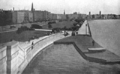
Esplanade, around 1916
-
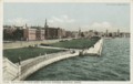
A postcard showing the Esplanade, from the 1910s–1920s
-
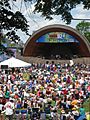
The Hatch Shell in 2009
-
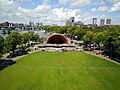
An aerial view of the Hatch Shell on the Esplanade
-
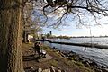
The Esplanade, near the Community Boating boathouse, 2010
-
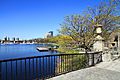
Charles River Esplanade, 2013
-
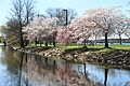
Charles River Esplanade, 2013
-

The Night Shift Brewing Owl's Nest Beer Garden on the Esplanade in 2018.


