
Harvard Bridge facts for kids
Quick facts for kids Harvard Bridge |
|
|---|---|

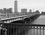
Seen from Cambridge (2017)
|
|
| Coordinates | 42°21′16″N 71°05′29″W / 42.35457°N 71.09132°W |
| Carries | |
| Crosses | Charles River |
| Locale | Boston–Cambridge, Massachusetts, United States |
| Maintained by | MassDOT |
| ID number | B160124EYDOTNBI |
| Characteristics | |
| Design | Haunched girder bridge |
| Material | Steel |
| Total length | 2,164.8 ft (387.72 sm; 659.82 m) (roadway) 364.4 smoots ± one ear (620 m) (sidewalk from Storrow Drive to Cambridge only) |
| Width | 69.3 ft (12.42 sm; 21.13 m) (total width) 52 ft (9.3 sm; 15.8 m) (roadway) |
| Number of spans | 25 |
| Piers in water | 24 |
| Load limit | 86.4 short tons (78.4 t) |
| Clearance below | 12 ft (2.2 sm; 3.7 m) |
| History | |
| Constructed by | Boston Bridge Works |
| Construction begin | 1887 |
| Construction end | 1891 |
| Opened | September 1, 1891, 1990 |
| Closed | 1983 (temporary closure for repairs) |
| Statistics | |
| Daily traffic | 49,000 as of 2005 |
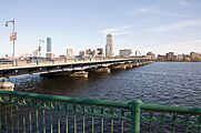
The Harvard Bridge is a famous bridge connecting Boston and Cambridge, Massachusetts. It carries Massachusetts Avenue (also known as Route 2A) over the Charles River. People sometimes call it the MIT Bridge or the "Mass. Ave." Bridge.
This bridge is the longest one over the Charles River, stretching about 660 meters (2,165 feet). It's made of steel and was built between 1887 and 1891. The bridge is named after John Harvard, who founded Harvard University.
One of the most unique things about the Harvard Bridge is that its sidewalk is measured in a funny unit called the smoot. This special measurement was created by students from MIT!
Contents
Building the Harvard Bridge
For many years, the cities of Boston and Cambridge couldn't agree on building a bridge. Finally, in 1887, the state government stepped in. They decided that both cities had to work together and share the costs.
A special group, called a bridge commission, was formed to oversee the project. It included the mayors of Boston and Cambridge, plus a third person they chose. This group helped make sure the bridge got built.
The bridge was expected to cost around $500,000 back then. This was a huge amount of money in the late 1800s!
Why the Name "Harvard Bridge"?
The bridge is named after Reverend John Harvard. He was a very important person who helped start Harvard University. So, the bridge honors him, not the university itself. Other names were suggested, but Harvard was chosen.
How the Bridge Was Designed
The first ideas for the bridge involved a wooden structure. But engineers decided to build it with strong iron spans on stone supports instead. This made the bridge much more durable.
The ground under the bridge was tricky. There's a lot of clay and even a fault line. So, the engineers had to be very careful with the foundations. The bridge has many stone piers (supports) and was originally designed with a part that could swing open for boats.
When it first opened on September 1, 1891, the bridge had two lanes for horse-drawn carriages and two tracks for streetcars. There were also sidewalks for people to walk on. The total cost to build it was about $511,000.
Keeping the Bridge in Good Shape
Over the years, the Harvard Bridge has seen many changes and repairs to keep it safe and useful.
Bike Lanes and Famous Jumps
In 1898, special lanes for bicycles were added next to the curbs. It took a long time, but in 2011, these lanes finally connected to Boston's wider bike lane network.
The bridge is also famous for a daring stunt! In 1908, the famous magician Harry Houdini jumped from the bridge as part of one of his amazing escapes.

Major Upgrades Over Time
By 1909, parts of the bridge were declared unsafe, and much of the iron and steel had to be replaced. Later, in 1924, the Metropolitan District Commission (MDC) took over the bridge. They made big changes, replacing wooden parts with steel and concrete. The old swing section was also changed into two fixed spans, making the bridge a consistent width all the way across.
The bridge used to be called the "Xylophone Bridge." This was because of the sound its wooden deck made when cars drove over it! In 1949, this wooden deck was replaced with concrete and a new surface. The old trolley tracks were removed, and their poles were reused for street lights.
Making the Bridge Stronger
In the early 1970s, people noticed the bridge vibrated a lot. Engineers studied it and found it wasn't strong enough for the heavy traffic. They suggested limiting the weight of vehicles crossing it.
Then, in 1983, another bridge in Connecticut collapsed. Because the Harvard Bridge had similar parts, it was immediately closed for inspection. Engineers found some broken hangers, so trucks and buses were banned from the bridge.
This led to a huge project in the late 1980s to replace the entire top part of the bridge (the superstructure). The goal was to make it much stronger and safer, using modern steel. The new design also made sure the bridge looked similar to its historic appearance. This big project finished in 1990.
- Before-and-after images
-
The bridge in 1985, before the big repairs. You can see traffic cones blocking outer lanes.
-
The same view in 2009, after the new top part was built. It looks much better!
.jpg)

-
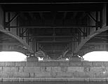
What the underside of the bridge looked like in 1985, showing its original construction and earlier changes.
-
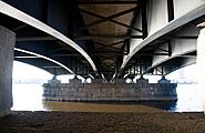
The underside in 2009, showing the new, stronger design with six main beams.


New Lights and Bike Lanes
In 2015, new streetlights were installed on the bridge. These lights make it safer for everyone and highlight the special smoot marks on the sidewalk.
To make cycling even safer, in 2021, MassDOT (the state's transportation department) started a pilot program. They added separated bike lanes using cones. This was a big success! By 2023, these separated bike lanes, along with special bus lanes, became permanent. The Harvard Bridge is now one of the most popular places for cyclists in New England. More than 1,000 bicyclists cross it in each direction every day.
The Famous Smoots

The Harvard Bridge is famous for its unique unit of measurement: the smoot.
In 1958, a group of students from MIT decided to measure the bridge. They used one of their shortest friends, Oliver Smoot, as their measuring stick! Oliver was about 5 feet 7 inches tall.
They marked the bridge's eastern sidewalk every 10 smoots. The bridge is officially marked as 364.4 smoots long, "plus one ear." This "plus one ear" part was a funny way to show there was a tiny bit left over.
The students from the Lambda Chi Alpha fraternity still repaint these marks regularly. Even bridge officials use the smoot marks as reference points in accident reports! During the big reconstruction in the 1980s, the new sidewalks were even built with smoot-length slabs.

See also
 In Spanish: Puente de Harvard para niños
- List of crossings of the Charles River
