Little Suncook River facts for kids
Quick facts for kids Little Suncook River |
|
|---|---|

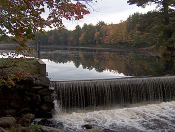
Cass Pond on the Little Suncook in Epsom, New Hampshire
|
|
| Country | United States |
| State | New Hampshire |
| County | Merrimack |
| Town | Epsom |
| Physical characteristics | |
| Main source | Northwood Lake Epsom 517 ft (158 m) 43°13′11″N 71°17′26″W / 43.21972°N 71.29056°W |
| River mouth | Suncook River Epsom 325 ft (99 m) 43°13′25″N 71°21′19″W / 43.22361°N 71.35528°W |
| Length | 4.0 mi (6.4 km) |
| Basin features | |
| Tributaries |
|
The Little Suncook River is a small river in central New Hampshire, United States. It is about 4 miles (6.4 km) long. This river is a tributary of the Suncook River. This means it flows into the Suncook River. The Suncook River then flows into the Merrimack River. All these rivers are part of the larger Gulf of Maine watershed.
Contents
About the Little Suncook River
The Little Suncook River is an important part of the local water system. It helps carry water from lakes and smaller streams. This water eventually reaches the ocean. Rivers like the Little Suncook are home to many plants and animals. They also provide water for people.
Where the River Starts and Flows
The Little Suncook River begins at Northwood Lake. This lake is located in the town of Epsom. From there, the river flows towards the west. It passes through a pond called Bixby Pond. This pond is also known as Cass Pond. The river then flows past the small villages of Epsom and Gossville. Finally, it joins the Suncook River. This meeting point is near the Epsom Traffic Circle.
Connecting to Other Rivers
The Little Suncook River is a key part of a larger river system. It feeds into the Suncook River. The Suncook River then flows into the Merrimack River. The Merrimack River is one of the largest rivers in New England. It eventually empties into the Atlantic Ocean. This whole system helps drain water from a wide area.
Roads and the River
A major road, U.S. Route 4, follows the Little Suncook River. This road runs right next to the river for its entire length. This means you can often see the river if you are driving on Route 4 in this area. Roads often follow rivers because rivers create natural valleys. These valleys are good places to build roads.
 | William M. Jackson |
 | Juan E. Gilbert |
 | Neil deGrasse Tyson |


