Chichester, New Hampshire facts for kids
Quick facts for kids
Chichester, New Hampshire
|
||
|---|---|---|

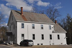
Chichester Grange Hall, which houses town offices, is listed in the State Register of Historic Places
|
||
|
||

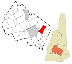
Location in Merrimack County and the state of New Hampshire
|
||
| Country | United States | |
| State | New Hampshire | |
| County | Merrimack | |
| Incorporated | 1727 | |
| Villages |
|
|
| Area | ||
| • Total | 21.29 sq mi (55.15 km2) | |
| • Land | 21.19 sq mi (54.88 km2) | |
| • Water | 0.10 sq mi (0.27 km2) 0.50% | |
| Elevation | 538 ft (164 m) | |
| Population
(2020)
|
||
| • Total | 2,665 | |
| • Density | 126/sq mi (48.6/km2) | |
| Time zone | UTC-5 (Eastern) | |
| • Summer (DST) | UTC-4 (Eastern) | |
| ZIP code |
03258
|
|
| Area code(s) | 603 | |
| FIPS code | 33-12420 | |
| GNIS feature ID | 0873566 | |
Chichester is a small town in Merrimack County, New Hampshire, United States. It's a great place to learn about New England history and nature. In 2020, about 2,665 people lived here.
Contents
History of Chichester
Chichester became an official town in 1727. It was named after the Earl of Chichester, a powerful person in England at the time. The first people started settling here in 1758.
Geography and Nature
Chichester covers about 55 square kilometers (around 21 square miles). Most of this area is land, with a small part being water.
The highest point in Chichester is a hill about 309 meters (1,015 feet) above sea level. This hill is close to Garvin Hill and Plausawa Hill.
Water flows from Chichester into two main rivers: the Soucook River and the Suncook River. Both of these rivers eventually join the larger Merrimack River.
Town Layout
Chichester is not very crowded. Most of the shops and businesses are found along two main roads: US 202 (also called Dover Road) and NH 28 (Suncook Valley Road).
The center of town has important buildings like the town hall and the Methodist church. This area is where Main Street, Canterbury Road, and Center Road meet.
Neighboring Towns
Chichester shares its borders with a few other towns:
- Loudon (to the northwest)
- Pittsfield (to the northeast)
- Epsom (to the east)
- Pembroke (to the south)
Population Over Time
| Historical population | |||
|---|---|---|---|
| Census | Pop. | %± | |
| 1790 | 491 | — | |
| 1800 | 775 | 57.8% | |
| 1810 | 951 | 22.7% | |
| 1820 | 1,010 | 6.2% | |
| 1830 | 1,084 | 7.3% | |
| 1840 | 1,028 | −5.2% | |
| 1850 | 997 | −3.0% | |
| 1860 | 1,041 | 4.4% | |
| 1870 | 871 | −16.3% | |
| 1880 | 784 | −10.0% | |
| 1890 | 661 | −15.7% | |
| 1900 | 598 | −9.5% | |
| 1910 | 606 | 1.3% | |
| 1920 | 507 | −16.3% | |
| 1930 | 567 | 11.8% | |
| 1940 | 587 | 3.5% | |
| 1950 | 735 | 25.2% | |
| 1960 | 821 | 11.7% | |
| 1970 | 1,083 | 31.9% | |
| 1980 | 1,492 | 37.8% | |
| 1990 | 1,942 | 30.2% | |
| 2000 | 2,236 | 15.1% | |
| 2010 | 2,523 | 12.8% | |
| 2020 | 2,665 | 5.6% | |
| U.S. Decennial Census | |||
The town's population has changed a lot over the years. In 1790, there were less than 500 people. By 2020, the population had grown to 2,665.
In 2000, about 2,236 people lived in Chichester. About 37% of the homes had children under 18 living there. The average age in town was 38 years old.
Roads and Transportation
Several important roads pass through Chichester, making it easy to travel to other places.
- NH 9, U.S. Route 4, and U.S. Route 202 all run together through the town. This road is known as Dover Road. It connects Chichester to Pembroke in the west and Epsom in the east.
- NH 28 goes through the eastern part of town. It follows the Suncook River and connects Epsom to Pittsfield. This road is called Suncook Valley Road.
Famous People from Chichester
- Gordon J. Humphrey (born 1940) was a U.S. senator for New Hampshire from 1978 to 1990. A U.S. senator helps make laws for the entire country.
- Sally Kelly was a member of the New Hampshire House of Representatives from 2006 to 2014. This means she helped make laws for the state of New Hampshire.
See also
 In Spanish: Chichester (Nuevo Hampshire) para niños
 | Isaac Myers |
 | D. Hamilton Jackson |
 | A. Philip Randolph |


