
Chesterfield, New Hampshire facts for kids
Quick facts for kids
Chesterfield, New Hampshire
|
|
|---|---|
|
Town
|
|

Town hall and historical society
|
|

Location in Cheshire County, New Hampshire
|
|
| Country | United States |
| State | New Hampshire |
| County | Cheshire |
| Incorporated | 1752 |
| Villages |
|
| Area | |
| • Total | 47.5 sq mi (123.1 km2) |
| • Land | 45.6 sq mi (118.0 km2) |
| • Water | 2.0 sq mi (5.1 km2) 4.17% |
| Elevation | 853 ft (260 m) |
| Population
(2020)
|
|
| • Total | 3,552 |
| • Density | 78/sq mi (30.1/km2) |
| Time zone | UTC-5 (Eastern) |
| • Summer (DST) | UTC-4 (Eastern) |
| ZIP codes | |
| Area code(s) | 603 |
| FIPS code | 33-12260 |
| GNIS feature ID | 0873565 |
Chesterfield is a town located in Cheshire County, New Hampshire, in the United States. In 2020, about 3,552 people lived there.
Chesterfield is home to several small communities. These include the villages of Spofford and West Chesterfield. The town is also known for its beautiful natural spots. You can visit Spofford Lake, the Chesterfield Gorge Natural Area, and parts of Pisgah State Park. Wantastiquet Mountain State Forest is also partly in Chesterfield.
Contents
History of Chesterfield
How Chesterfield Was Founded
Chesterfield was first set up in 1735 by Governor Jonathan Belcher from Massachusetts. It was an important place because it had Fort Number 1. This fort was the first in a line of forts along the Connecticut River. These forts helped protect the area.
Later, the border between Massachusetts and New Hampshire was officially decided. On February 11, 1752, Governor Benning Wentworth made Chesterfield an official town. It was named after Philip Stanhope, who was the 4th Earl of Chesterfield.
Early Settlers and Life
The first people to settle in Chesterfield were Moses Smith and William Thomas. They came with their families in canoes in the fall of 1761. Life was tough at first. They mostly ate salmon and shad from the river. There were also many deer in the forests for them to hunt.
Even though it had good farmland, Chesterfield also had small factories. These factories made things like parts for spinning wheels and hand tools.
Methodist Church History
In 1772, Philip Embury held the first Methodist church service in New Hampshire. This happened at the James Robertson farm in Chesterfield. Later, in 1803, Francis Asbury also preached there.
The Asbury Church is very old and important. It is listed on the National Register of Historic Places. People call it the "Mother Church of Methodism" in New Hampshire. It is the oldest Methodist church in the state. People have had Methodist services in Chesterfield for over 225 years.
Education and Resorts
Chesterfield Academy was started in 1794. For many years, it was one of the most famous schools in New Hampshire. Spofford Lake also became a popular vacation spot. It is one of the largest and oldest resorts in the area.
-
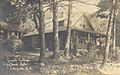
Granite Cottage in 1907, Spofford Lake
-
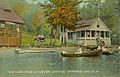
Summer cottages on Spofford Lake in 1917
-
Pine Grove Springs Hotel, Spofford Lake in 1913


Geography of Chesterfield
Land and Water
Chesterfield covers a total area of about 123.1 square kilometers (47.5 square miles). Most of this area, about 118.0 square kilometers (45.6 square miles), is land. The rest, about 5.1 square kilometers (2.0 square miles), is water. Water makes up about 4.17% of the town's total area.
The Connecticut River forms the western border of Chesterfield. The highest point in the town is Davis Hill. It is about 1427 feet (435 meters) above sea level. All the water in Chesterfield flows into the Connecticut River watershed. This means all the streams and rivers in the town eventually lead to the Connecticut River.
Roads and Nearby Towns
State routes 9 and 63 help people travel through Chesterfield.
Chesterfield shares its borders with several other towns:
- Westmoreland (to the north)
- Keene (to the northeast)
- Swanzey (to the east)
- Winchester (to the south)
- Hinsdale (to the south)
- Brattleboro, Vermont (to the southwest)
- Dummerston, Vermont (to the west)
Population Changes Over Time
| Historical population | |||
|---|---|---|---|
| Census | Pop. | %± | |
| 1790 | 1,905 | — | |
| 1800 | 2,161 | 13.4% | |
| 1810 | 1,839 | −14.9% | |
| 1820 | 2,110 | 14.7% | |
| 1830 | 2,040 | −3.3% | |
| 1840 | 1,765 | −13.5% | |
| 1850 | 1,680 | −4.8% | |
| 1860 | 1,434 | −14.6% | |
| 1870 | 1,289 | −10.1% | |
| 1880 | 1,173 | −9.0% | |
| 1890 | 1,046 | −10.8% | |
| 1900 | 981 | −6.2% | |
| 1910 | 770 | −21.5% | |
| 1920 | 601 | −21.9% | |
| 1930 | 704 | 17.1% | |
| 1940 | 591 | −16.1% | |
| 1950 | 970 | 64.1% | |
| 1960 | 1,405 | 44.8% | |
| 1970 | 1,817 | 29.3% | |
| 1980 | 2,561 | 40.9% | |
| 1990 | 3,112 | 21.5% | |
| 2000 | 3,542 | 13.8% | |
| 2010 | 3,604 | 1.8% | |
| 2020 | 3,552 | −1.4% | |
| U.S. Decennial Census | |||
The population of Chesterfield has changed a lot over the years. In 1790, there were 1,905 people living there. The population grew to over 2,000 in the early 1800s. Then, it slowly went down for many years. By 1920, only 601 people lived in Chesterfield.
However, after 1940, the population started to grow again. It has been growing steadily since then. In 2020, the town had 3,552 residents. The average age of people in Chesterfield in 2000 was 40 years old.
Fun Places to Visit

There are many interesting places to see and explore in Chesterfield:
- Asbury Church (1844) - A historic church with a long history.
- Chesterfield Gorge Natural Area - A beautiful natural area with a deep gorge.
- Pisgah State Park - A large park great for hiking and enjoying nature.
- Madam Sherri Forest - A unique forest with interesting ruins and trails.
Famous People from Chesterfield
Many notable people have connections to Chesterfield:
- Helen Field Comstock (1840–1930) - A poet and someone who helped others.
- William H. Haile (1833–1901) - A successful businessman and politician.
- Harlan Fiske Stone (1872–1946) - He became a very important judge, serving as the 12th Chief Justice of the United States.
- Winthrop E. Stone (1862–1921) - A professor and college president.
- Charles Tazewell (1900–1972) - An actor, radio writer, and author of children's books.
See also
 In Spanish: Chesterfield (Nuevo Hampshire) para niños
