Westmoreland, New Hampshire facts for kids
Quick facts for kids
Westmoreland, New Hampshire
|
|
|---|---|
|
Town
|
|

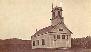
Union Church c. 1915
|
|

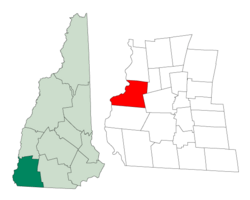
Location in Cheshire County, New Hampshire
|
|
| Country | United States |
| State | New Hampshire |
| County | Cheshire |
| Incorporated | 1752 |
| Villages |
|
| Area | |
| • Total | 36.8 sq mi (95.4 km2) |
| • Land | 35.8 sq mi (92.7 km2) |
| • Water | 1.0 sq mi (2.7 km2) 2.80% |
| Elevation | 417 ft (127 m) |
| Population
(2020)
|
|
| • Total | 1,706 |
| • Density | 48/sq mi (18.4/km2) |
| Time zone | UTC-5 (Eastern) |
| • Summer (DST) | UTC-4 (Eastern) |
| ZIP code |
03467
|
| Area code(s) | 603 |
| FIPS code | 33-82660 |
| GNIS feature ID | 0873753 |
Westmoreland is a town located in Cheshire County, New Hampshire, in the United States. In 2020, about 1,706 people lived there. Westmoreland has a long history as a farming town, with lots of land good for growing crops.
Contents
A Look Back: Westmoreland's History
First People: Native American History
Before Europeans arrived, many Native American tribes lived in the area that is now Westmoreland. The upper Connecticut River valley was a favorite spot for Native American villages. They mostly used these villages for hunting and fishing. Tribes like the Pennacook and the Abenaki often visited this region.
In the 1670s, a conflict called King Philip's War caused most Native American tribes to move to Canada. Native peoples had a different idea about land ownership than the English settlers. This led to many misunderstandings and disagreements. English settlers buying land and building permanent homes changed the hunting and fishing traditions of the Native tribes.
Even though Native American activity was common in Westmoreland, not many ancient sites have been found. There is a "Pow-wow Rock" off Poocham Road. The name Poocham comes from an Abenaki word meaning "gathering place." This large rock was left behind by glaciers. It measures about 12 by 14 by 8 feet high. Records say that Native American pow-wows, or gatherings, and prisoner exchanges happened at this spot.
Early European Settlements
Westmoreland was first known as "Great Meadow." In 1735, Governor Jonathan Belcher of Massachusetts gave out the land. It was called "Number 2." This was the second in a line of fort towns along the Connecticut River. These forts were built to protect the colonies from Native American attacks. This part of the river was a popular Native American campsite. Settlers who came starting in 1741 were attacked several times.
Later, the border between Massachusetts and the Province of New Hampshire was set. "Number 2" ended up on the New Hampshire side. So, in 1752, Governor Benning Wentworth gave the town a new grant. He named it Westmoreland, after John Fane, the 7th Earl of Westmorland.
The Park Hill Meetinghouse was built in 1762. It has a bell made by Paul Revere. Many people think it is one of the most beautiful churches in New England. It was moved to its current location by oxen in 1779. The church was updated in 1826.
Westmoreland's Geography
Westmoreland covers a total area of 95.4 square kilometers (about 36.8 square miles). Most of this area, 92.7 square kilometers, is land. The remaining 2.7 square kilometers, or 2.80%, is water. The town's western border is the Connecticut River. This river also forms the state border with Vermont.
The highest point in Westmoreland is Hyland Hill. It is 460 meters (1,510 feet) high. This hill is on the eastern border of the town. Even though it is now private land, it is a popular spot for hiking and hunting for local people.
You can reach Westmoreland using state routes 12 and 63.
Neighboring Towns and States
Westmoreland shares its borders with several other towns and states:
- Walpole (to the north)
- Surry (to the northeast)
- Keene (to the east)
- Chesterfield (to the south)
- Dummerston, Vermont (to the southwest)
- Putney, Vermont (to the west)
Population Changes in Westmoreland
| Historical population | |||
|---|---|---|---|
| Census | Pop. | %± | |
| 1790 | 2,018 | — | |
| 1800 | 2,066 | 2.4% | |
| 1810 | 1,937 | −6.2% | |
| 1820 | 2,029 | 4.7% | |
| 1830 | 1,647 | −18.8% | |
| 1840 | 1,546 | −6.1% | |
| 1850 | 1,678 | 8.5% | |
| 1860 | 1,285 | −23.4% | |
| 1870 | 1,256 | −2.3% | |
| 1880 | 1,095 | −12.8% | |
| 1890 | 830 | −24.2% | |
| 1900 | 875 | 5.4% | |
| 1910 | 758 | −13.4% | |
| 1920 | 615 | −18.9% | |
| 1930 | 745 | 21.1% | |
| 1940 | 755 | 1.3% | |
| 1950 | 789 | 4.5% | |
| 1960 | 921 | 16.7% | |
| 1970 | 998 | 8.4% | |
| 1980 | 1,452 | 45.5% | |
| 1990 | 1,596 | 9.9% | |
| 2000 | 1,747 | 9.5% | |
| 2010 | 1,874 | 7.3% | |
| 2020 | 1,706 | −9.0% | |
| U.S. Decennial Census | |||
In the year 2000, there were 1,747 people living in Westmoreland. These people lived in 576 households, and 445 of those were families. The population density was about 48.7 people per square mile. There were 618 homes, with an average of 17.2 homes per square mile.
Most of the people in Westmoreland were White (97.82%). A small number were African American (0.34%), Native American (0.29%), or Asian (0.80%). Some people were from other races (0.34%), and 0.40% were from two or more races. About 0.92% of the population was Hispanic or Latino.
Of the 576 households, 31.6% had children under 18 living with them. About 69.6% were married couples. Only 3.8% had a female head of household with no husband present. About 22.7% of households were not families. Around 17.4% of households were just one person, and 7.8% were one person aged 65 or older. The average household had 2.57 people, and the average family had 2.92 people.
The median age in Westmoreland was 43 years old. About 19.9% of the population was under 18. About 6.6% were between 18 and 24. People aged 25 to 44 made up 26.8%. Those aged 45 to 64 were 27.4%. And 19.3% were 65 or older. For every 100 females, there were 97.6 males. For every 100 females aged 18 and over, there were 99.6 males.
The median income for a household was $55,875. For families, the median income was $62,857. Men earned a median income of $40,515, while women earned $28,456. The average income per person in the town was $24,488. A very small number of families (0.4%) and people (2.5%) lived below the poverty line. This included no one under 18, but 5.4% of those aged 65 or older.
Famous People from Westmoreland
Westmoreland has been home to several notable individuals:
- Clinton Babbitt (1831–1907), a US congressman.
- Goldsmith Bailey (1823–1862), another US congressman.
- Nathaniel S. Benton (1792–1869), who served as Secretary of State and a state senator for New York.
- Joseph Buffum, Jr. (1784–1874), a US congressman and judge.
- Martin Butterfield (1790–1866), a US congressman.
- Levi K. Fuller (1841–1896), who became the 44th governor of Vermont.
- John M. Goodenow (1782–1838), a US congressman.
- Ernest Hebert (born 1941), a well-known author.
- Thomas B. Marsh (1800–1866), a religious leader.
- Robert Olmstead (born 1954), another author.
- Maria Brewster Brooks Stafford (1809–1896), an educator.
- Everett Warner (1877–1963), an artist and print-maker.
See also
 In Spanish: Westmoreland (Nuevo Hampshire) para niños
 | William M. Jackson |
 | Juan E. Gilbert |
 | Neil deGrasse Tyson |

